Give us feedback!


 See all

Our philosophy is simple. We want to encourage you to dream. BIG! Then we help you plan your trip, get the most out of it while you're traveling and help you share your experience with friends.
Join Now It's FREE
Dream Packages
Duration: 2 days
Price: $469.00
Price: $469.00
Duration: 12 hours 30 minutes
Price: $289.36
Price: $289.36
Duration: 12 hours
Price: $224.21
Price: $224.21
Duration: 10 hours
Price: $224.21
Price: $224.21
Related Categories
Dreams Still To Do
Checked-Off Dreams
Dreams Still To Do
Checked-Off Dreams
Advertisement
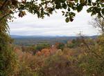
Explore Best Hikes in the US
-
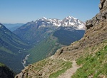
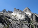
Hike to Grinnell Glacier, Glacier National Park, Montana
Grinnell Glacier is located in the heart of Glacier National Park. The glacier is named for George Bird Grinnell, an early American conservationist and explorer, who was also a strong advocate of ensuring the creation of Glacier National Park. The glacier is in the Lewis Range and rests on the north flank of Mount Gould at an altitude averaging 7,000 feet (2,100 m), i... -
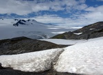
Hike Harding Icefield Trail, Kenai Fjords National Park, Alaska
The Harding Icefield is an expansive icefield located in the Kenai Mountains of the Kenai Peninsula in Alaska. It is also partially located in Kenai Fjords National Park. The 8.2-mile round trip Harding Icefield Trail is a strenuous and spectacular day hike. Starting on the valley floor, the trail winds through cottonwood and alder forests, passes though meadows fill... -
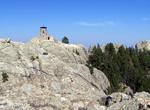
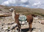
Summit Harney Peak, South Dakota
Harney Peak is the highest natural point in South Dakota and is located in the Black Elk Wilderness area, in southern Pennington County, in Black Hills National Forest. At 7,242 feet (2,207 m), it is also the highest summit in the United States east of the Rocky Mountains and the highest point in the Black Hills. The summit can be reached from Sylvan Lake, Camp Reming... -
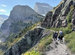
Hike Highline Trail, Glacier National Park, Montana
The Highline Trail in Glacier National Park is a scenic hiking trail stretching 7.6 miles (12.2 km) from Logan Pass to Granite Park Chalet, and continuing another 11.9 miles (19.2 km) from there to Fifty Mountain Campground. The trail follows the Garden Wall ridge and the continental divide for most of its length. The trail offers very scenic views of glaciated U-shap... -
Hike High Sierra Trail, Sequoia National Park, California
The High Sierra Trail is a hiking trail in Sequoia National Park, California. The trail crosses the Sierra Nevada from west to east. See the NPS High Sierra Trail page From the plateau of the Giant Forest at Crescent Meadow {elevation 6,700 feet / 2,000 metres) the trail travels high on the northern wall of the canyon of the Middle Fork of the Kaweah River to Bearpaw ... -
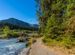
Hike Hoh River Trail, Olympic National Park, Washington
The Hoh Rain Forest on the west side of Olympic National Park preserves one of the finest temperate rain forests in the U.S., a place that gets up to 14 feet of rain a year. This hike puts you right into the deep, mossy, densely forested core. Parallel with the Hoh River, this mostly level trail is mainly under the canopy of the massive old-growth trees—bigleaf ... -
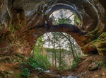
Hike to Hopewell Arch, Kentucky
Hopewell Arch, Double Deer Arch, and Snow Arch is a 2.3 mile trail located near Pine Ridge, Kentucky. Look for all the wild flowers on this moderate out and back trail hike that is considered as moderate. The trail is primarily used for hiking, nature trips, and bird watching and is accessible year-round. -
Hike or Ride Horse-Shoe Trail, Pennsylvania
The Horse-Shoe Trail is a 140-mile (230 km) trail that runs from the western edge of Valley Forge National Historical Park westward toward Harrisburg, Pennsylvania. It ends about 15 miles northeast of Harrisburg at the Appalachian Trail. The trail was developed for equestrian and pedestrian use, according to the Horse-Shoe Trail Club guide, hence the name (horse + sho... -
Hike John Muir Trail, California
The John Muir Trail (JMT) is a long-distance trail in the Sierra Nevada mountain range of California, running 211 miles (340 km) between the northern terminus at Happy Isles in Yosemite Valley and the southern terminus located on the summit of Mount Whitney. For almost all of its length, the trail is in the High Sierra backcountry and wilderness areas. For about 160 m... -
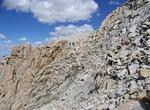
Summit Longs Peak, Rocky Mountain National Park, Colorado
Longs Peak is one of the 54 mountains with summits over 14,000 feet in Colorado. It can be prominently seen from Longmont, Colorado, as well as from the rest of the Colorado Front Range. It is named after Major Stephen Long, who explored the area in the 1820s. Longs Peak is one of the most prominent mountains in Colorado, rising up to 9,500 feet above the western edge... -
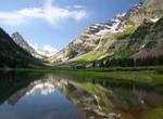
Summit Maroon Bells, Elk Mountains, Colorado
The Maroon Bells are two peaks in the Elk Mountains, Maroon Peak and North Maroon Peak, separated by about a third of a mile. The mountain is on the border between Pitkin County and Gunnison County, Colorado, United States, about 12 miles southwest of Aspen. Both peaks are counted as fourteeners. Maroon Peak, at 14,156 feet, is the 27th highest peak in Colorado; North... -
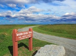
Hike Mason-Dixon Trail
The Mason-Dixon Trail is a 193-mile (311 km), blue-blazed footpath that connects the Appalachian Trail with the Brandywine Trail, passing through Gifford Pinchot State Park and White Clay Creek Preserve in Pennsylvania and White Clay Creek State Park in Delaware. The trail starts near Mount Holly Springs at Whiskey Springs on the Appalachian Trail, in Cumberland Count... -
Hike Metacomet Trail, Connecticut
The Metacomet Trail is a 62.7-mile (100.9 km) Blue-Blazed hiking trail that traverses the Metacomet Ridge of central Connecticut and is a part of the newly designated 'New England National Scenic Trail'. Despite being easily accessible and close to large population centers, the trail is considered remarkably rugged and scenic. The route includes many areas of unique e... -
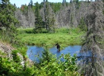
Hike Minong Ridge Trail, Isle Royale National Park
The Minong Ridge Trail runs 23 miles along the northern edge of Isle Royale National Park and usually takes 3-4 days to complete. It is considered to be a much tougher trail than the more popular Greenstone Ridge Trail and is considered the most challenging stretch of the Isle Royale’s 161-mile trail system due to the rough terrian and all the up and down hiking... -
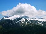
Summit Mount Olympus, Olympic National Park, Washington
Mount Olympus is the tallest and most prominent mountain in the Olympic Mountains of western Washington state. Located on the Olympic Peninsula, it is the central feature of Olympic National Park. Many people attempt this summit each year, but the average success rate is considered low mainly due to all the rain/snow in this region of Washington, having a long approac...
Price: $263.50