Give us feedback!


 See all

Our philosophy is simple. We want to encourage you to dream. BIG! Then we help you plan your trip, get the most out of it while you're traveling and help you share your experience with friends.
Join Now It's FREE
Dream Packages
Duration: 4 hours
Price: $149.99
Price: $149.99
Duration: 4 days
Price: $772.57
Price: $772.57
Duration: 12 hours
Price: $224.21
Price: $224.21
Duration: 10 hours
Price: $121.33
Price: $121.33
Related Categories
- Australian National Parks & Reserves
- Canadian National Parks
- Canyoneering
- Day Hikes
- Guided Hikes
- In the Mountains
- Mountaineering
- Mountains
- New Zealand Great Walks
- New Zealand National Parks
- Parks & Reserves
- Rock Climbing
- South African National Parks
- UK National Parks
- UNESCO Parks & Preserves
- US Historical Parks (NHP)
Dreams Still To Do
Checked-Off Dreams
Dreams Still To Do
Checked-Off Dreams
Advertisement
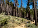
Explore Hikes & Treks
-
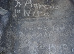
Visit Marcos de Niza Trail, Phoenix, Arizona
Marco de Niza was an explorer that made his way through Arizona into what today is known as New Mexico. Rumor has it that he traveled through South Mountain, while onto his way to discover this land. In the 1920s Matthew E. Bellew announced the discovery of a petroglyph on his land near Phoenix that appeared to have been left by Marcos de Niza. The inscription, writt... -
Hike Maridalen Valley, Norway
Maridalen is a valley situated just north of Oslo, Norway, just above the suburb of Kjelsås. Most of the valley is made up of a lake known as Maridalsvannet, that serves as the primary source of drinking water for 90% of Oslo's population. The valley is a popular recreational area with many hiking trails and cycle tracks for summer usage, and groomed cross count... -
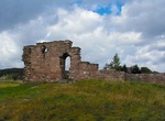
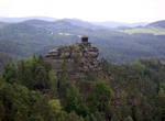
Hike to Mariina Skála, Bohemian Switzerland, Czechia
The Mariina skála is a 428 m rocky hill in the Czech Republic, located in the region of Bohemian Switzerland not far from Jetřichovice (Dittersbach). It was named in the 19th century after Princess Marie Kinsky. Before that, the hill was known as the "Spitzgestein" or "Grosser Spitziger". The hill is one of the best viewing points in Bohemian Switzerland. In 18... -
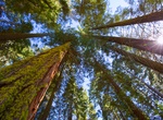
Hike, Ski or Tram to Mariposa Grove, Yosemite National Park
Mariposa Grove is a sequoia grove located near Wawona, California, United States, in the southernmost part of Yosemite National Park. It is the largest grove of giant sequoias in the park, with several hundred mature examples of the tree. Two of its trees are among the 30 largest giant sequoias in the world. The grove closed on July 6, 2015, for a restoration project ... -
Hike Mariposa Grove Trail to Wawona Point, Mariposa Grove Trail
Begin at Mariposa Grove Arrival Area. This wide and relatively smooth trail follows a route that people have used to access the grove for generations. See famous sequoias such as the Bachelor and Three Graces, the Faithful Couple, and the Clothespin Tree along this somewhat strenuous route to the upper reaches of the grove. Continue to historic Wawona Point, an overlo... -
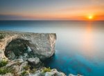
Visit Marks & Dukes Window, Malta
Marks & Dukes Window is a stunning natural arch north of Mellieha. The best way to get to Marks & Dukes Window is to take a boat or drive to the end of the road of L-Ahrax in Mellieha and park in front of the Chapel of Immaculate Conception. Walk pass it, there is a path alongside the cliffs. The cliffs along the coast hold the biggest Yelkouan Shearwater col... -
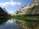
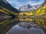
Summit Maroon Bells, Elk Mountains, Colorado
The Maroon Bells are two peaks in the Elk Mountains, Maroon Peak and North Maroon Peak, separated by about a third of a mile. The mountain is on the border between Pitkin County and Gunnison County, Colorado, United States, about 12 miles southwest of Aspen. Both peaks are counted as fourteeners. Maroon Peak, at 14,156 feet, is the 27th highest peak in Colorado; North... -
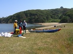
Hike to Maroon Lake, Colorado
Maroon Lake in Pitkin County, Colorado -
Hike to Marshall Beach, Tomales Bay, California
Marshall Beach is on the Tomales Bay side of Point Reyes National Seashore, south of Tomales Point. The parking area is a 3-kilometer (2-mile) drive on a dirt road. It is then a 1.9-kilometer (1.2-mile) hike from the parking area to the beach. Directions to Marshall Beach Trailhead: Allow 30 minutes for the drive from the Bear Valley Visitor Center. From the Bear Val... -
Hike Marshal South Home Trail (Ghost Mountain - Yaquitepec), Anza-Borrego Desert State Park, California
In 1930, Marshal South, artist and also author of western books and a regular column, "Desert Refuge" for Desert Magazine, moved with his poet wife, Tanya, to Ghost Mountain in Anza-Borrego Desert State Park, not far from Highway S-2 where they built an adobe cabin. They had a family there and lived a primitive lifestyle in tune with nature, with Marshal recounting th... -
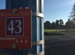
Hike Marston Point Trails, Balboa Park, San Diego, California
On the southwest side of the park is a gateway into four trails: The 1.0 mile trail follows sidewalks to take tree-lined route loops through the south side of Balboa Park's West Mesa. Difficulty level: Easy. Follow the #41 round blue trail markers. The 1.6 mile trail follows sidewalks, stairways, unpaved trails and some road surfaces. Experience unique perspectives of... -
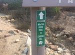
Hike or Ride Martha's Grove Trail, San Diego, California
Martha's Grove Trail is a one-way (north to south) 1.62 miles single track trail that starts at Goodan Ranch Staging Area in southern Poway. The trail starts off in Sycamore Canyon Reserve and ends in Mission Trails Regional Park. Retrun to Goodan Ranch Staging Area by going back on the 1.83 miles Sycamore Canyon Road. -
Hike to Martial Glacier, Ushuaia, Argentina
Martial Glacier hike is 3.7-mile out-and-back trail near Ushuaia. It's name to Captain Ferdinand Martial of the Mission Scientifique du Cap Horn, a French expedition to the region of Cape Horn that arrived in Tierra del Fuego in September 1882 on board of the ship Romanche -
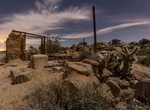
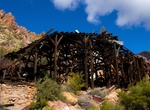
Hike to Martinez Mine, Box Canyon, Arizona
The Martinez Mine in Box Canyon, near Superior, Arizona, is a historic mining site known for lead, silver, copper, gold, and zinc, accessible via a challenging 4x4 trail that's popular for hiking, off-roading, and exploring old ruins like the Martinez cabin, offering a mix of mining history and scenic desert views in a remote setting. -
Hike Marufo Vega Trail, Big Bend National Park, Texas
This is a strenuous, but spectacular day hike or overnight backpacking trip through stark but stunning terrain. The trail is named after Gregorio Marufo, who once grazed goats along the Rio Grande.From the trailhead, the route soon climbs steeply to a high plateau, then through a series of rugged drainages. After approximately 3.5 miles the trail splits into a north...

Price: $371.99