Give us feedback!


 See all

Our philosophy is simple. We want to encourage you to dream. BIG! Then we help you plan your trip, get the most out of it while you're traveling and help you share your experience with friends.
Join Now It's FREE
Dream Packages
Duration: 4 days
Price: $772.57
Price: $772.57
Duration: 6 hours 30 minutes
Price: $167.71
Price: $167.71
Duration: 3 hours 15 minutes
Price: $371.99
Price: $371.99
Duration: 10 hours
Price: $121.33
Price: $121.33
Related Categories
- Australian National Parks & Reserves
- Canadian National Parks
- Canyoneering
- Day Hikes
- Guided Hikes
- In the Mountains
- Mountaineering
- Mountains
- New Zealand Great Walks
- New Zealand National Parks
- Parks & Reserves
- Rock Climbing
- South African National Parks
- UK National Parks
- UNESCO Parks & Preserves
- US Historical Parks (NHP)
Dreams Still To Do
Checked-Off Dreams
Dreams Still To Do
Checked-Off Dreams
Advertisement
Explore Hikes & Treks
-
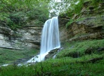
Hike to Abrams Falls, Bristol, Virginia
Note: The trail and falls are on private property. You can not hike this area unless approved by the land owner - who is hard to get in touch with. See https://www.afcrent.com/things-to-do for more details. The trailhead is at the end of the cul-de-sac of Abrams Falls Road. The 1 mile out and back trail is narrow and steep in places. -
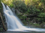
Hike Abrams Falls Trail, Great Smoky Mountains National Park
The Abrams Falls Trail is an American hiking trail, in the Great Smoky Mountains National Park of Blount County, Tennessee. It is 4.2 mi (2.5 to Abrams Falls); 6.8 km (4.0 to Abrams Falls). Easy (to falls); Moderate (to junction). The trail runs parallel to Abrams Creek and passes Abrams Falls, one of the most voluminous waterfalls in the national park, before termina... -
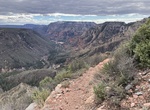
Hike A.B. Young Trail, Red Rock-Secret Mountain Wilderness, Arizona
The A.B.Young Trail leaves from the southernmost end of the Bootlegger Picnic Area. Take steps down to the creek, find a suitable place to "boulder hop" or wade the stream, cross the creek and find an old metal sign indicating the trailhead. It immediately begins a moderately steep ascent and enters wilderness area. The shade of the creek area is quickly lost and nic... -
Hike Acadia Mountain Trail, Acadia National Park, Maine
The 2.5 miles (4 km) Acadia Mountain Trail offers views of Somes Sound and a steep descent to fire road. Pets are not recommeded for this trail. Starts/ends at: Acadia Mountain Parking Area -
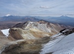
Summit Acotango, Bolivia & Chile
Acotango is the central and highest of a group of stratovolcanoes straddling the border of Bolivia and Chile. It is 6,052 metres (19,856 ft) high. The group is known as Kimsa Chata and consists of three mountains: Acotango, Umurata (5,730 metres (18,799 ft)) north of it and Capurata (5,990 metres (19,652 ft)) south of it. The group lies along a north&nd... -
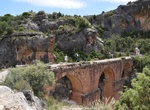
Hike to Acueducto & Túneles de Peña Cortada, Valencia, Spain
The Roman Aqueduct of Peña Cortada, also Aqueduct of La Serrada or Aqueduct of La Serranía runs through the municipalities of Tuéjar, Chelva, Calles and Domeño, in the Province of Valencia. Although a recent publication by the archaeologist and doctor in architecture of the Polytechnic University of Valencia Miquel R. Martí Maties, d... -
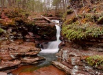
Hike to Adams Falls, Ricketts Glen State Park, Pennsylvania
Adams Falls is a bridal veil type waterfall, dropping 36 feet (11 m) in front of Catskill Formation rock. -
Hike to Adobe Falls, San Diego, Calcifornia
Adobe Falls (aka Aztec Falls) is located next to Interstate 8 on private property owned by San Diego State. Officers do patrol the area and respond to calls from neighbors. Neighbors have expressed frustration with the hike in noise, trash and traffic in the area. -
Hike Aeia Loop Trail, Oahu, Hawaii
The ‘Aiea Loop Trail is 4.8-mile trail that begins and ends in the park. This trail runs along the ridge on the west side of Halawa Valley and offers views of the southern coastline of O‘ahu from Pearl Harbor (Pu‘uloa) and the Wai‘anae Range to Honolulu and Diamond Head (Le‘ahi). Much of this area was replanted by foresters in the late 1... -
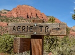
Mountain Bike or Hike Aerie Loop Trail, Sedona, Arizona
This 5.0-mile loop trail near Sedona is a popular trail for mountain biking, but hikers can still enjoy some solitude during quieter times of day. Aerie Trailhead is a great place for stargazing. -
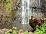
Hike to 'Āfareaitu Waterfall, Moorea, French Polynesia
'Āfareaitu Waterfall offers a great 0.9 mile out and back hike with lovely swimming hole/waterfall. -
Hike Afton Canyon “Spooky Cave”, California
An interesting narrow slot to visit when in Afton Canyon. The canyon is approached from the bottom by ascending the canyon itself. First you go up canyon climbing the drops with partner assists and occasionally some static ropes. Then you come back down with the option to rappel or just handline it. Make sure you pack a headlamp. The canyon gets so narrow and the wall... -
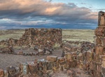
Hike to Agate House Pueblo, Petrified Forest National Park, Arizona
Agate House is a partially reconstructed Puebloan building in Petrified Forest National Park, built almost entirely of petrified wood. The eight-room pueblo has been dated to approximately the year 900 and occupied through 1200, of the Pueblo II and Pueblo III periods. The agatized wood was laid in a clay mortar, in lieu of the more usual sandstone-and-mortar masonry ... -
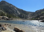
Hike to Agnew Lake, June Lake, California
Take the Rush Creek Trail in June Lake. In 2.2 miles, you will reach Agnew Lake where a small footbridge crosses the dam and outlet. Return the same route. -
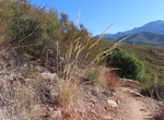
Hike Agua Caliente Creek Trail, Warner Springs, California
Agua Caliente Creek Trail is a 10.6 mile moderate out and back trail located near Warner Springs, California that features beautiful wild flowers. Leashed dogs allowed.


Price: $263.50