Give us feedback!


 See all

Our philosophy is simple. We want to encourage you to dream. BIG! Then we help you plan your trip, get the most out of it while you're traveling and help you share your experience with friends.
Join Now It's FREE
Dream Packages
Duration: 3 hours 15 minutes
Price: $371.99
Price: $371.99
Duration: 6 to 10 hours
Price: $86.83
Price: $86.83
Duration: 12 hours
Price: $154.81
Price: $154.81
Duration: 4 hours
Price: $149.99
Price: $149.99
Related Categories
- Australian National Parks & Reserves
- Canadian National Parks
- Canyoneering
- Day Hikes
- Guided Hikes
- In the Mountains
- Mountaineering
- Mountains
- New Zealand Great Walks
- New Zealand National Parks
- Parks & Reserves
- Rock Climbing
- South African National Parks
- UK National Parks
- UNESCO Parks & Preserves
- US Historical Parks (NHP)
Dreams Still To Do
Checked-Off Dreams
Dreams Still To Do
Checked-Off Dreams
Advertisement
Explore Hikes & Treks
-
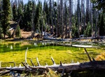
Hike Alpine Pond Nature Trail, Cedar Breaks National Monument, Utah
The Alpine Pond Nature Trail is a two-mile double-loop trail through forest and meadows. The lower trail offers excellent views of the "breaks." The upper trail takes you past meadows of native wildflowers, through spruce-fir-aspen forest, and past ancient deposits of volcanic materials. Located half-way through the loop is the Alpine pond. This natural, spring-fed po... -
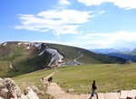
Hike Alpine Ridge Trail, Rocky Mountain National Park, Colorado
The Alpine Ridge Trail begins from the far end of the parking area for the Alpine Visitor Center in Rocky Mountain National Park. It's a short hike, the trail is fairly steep, gaining more than 200 feet in just three-tenths of a mile. During the spring and early summer hikers will be treated to a wide variety of wildflowers. -
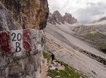
Hike Alpine Road via Ferrata, Italy
The Way of Alpine, also known as the Alpine Trail, is one of the most famous and classic climbing routes of the Alps. Located in the Dolomites of Sesto in the Alto Adige and Veneto. This road was used during the First World War as a fast and efficient connection from Alpine between the fork Giralba and the pitch of Sentry . The route was converted into a trail for h... -
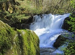
Hike Alsea Falls Trail & Green Peak Falls Trail, Oregon
Alsea Falls, is a waterfall located in the heart of the Central Oregon Coast Range, just west of Monroe, in Benton County, in the U.S. state of Oregon. It totals 30 feet fall in one gradual cascade and is the centerpiece attraction of the Alsea Falls trailhead and Recreation Site. Alsea Falls is located along a Bureau of Land Management Back Country Byway surrounded b... -
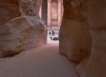
Hike Al-Siq, Petra, Jordan
Al-Siq (the shaft) is the main entrance to the ancient city of Petra in southern Jordan. The dim, narrow gorge (in some points no more than 3 meters wide) winds its way approximately one mile and ends at Petra's most elaborate ruin, Al Khazneh (The Treasury). The Siq is a natural geological fault produced by tectonic forces and worn smooth by water erosion. The walls ... -
Trek Alta Via 1 (Dolomite High Route 1), Dolomites, Italy
Alta Via 1 is a 150-kilometre-long high-level public footpath which runs through the eastern Dolomites in Italy. It is also known as the Dolomite High Route 1. It passes through some of the finest scenery in the Dolomites. The path runs south from Pragser Wildsee, near Toblach, to Belluno. Prags can be accessed by bus, and Belluno has both train and bus services. This... -
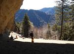
Hike Alum Cave Trail, Great Smoky Mountains National Park, Tennessee
The Alum Cave Trail (also referred to as Alum Cave Bluff Trail) is an American hiking trail in the Great Smoky Mountains National Park, in Sevier County, Tennessee. The trail ascends Mount Le Conte, the tallest (and sixth highest) mountain east of the Mississippi River and passes by many notable landmarks, such as Arch Rock, Inspiration Point, the Duckhawk Peaks,... -
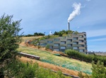
Ski, Hike or Climb Amager Bakke (Copenhill), Copenhagen, Denmark
Amager Bakke (Amager Hill) also known as Amager Slope or Copenhill, is a combined heat and power waste-to-energy plant in Amager, Copenhagen, Denmark. It was designed by Bjarke Ingels Group with a 85 m (279 ft) tall sloped roof that doubles as year-round artificial ski slope, hiking slope and climbing wall, which opened to the public in early 2019. It opened in 2017, ... -
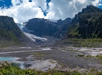
Hike to Amarillo Glacier, Pumalín National Park, Chile
Amarillo Glacier is at the southern base of Michinmahuida volcano in Pumalín National Park in Chile. -
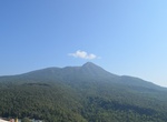
Trek Amata Mountain, Thandwe, Myanmar
The Amata Mountain trek starts at Jatetaw Village. The path is easy and pleasant. On the top of the mountain you will see meditation centre, statue of Buddha and beautiful ocean views. -
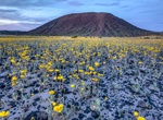
Hike to Amboy Crater, Southern California
Amboy Crater and Lava Field is an extinct North American cinder cone type of volcano that rises above a 70-square-kilometer (27 sq mi) lava field in southern California. They are located in the Mojave Desert equidistant and about 75 miles (120 km) between Barstow to the west and Needles to the east, and 2.5 miles (4.0 km) southwest of historic U.S. Route 66, near the ... -
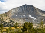
Summit Amelia Earhart Peak, Tuolumne County, California
Amelia Earhart Peak is a summit in Tuolumne County, California, in the United States. With an elevation of 11,978 feet (3,651 m), Amelia Earhart Peak is the 304th highest summit in the state of California. The summit was named in the 1960s for aviator Amelia Earhart. Permits: None needed for day use but required for overnight travel; visit Tuolumne Meadows Wilderness ... -
Hike American Discovery Trail Coast to Coast
The American Discovery Trail is a system of recreational trails and roads which collectively form a coast-to-coast hiking and biking trail across the mid-tier of the United States. It starts on the Delmarva Peninsula on the Atlantic Ocean and ends on the northern California coast on the Pacific Ocean, and is signed on over 6,800 miles (10,900 km) of trail. This includ... -
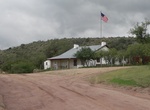
Drive Through American Flag, Arizona
American Flag is a ghost town in Pinal County, Arizona, five miles southeast of Oracle. The town was established in the late 1870s but shortly after 1890, the town had become abandoned. American Flag was founded by prospector Isaac Lorraine as the American Flag mine and mining camp in the late 1870s. In 1881 the town was sold to the Richardson Mining Company of New Yo... -
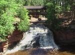
Hike Amnicon Falls Trail, Amnicon Falls State Park, Wisconsin
The most popular trail to view the falls is the 0.25 mile trail on the island. This trail gives you viewing access to the three main falls; Upper, Lower and Snake Pit. It also provides viewing opportunities to other smaller water falls and pools. An additional 0.5 miles of trail goes up and down the river to view many other pools and cascades. The two river walks are...


Price: $199.57