Give us feedback!


 See all

Our philosophy is simple. We want to encourage you to dream. BIG! Then we help you plan your trip, get the most out of it while you're traveling and help you share your experience with friends.
Join Now It's FREE
Dream Packages
Duration: 4 hours
Price: $129.99
Price: $129.99
Duration: 2 days
Price: $398.24
Price: $398.24
Duration: 30 minutes
Price: $263.77
Price: $263.77
Duration: 12 hours
Price: $160.26
Price: $160.26
Related Categories
- Australian National Parks & Reserves
- Canadian National Parks
- Canyoneering
- Day Hikes
- Guided Hikes
- In the Mountains
- Mountaineering
- Mountains
- New Zealand Great Walks
- New Zealand National Parks
- Parks & Reserves
- Rock Climbing
- South African National Parks
- UK National Parks
- UNESCO Parks & Preserves
- US Historical Parks (NHP)
Dreams Still To Do
Checked-Off Dreams
Dreams Still To Do
Checked-Off Dreams
Advertisement
Explore Hikes & Treks
-
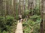
Hike Sand Point Trail, Olympic National Park, Washington
Sand Point Trail is 2.8 miles one way partly on boardwalk from near the ranger station to the coast. A 2.9 mile beach walk connects to Cape Alava Trail, making a 9.0 mile loop. The trailhead is near Ozette Campground. -
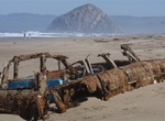
Hike Sandspit Beach, Morro Bay State Park, California
The Sand Spit Trail is a 10.2 mile out and back trail in Morro Bay State Park, California. -
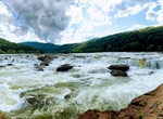
Hike to Sandstone Falls, New River, West Virginia
Sandstone Falls is a sight that should not be missed. This is the largest waterfall on the New River spanning 1500 feet across. Divided by islands, the falls drop from 10 to 25 feet. A ¼ mile, handicapped accessible boardwalk crosses two bridges leading to islands and observation decks offering fantastic views of the falls and access to fishing areas. The board... -
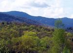
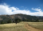
Hike Sandstone Peak Trail, Malibu, California
Sandstone Peak (3,114 feet (949 m)) is the tallest point in the Santa Monica Mountains. -
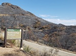
Hike Sandstone Quarry Trail, Red Rock Canyon, Nevada
The Sandstone Quarry Trailhead Parking area serves several trails. The northbound trailhead serves the Turtlehead Peak, Calico Tanks, Calico Hills Loop, and Grand Circle trails, as well as the route to Gray Cap Peak. The southbound trailhead serves the Calico Hills and Grand Circle trails. Drive around the one-way Scenic Loop Road to Sandstone Quarry Road, which is a... -
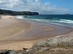
Hike to Sandwood Bay, Scotland
Sandwood Bay is a natural bay in Sutherland, on the far north-west coast of mainland Scotland. It is best known for its remote 1 mile (1.6 km) long beach and Am Buachaille, a sea stack, and lies about 5 miles (8.0 km) south of Cape Wrath. Behind the bay's large dunes, stretches the freshwater Sandwood Loch. Though remote, and with no road access, the bay can be reache... -
Hike Sandwood Bay to Cape Wrath, Scotland
Cape Wrath is a cape in the parish of Durness, in the county of Sutherland, Highlands, in northern Scotland. It is the most north-westerly point in the mainland United Kingdom. Sandwood Bay is a natural bay in Sutherland, on the far north-west coast of mainland Scotland. It is best known for its remote 1 mile (1.6 km) long beach and Am Buachaille, a sea stack, and li... -
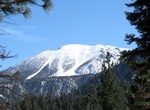
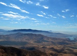
Summit San Gorgonio Mountain, Southern California
San Gorgonio Mountain, also known locally as Mount San Gorgonio, or Old Greyback, is the highest peak in Southern California and the Transverse Ranges at 11,503 feet (3,506 m). It is in the San Bernardino Mountains, 27 miles (43 km) east of the city of San Bernardino and 12 miles (19 km) north-northeast of San Gorgonio Pass. It lies within the San Gorgonio Wilderness,... -
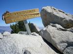
Summit San Jacinto Peak, California
Near the city of Palm Springs, California just east of Los Angeles, Mount San Jacinto rises from the desert floor at near sea level to its 10,834 ft (3,302 meter) peak, the 6th highest mountain peak in the 48 contiguous United States. Although the summit is within close reach when accessed by way of the Palm Spring Aerial Tramway, the mountain presents a number of hik... -
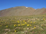
Summit San Luis Peak, La Garita Mountains, Colorado
San Luis Peak is the highest summit of the La Garita Mountains range in the Rocky Mountains of North America. The prominent 14,022-foot (4273.8 m) fourteener is located in the Gunnison National Forest portion of the La Garita Wilderness in Saguache County approximately 10 miles (16 km) north of Creede. It is situated rather far to the east of the other fourteeners in ... -
Hike San Miguel Mountain, Eastlake, California
San Miguel Mountain is about 4.7 miles long and located near Eastlake, California. The trail is great for hiking and normally takes 1-3 hours. This is one of the most challenging hikes I've done in San Diego. They way up is very steep and there aren't any switchbacks. This is a hot hike, as there is no shade, so best to do it on a cool day and start early. Start just ... -
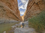
Hike Santa Elena Canyon Trail, Big Bend National Park, Texas
This trail leads into the stunning Santa Elena Canyon. After crossing Terlingua Creek, the trail ascends on paved steps to a vista, then descends back to the water's edge, continuing into the canyon until the canyon walls meet the water. A Big Bend classic. Trail is impassable when Terlingua Creek floods. Trail begins at terminus of the Ross Maxwell Scenic Drive. -
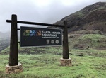
Explore Santa Monica Mountains National Recreation Area, Southern California
The Santa Monica Mountains National Recreation Area (SMMNRA) is a United States National Recreation Area containing many individual parks and open space preserves, located primarily in the Santa Monica Mountains of Southern California. The SMMNRA is located within the greater Los Angeles region, with two thirds of the parklands in northwest Los Angeles County, and the... -
Summit Santanoni Peak, New York
Santanoni Peak is a mountain located in Essex County, New York. The mountain is part of the Santanoni Mountains of the Adirondacks. The mountain's name is believed to be an Abenaki derivative of "Saint Anthony"; the first French fur traders and missionaries having named the area for Saint Anthony of Padua. Santanoni Peak is flanked to the north by Panther Peak, and to... -
Hike Santa Ysabel Open Space Preserve, California
The Santa Ysabel Open Space Preserve has one of the sections of the Coast to Crest Trail. This 7.4 mile one-way trail is strenuous and includes views of cattle ranching and has seperate two loop trails. The West Vista Loop Trail is a moderate 3.8 mile trail. The Kanaka Loop Trail is a strenuous 4.8 mile trail. The Santa Ysabel Preserves are surrounded by oak woodla...
Price: $289.36