Give us feedback!


 See all

Our philosophy is simple. We want to encourage you to dream. BIG! Then we help you plan your trip, get the most out of it while you're traveling and help you share your experience with friends.
Join Now It's FREE
Dream Packages
Duration: 14 hours
Price: $277.07
Price: $277.07
Duration: 9 hours 45 minutes
Price: $129.27
Price: $129.27
Duration: 11 hours 30 minutes
Price: $164.45
Price: $164.45
Duration: 3 hours
Price: $250.00
Price: $250.00
Dreams Still To Do
Checked-Off Dreams
Dreams Still To Do
Checked-Off Dreams
Advertisement
Explore In the Desert
-
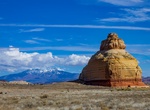
See Church Rock, Utah
Church Rock is a solitary column of sandstone in southern Utah along the eastern side of U.S. Route 191, near the entrance to the Needles District of Canyonlands National Park. With majestic Colorado and Green River canyons, Canyonlands, this 200 foot roadside oddity near Monticello is called Church Rock. It seldom attracts more than a casual glance as visitors h... -
Explore Coal Mine Canyon, Arizona
Known for its spectacular spires, Hoodoos, cliffs, abundant fossils and narrow ravines, Coal Mine Canyon was formed from centuries of erosion of the sandstone and shale from which it was carved by mother-nature. The Canyon presents an other-worldly landscape comprised of colorful rock walls surrounding the plunging canyon that runs for 15 miles (24 kilometers) from it... -
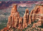
Explore Colorado National Monument, Colorado
Colorado National Monument (locally referred to as The Monument) is near the city of Grand Junction, Colorado. Spectacular canyons cut deep into sandstone and even granite–gneiss–schist rock formations, in some areas. This is an area of desert land high on the Colorado Plateau, with pinion and juniper forests on the plateau. The park hosts a wide range of ... -
Visit Coro & Medanos De Coro National Park, Venezuela (UNESCO site)
Coro (also known as Santa Ana de Coro) is the capital of Falcón State and the oldest city in the west of Venezuela. Since the 1950s Coro has been conserved as a national monument, and in 1993 Coro and its port were designated by UNESCO as a World Heritage Site. However, in 2005 Coro was inscribed in the List of World Heritage Sites in danger . From historic, co... -
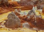
Explore Danakil Desert "Cruelest Place on Earth", Ethiopia
The Danakil Desert lies in the Afar Triangle. It extends into the north-east of Ethiopia, the south of Eritrea and into much of Djibouti. It is known for its extreme heat and inhospitability. The deepest point in the desert lies up to 100 m below sea level in the Danakil Depression. The Danakil Desert's main industry is salt mining that is still cut by hand and loaded... -
Visit Deadvlei (Dead Vlei), Namibia
Deadvlei is a white clay pan located near the more famous salt pan of Sossusvlei, inside the Namib-Naukluft Park in Namibia. Also written DeadVlei or Dead Vlei, its name means "dead marsh" (from Englishdead, and Afrikaansvlei, a lake or marsh in a valley between the dunes). The pan also is referred to as "Dooie Vlei" which is the (presumably original) fully Afrikaans ... -
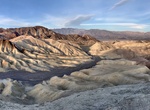
Explore Death Valley National Park, California
Death Valley National Park is a national park located east of the Sierra Nevada in the arid Great Basin of the United States. Parts of the park are in southern Inyo County and northern San Bernardino County in Eastern California, with a small extension into southwestern Nye County and extreme southern Esmeralda County in Nevada. In addition, there is an exclave (Devil... -
Explore Dorob National Park, Namibia
Dorob National Park ("dry land") is a protected area in Erongo, along the central Namibian coast, which is 1,600 kilometres (990 mi) in length. It was gazetted as a national park under the Nature Conservation Ordinance No.4 of 1975 on 1 December 2010, and with Namib-Naukluft Park covers an area of 107,540 square kilometres (41,520 sq mi). The park extends from the Kui... -
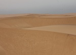
Visit Dune 45 Viewpoint (Sossusvlei), Namibia
Dune 45 is often considered the most photographed dune in the world, due to its close proximity to the road. It's best to go really early when the sun isn't right above you. Definitely worth seeing and hiking up to the top. -
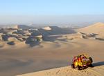
Ride Dune Buggy
A dune buggy is a recreational vehicle with large wheels, and wide tires, designed for use on sand dunes, beaches, or desert recreation. It is called a "Beach Buggy" in the United Kingdom, Ireland and many other English speaking countries. The design is usually a modified vehicle and engine mounted on an open chassis. The modifications usually attempt to increase the ... -
Explore Egypt's Eastern Desert (Arabian Desert)
Eastern Desert, Arabic Al-Saḥrāʾ Al-Sharqiyyah, also called Arabian Desert, is a large desert in eastern Egypt. Originating just southeast of the Nile River delta, it extends southeastward into northeastern Sudan and from the Nile River valley eastward to the Gulf of Suez and the Red Sea. It covers an area of about 85,690 square miles (221,940 square km). The Easte... -
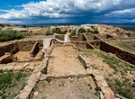
Explore El Morro National Monument, New Mexico
El Morro National Monument is located on an ancient east-west trail in western New Mexico. The main feature of this National Monument is a great sandstone promontory with a pool of water at its base. As a shaded oasis in the western U.S. desert, this site has seen many centuries of travelers. The remains of a mesa top pueblo are atop the promontory where between about... -
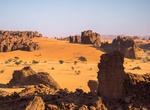
Explore Ennedi Massif, Chad (UNESCO Site)
The Ennedi Plateau, located in the North-East of Chad, in the Ennedi Region, is a sandstone bulwark in the middle of the Sahara. It is assailed by the sands on all sides, that encroach the deep valleys of the Ennedi. Only the caravans manage to cross it and this makes the region an area subject to multiple influences. The landscape has structures like towers, pillars,... -
Explore Erg Chebbi Dunes, Morocco
Erg Chebbi is one of Morocco's two Saharan ergs – large dunes formed by wind-blown sand –. The other is Erg Chigaga near M'hamid. Its distinctive dunes reach a height of up to 150 meters. The composite erg spans an area of 22 kilometers from north to south and up to 5 kilometers from east to west. The nearest sizable town is Erfoud, about 40 kilometers fur... -
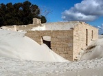
Explore Eucla National Park, Western Australia
Eucla National Park is a national park in Western Australia (Australia), 1,238 kilometres (769 mi) east of Perth. The southern edge of the park borders a section of the Great Australian Bight. Other notable features of the park include Wilson Bluff and Delisser sandhills. The area is composed of mallee scrub and heath vegetaton, typical of the southern coast. Wildflow...


Price: $239.00