Give us feedback!


 See all

Our philosophy is simple. We want to encourage you to dream. BIG! Then we help you plan your trip, get the most out of it while you're traveling and help you share your experience with friends.
Join Now It's FREE
Dream Packages
Duration: 3 days
Price: $560.00
Price: $560.00
Duration: 3 hours
Price: $250.00
Price: $250.00
Duration: 11 hours 30 minutes
Price: $164.45
Price: $164.45
Duration: 14 hours
Price: $277.07
Price: $277.07
Dreams Still To Do
Checked-Off Dreams
Dreams Still To Do
Checked-Off Dreams
Advertisement
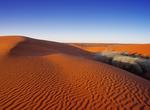
Explore In the Desert
-
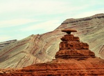
Visit Mexican Hat, Utah
Mexican Hat is a small settlement on the San Juan River in south-central San Juan County, Utah, United States. The name "Mexican Hat" comes from a curiously sombrero-shaped, 60-foot (18 m) wide by 12-foot (3.7 m) thick (18.3 x 3.7 m), rock outcropping on the northeast edge of town. The "Hat" has two rock climbing routes ascending it. It is on U.S. Route 163 just 3 mil... -
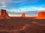
Explore Monument Valley, Utah & Arizona
Monument Valley is a region of the Colorado Plateau characterized by a cluster of vast sandstone buttes, the largest reaching 1,000 ft (300 m) above the valley floor. The valley lies within the range of the Navajo Nation Reservation, and is accessible from U.S. Highway 163. The area is part of the Colorado Plateau. The floor is largely Cutler Red siltstone or its sand... -
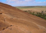
Visit Mount Wudinna, South Australia
Mount Wudinna is located near the locality of Wudinna, South Australia. It is claimed to be the second largest monolith in Australia, Ayers Rock being the largest, with Kokerbin Rock being the third largest. It is listed on the South Australian Heritage Register. -
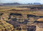
Drive to Muley Point, Utah
Muley Point is a remote, scenic overlook in southern Utah near Mexican Hat. The view provides panoramic vistas of the desert landscape of southern Utah and northern Arizona. Monument Valley is visible in the distance while the San Juan River cuts into the canyon below. It's really worth the effort to get here! This is a peaceful isolated place that has few visitors, ... -
Explore Munga-Thirri National Park (Simpson Desert), South Australia, Australia
Munga-Thirri—Simpson Desert Conservation Park (formerly Simpson Desert Conservation Park and Simpson Desert National Park) is a protected area located in the Australian state of South Australia about 970 kilometres (600 mi) north of the state capital of Adelaide and above 215 kilometres (134 mi) north-east of the town of Oodnadatta. The conservation park occupie... -
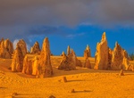
Explore Nambung National Park (The Pinnacles), Western Australia
Nambung National Park is a national park in the Wheatbelt region of Western Australia (Australia), 162 km northwest of Perth. It contains the Pinnacles Desert. Nambung is an Indigenous Australian word meaning crooked or winding referring to the Nambung River that drains into the area. The park is bordered to the north by Southern Beekeepers Nature Reserve and to the s... -
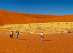
Explore Namib-Naukluft National Park (Namib Desert), Namibia (UNESCO Site)
The Namib Desert is a desert in Namibia and southwest Angola that forms part of the Namib-Naukluft National Park, the largest game reserve in Africa. The name "Namib" is of Nama origin and means "vast place". Having endured arid or semi-arid conditions for at least 55 million years, it is considered to be the oldest desert in the world. The Namib's aridity is caused b... -
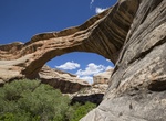
Explore Natural Bridges National Monument, Utah
Natural Bridges National Monument is a U.S. National Monument located about 50 miles (80 km) north west of the Four Corners boundary of southeast Utah, in the western United States, at the junction of White Canyon and Armstrong Canyon, part of the Colorado River drainage. It features the eighth largest natural bridge in the world, carved from the white Permian sandsto... -
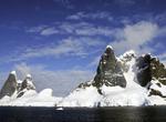
Cruise through Neumayer Channel, Antarctica
Neumayer Channel is a channel 16 miles (26 km) long in a NE-SW direction and about 1.5 miles (2.4 km) wide, separating Anvers Island from Wiencke Island and Doumer Island, in the Palmer Archipelago. The southwest entrance to this channel was seen by Eduard Dallmann, leader of the German 1873-74 expedition, who named it Roosen Channel. The Belgian Antarctic Expedition,... -
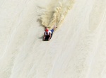
Sandboard Ninety Mile Beach (Gaint Te Paki), North Island, New Zealand
Ninety Mile Beach and its northern dunes, looking much like a desert landscape, are often used for sandboarding. -
Off-road to Nokai Dome, Utah
This is a remote and untouched area of dramatic canyons. Mikes Canyon has long and deep forks that drain into the San Juan River. From route 276, turn south on Nokai Dome Road. Continue on this dirt road for almost 14 miles until you reach an old airstrip that was put in by Shell Oil when it was exploing the area for oil in the past. -
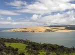
Sandboarding Opononi Sand Dunes, New Zealand
Opononi Sand Dunes are located in the Hokianga region of New Zealand. Activities include sandboarding on either "snowboards" or boogie boards on the dunes. To get to the dunes either take the Hokianga Express (peope ferry) across the harbour and climb the dune towrds East (2.5 km) or drive along the beach in Mitimiti 16 km South and climb the dune at the harbour entr... -
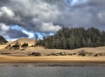
Explore Oregon Dunes National Recreation Area, Oregon
The Oregon Dunes National Recreation Area (or NRA) is located on the Oregon Coast, stretching approximately 40 miles north from the Coos River in North Bend, to the Siuslaw River, in Florence. The NRA is part of Siuslaw National Forest and is administered by the United States Forest Service. The dunes adjoin Honeyman State Park. The Oregon Dunes are a unique area of w... -
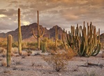
Explore Organ Pipe Cactus National Monument, Arizona
Organ Pipe Cactus National Monument is a U.S. National Monument and UNESCO biosphere reserve located in extreme southern Arizona which shares a border with the Mexican state of Sonora. The park is the only place in the United States where the Organ Pipe Cactus grows wild. Along with Organ Pipe, many other types of cacti, as well as other desert flora native to the Yum... -
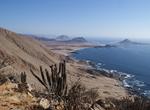
Explore Pan de Azúcar National Park, Chile
Pan de Azúcar National Park in Chile in known for Isla Pan de Azúcar, on which Humboldt Penguins breed on this island. The island can be reached by boat from the mainland but passengers are not allowed to leave the boat. Pan de Azúcar National Park s divided into two ecosystems: the coastal desert of Taltal and the steppe desert of the Sierra Vic...
Price: $139.00