Give us feedback!

Our philosophy is simple. We want to encourage you to dream. BIG! Then we help you plan your trip, get the most out of it while you're traveling and help you share your experience with friends.
Join Now It's FREE
Dreams Still To Do
Checked-Off Dreams
Dreams Still To Do
Checked-Off Dreams
Advertisement
Explore Landmarks (Natural)
-
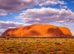
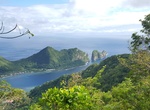
Explore Uluṟu-Kata Tjuṯa National Park (Ayers Rock), Northern Territory, Australia (UNESCO site)
Uluṟu-Kata Tjuṯa National Park is UNESCO World Heritage-listed in the Northern Territory of Australia. It is located 1431 kilometres south of Darwin by road and 440 kilometres south-west of Alice Springs along the Stuart and Lasseter Highways. The park covers 2010 square kilometres and includes the features it is named after - Uluru / Ayers Rock and, 40 kilometres to ... -
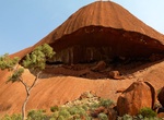
See Uluru Mouth, Uluru-Kata Tjuṯa National Park, Northern Territory, Australia
A section of deep red Ayers rock Uluru looks like a human mouth. -
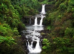
See Umauma Falls, Big Island, Hawaii
The Umauma Falls are located on the Umauma River on the Big Island of Hawaii, approximately 16 miles north of Hilo. They are unique in Hawaii as being a series of three waterfalls in close proximity. They are easily viewed from an overlook located on private botanical garden property accessible for a fee. The overlook was constructed in 1996 by Walter L. Wagner who wa... -
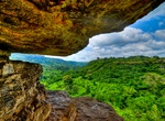
Visit Umbrella Rock, Ghana
The Umbrella Rock is a rock found at the site of the Boti Falls in Yilo Krobo District, Ghana. As the name implies, the overhang on the top is large enough to cover 12 to 15 people at once. Even though the pivot on which the top rock lies on might seem small, it's very strong. Yearly, many Tourists travel to Boti Falls for its natural beauty, and the umbrella rock is ... -
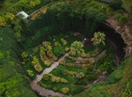
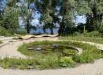
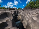
Visit Umpherston Sinkhole (Balumbul), Mount Gambier, South Australia
Umpherston Sinkhole, also known, as The Sunken Garden, was created in 1886, this sunken garden includes viewing platforms, benches, sculptures & walking paths. The sinkhole was created when the top of the chamber collapsed downwards. Now the topsoil down on the floor forms the perfect environment for the sunken garden. -
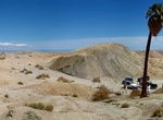
Visit Una Palma, Anza-Borrego Desert State Park, California
Una Palma is located just north of Tule Wash in Anza-Borrego Desert State Park. Use the Cut Across Trail to access or hike from walking over the ridges of the 17 and 5 Palms locations. -
Explore Unga Island, Alaska
Unga Island (Uĝnaasaqax̂ in Aleut) is the largest of the Shumagin Islands off the Alaska Peninsula in southwestern Alaska, United States. The island has a land area of 170.73 sq mi (442.188 km2), making it the 36th largest island in the United States. As of the 2000 census, it had a permanent population of one. Unga Island was formerly named Grekodelarovskoe (Greek De... -
Hike Upper Muley Twist Canyon, Capitol Reef National Park, Utah
Upper Muley Twist Canyon in Capitol Reef National Park offers many options for side trips and off-trail exploring. It includes narrow canyons, expanses of slickrock, large arches, and dramatic vistas from the top of the Waterpocket Fold. It's 15 miles (24.1 km) roundtrip from the Upper Muley Twist Canyon trailhead (best done as an overnight hike). From the Strike Vall... -
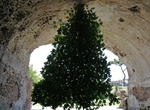
See Upside-Down Fig Tree, Baiae, Naples, Italy
No one is quite sure how this upside-down fig tree in Baiae ended up here or how it survided, but after years is continues to gorw downward and bear figs. It's in the ceiling of the cave adjacent to the Temple of Mercury. Baiae was an ancient Roman town situated on the northwest shore of the Gulf of Naples and now in the comune of Bacoli. -
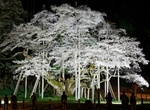
See Usuzumi Zakura, Motosu, Gifu, Japan
Usuzumi Zakura is an ancient cherry tree in Motosu, Gifu, Japan. This tree is another notable example of a long-lived and majestic cherry tree. It is one of Japan's "Five Great Cherry Trees," also known as the "Nihon Godai Zakura," celebrated for their age and beauty. -
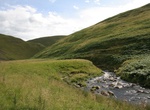
Explore Usway Burn Valley & Cheviot Hills, Northumberland National Park, England
The Usway Burn is an upland river on the southern flanks of the Cheviot Hills, in the Northumberland National Park, England. It is a tributary of the River Coquet and is about 15 km in length. It is located close to the northernmost end of the Pennine Way. The Usway Burn has several tributaries and inlets, including some in the hills far to the north. Cairn Hill, a 77... -
Visit Utopia Island, Almere, Netherlands
Utopia Island is situated nearby to Urban District, and close to Hortus. In order not to miss anything during your visit to Utopia Island, walk the Discovery Route along the agroforestry plot, food forest and schoolyard. -
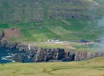
Explore Vágseiði, Faroe Islands
Vágseiði is an area in Vágur, Faroe Islands, located on the west coast of Suðuroy west of the village Vágur, from which it takes its name. Eiði is the Faroese word for Isthmus. The distance between the east and the west coast of Vágur is only one km. There is a lake between the village and Vágseiði, the lake is called... -
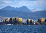
Explore Vaiʻava Strait, American Samoa
Vaiʻava Strait (Samoan:Vāinuʻu o Vaiʻava) is the name of a narrow strait located in Vatia, American Samoa. It is a 250 acres (100 ha) National Natural Landmark. The strait is a great example of cliffs formed by waves (via erosion) on volcanic rock. The strait consists of communal lands. It was designated as a U.S. National Natural Landmark in 1972. Vai'ava Strait sepa... -
Explore Vale da Lua, Goias, Brazil
Vale da Lua is one of the most visited spots in Chapada dos Veadeiros , in the municipality of Alto Paraíso de Goiás (GO). It is a set of rock formations dug in the stones by the rapids of transparent waters of the São Miguel River . It is outside the National Park, in Serra da Boa Vista, in a valley that becomes very dangerous in the rainy season...