Give us feedback!

Our philosophy is simple. We want to encourage you to dream. BIG! Then we help you plan your trip, get the most out of it while you're traveling and help you share your experience with friends.
Join Now It's FREE
Dreams Still To Do
Checked-Off Dreams
Dreams Still To Do
Checked-Off Dreams
Advertisement
Explore Landmarks (Natural)
-
Explore Gunns Plains Cave, Tasmania, Australia
Gunns Plains Cave is a limestone show cave, near Gunns Plains in the North West of Tasmania, twenty kilometres from Ulverstone. The cave was first entered in 1906 by a local Gunns Plains man, Bill Woodhouse, while hunting for possums. A possum eluded him down a hole which led him directly to the cave. This opening served as the original entrance to the cave and early ... -
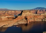
See Gunsight Butte, Lake Powell, Utah
Gunsight Butte is a 4,678-foot (1,426 meter) elevation sandstone summit located in Glen Canyon National Recreation Area, in Kane County of southern Utah. It is situated 12 miles (19 km) northeast of the town of Page. Gunsight Butte is an island that towers nearly 1,000 feet above Lake Powell when the lake is full. This iconic landmark of the Lake Powell area is a butt... -
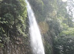
See Gunung Nyawe Waterfalls, Sumatra, Indonesia
Gunung Nyawe falls from a 100m tall cliffs. It's usually accompanied by a beautiful rainbow which you can admire sitting on the rocks nearby. -
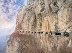
Drive through the Guoliang Tunnel Road, China
The Guoliang Tunnel is carved along the side of and through the Taihang Mountains, in the Hunan Province of China. The tunnel passes through the side of an almost vertical section of a mountain with many holes that looks likes windows. Before the tunnel was constructed, access to the nearby Guoliang village was limited to a difficult path carved into the mountainside.... -
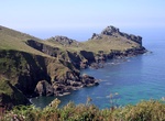
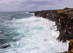
Visit Gurnard's Head, Cornwall, England
Gurnard's Head is a prominent headland on the north coast of the Penwith peninsula in Cornwall, England. The name is supposed to reflect that the rocky peninsula resembles the head of the gurnard fish. Gurnard's Head is the site of basaltic pillow lavas, formed by underwater volcanic eruptions up to 400 million years ago. It is north of the hamlet of Treen in the pari... -
Hike to Gygrestolen, Norway
Gygrestolen is a unique rock formation and a well-known landmark around Bø. The 7km trail is steep and difficult but the top awards with great views of lake Venetjønn and Gygrestolen. -
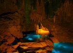
Explore Gyokusendo Illuminated Caves, Okinawa, Japan
The Gyokusendo Illuminated Caves in Okinawa, Japan has a total length of five kilometers is known for its beautiful stalagmites and stalactites. 850 metres of these caves are open to tourists. Blue lamps concealed underwater and external flood lights accentuate the rock features that are formed by a steam that is twisting it’s way through the caverns, as you can... -
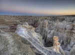
See Gypsum Sinkhole, Capitol Reef National Park, Utah
The Gypsum Sinkhole is an occurrence formed by the reverse of the process that created Glass Mountain. Here groundwater is dissolving a buried gypsum plug. The cavity left behind has collapsed under the weight of overlying rock layers. This collapse has created a large sinkhole nearly 50 feet (15 m) in diameter and 200 feet (61 m) deep. Gypsum Sinkhole is located... -
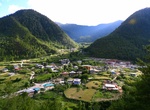
Explore Haa Valley, Bhutan
The Haa Valley is a pristine forested district along Bhutan's western frontier with Tibet. Haa Valley major economic activity is rice production, yak herding and trade with neighbouring China. The place has a religious significance as Lhakhang Karpo and other monasteries are situated there. -
See Hafnarberg Sea Cliffs, Iceland
Hafnarberg is a long line of sheer sea lava cliffs south of the old fishing hamlet of Hafnir. Various marine birds nest at the cliffs. A walk to Hafnarberg is popular among hikers and bird watchers, along a marked path from the road to Reykjanes. -
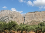
Explore Ha Gorge, Crete, Greece
Ha Gorge is a gorge located on the west slope of Thrypti mountain on the eastern part of the island of Crete in Greece. It is located in the east of Vasiliki village in the plain of Ierapetra. The gorge is about 1.5km long and is narrow at several points with walls rising up to 300m. Being very difficult to access to people, the Ha gorge maintains a rich and dive... -
Tour Ha Ho No Geh Canyon, Arizona
Ha Ho No Geh Canyon is just as spectacular as Cola Mine Canyon and is full of hoodoos and towers. It is usually less visited as Cola Mine Canyon since the 4x4 road is longer and the canyon is entirely within the Hopi Reservation. The upper parts of the canyon seem to be lined by a vertical band of orange/yellow sandstone up to 200 feet high. Blue Canyon, Coal Mine Ca... -
Explore Hains Point, Washington, D.C.
Hains Point is located at the southern tip of East Potomac Park between the main branch of the Potomac River and the Washington Channel in southwest Washington, D.C. The land on which the park is located is sometimes described as a peninsula but is actually an island: the Washington Channel connects with the Tidal Basin north of the park and the Jefferson Memorial. Th... -
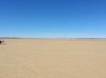
Visit Hakskeenpan Pan, South Africa
Hakskeenpan is a mud and salt pan in the Kalahari Desert, in Southern Africa. It is located in the Mier region in the Northern Cape Province, in South Africa, at 801 meters (2,628 ft) above sea level. The pan covers an area of approximately 140 km2 (54mi2). The present day Kalahari landscape—essentially an inland sand sea sitting within an uplifted sedimentary b... -
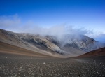
Explore Haleakalā Crater, Maui, Hawaii
Haleakalā is a massive shield volcano that forms more than 75% of the Hawaiian Island of Maui. The western 25% of the island is formed by the West Maui Mountains. The tallest peak of Haleakalā, at 10,023 feet (3,055 m), is Puʻu ʻUlaʻula (Red Hill). From the summit one looks down into a massive depression some 11.25 km (7 mi) across, 3.2 km (2 mi) wide, and nearly...