Give us feedback!

Our philosophy is simple. We want to encourage you to dream. BIG! Then we help you plan your trip, get the most out of it while you're traveling and help you share your experience with friends.
Join Now It's FREE
Dreams Still To Do
Checked-Off Dreams
Dreams Still To Do
Checked-Off Dreams
Advertisement
Explore Landmarks (Natural)
-
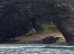
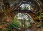
See Honopū Arch, Nāpali Coast, Kauaʻi
Honopu Arch is located at Honopū Valley & Beach along the Nāpali Coast, Kauaʻi. -
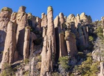
See Hoodoos in Totem Canyon, Chiricahua National Monument, Arizona
See the Hoodoos in Totem Canyon along the Ed Riggs Trail in Chiricahua National Monument. -
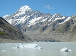
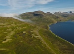
See Hooker Glacier & Lake, New Zealand
Hooker Glacier is one of several glaciers close to the slopes of Aoraki / Mount Cook in the Southern Alps of New Zealand. It is not as large as its neighbour, the Tasman Glacier, measuring 11 kilometres (roughly 6–7 miles) in length. The glacier starts on the south-western slopes of Aoraki/Mt Cook, with its tributaries Sheila Glacier, Empress Glacier, and Noelin... -
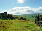
Visit Hookney Tor, Dartmoor, Devon, England
Hookney Tor is a tor, situated on Dartmoor in Devon, England. It lies on the Two Moors Way and remains of Headland Warren farm and Vitifer Mine are also in the valley nearby. Hookney Tor is named after the nearby settlement of Hookner. Hookney Tor is a hill and tor in Dartmoor National Park in South West England. It consists of several granite piles and stands at an e... -
Hike to Hopewell Arch, Kentucky
Hopewell Arch, Double Deer Arch, and Snow Arch is a 2.3 mile trail located near Pine Ridge, Kentucky. Look for all the wild flowers on this moderate out and back trail hike that is considered as moderate. The trail is primarily used for hiking, nature trips, and bird watching and is accessible year-round. -
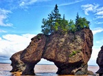
See Hopewell Rocks (Flowerpots Rocks), New Brunswick, Canada
The Hopewell Rocks, also called the Flowerpot Rocks or simply The Rocks, are rock formations caused by tidal erosion in The Hopewell Rocks Ocean Tidal Exploration Site in New Brunswick. They stand between 40-70 feet tall. They are located on the shores of the upper reaches of the Bay of Fundy at Hopewell Cape near Moncton, New Brunswick. Due to the extreme tidal range... -
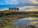
Off-road to Hópsnes, Grindavík, Iceland
A spit next to the town of Grindavík. It was formed during an eruption from a row of craters north of the town (Sundhnúksröðin). Port conditions are good as a result of the lava entering the sea. -
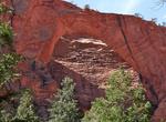
Hike to Hop Valley Trail to Kolob Arch, Zion National Park, Utah
The trail begins off the Kolob Terrace Road and wanders through the open fields with wide open views of the surrounding rock formations. As you near Hop Valley, the trail starts it's descent. The valley floor of Hop Valley is breathtaking with it's flat sandy bottom and vertical walls rising on both sides. The trail is sandy but well worn. The campsites are at th... -
Hike Hornbjarg Cliffs, Hornstrandir Peninsula, Westfjords, Iceland
Hornbjarg Cliffs are enormous cliff at the remote northern tip of the Hornstrandir Nature Reserve in the Westfjörds -
Run Horn Creek Rapid, Colorado River, Grand Canyon, Arizona
Horn Creek Rapid (Level 8) is located at Colorado River Mile 90.8. At lower water, forms very large waves and hydraulics and is one of the most difficult rapids in the canyon requiring a right to left downstream pull to miss a rock ledge on river right. -
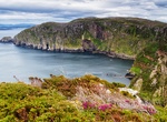
Explore Horn Head, Donegal, Ireland
Horn Head (Irish:Corrán Binne, meaning 'point of the cliff') is a peninsula in northwest County Donegal, Ireland, close to Dunfanaghy. It forms part of Sheephaven Bay. Horn Head has many remains of Neolithic stone circles, court tombs, passage tombs and prehistoric field boundaries. Horn Head cliffs rise straight out of the water to a height of about 180 metres... -
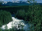
Hike to Horseshoe Falls (Wells Gray Provincial Park), British Columbia, Canada
Horseshoe Falls is one of seven waterfalls on the Murtle River west of Murtle Lake in Wells Gray Provincial Park, east-central British Columbia, Canada. Horseshoe Falls has two steps, 100 m (328 ft) apart; the upper drop is 6 m (20 ft) high and the lower and much wider drop is 10 m (33 ft) high. Horseshoe Falls can be reached by a 14 km (8.7 mi) hiking trail from Pyra... -
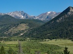
Explore Horseshoe Park, Larimer County, Colorado
Horseshoe Park is a flat at 8,524 feet (2,598 m) in elevation in Larimer County, Colorado. It is within the Rocky Mountain National Park, which lies between Estes Park to the east and Grand Lake, Colorado on the west. Horseshoe Park is home to bighorn sheep, elk and other wildlife, and it is a wetland sanctuary for wide variety of birds. Recreational activities includ... -
See Horsetail Fall at Sunset, Yosemite National Park
Horsetail Fall, located in Yosemite National Park in California, is a seasonal waterfall that flows in the winter and early spring. The fall occurs on the east side of El Capitan. There are a few days every February where this fall is lit up by the setting sun and reflects a bright orange. This waterfall descends in two streams side by side, the eastern one being... -
Explore Horsethief Canyon, Alberta
Horsethief Canyon is found 16 kilometres (9.9 mi) northwest of the town of Drumheller, in Starland County in the province of Alberta, Canada. It is on the east bank of the Red Deer River, along Highway 838 (known locally as North Dinosaur Trail). Both Horsethief Canyon and Horseshoe Canyon are distinctive features of the surrounding badlands of central Alberta. Althou...