Give us feedback!

Our philosophy is simple. We want to encourage you to dream. BIG! Then we help you plan your trip, get the most out of it while you're traveling and help you share your experience with friends.
Join Now It's FREE
Dreams Still To Do
Checked-Off Dreams
Dreams Still To Do
Checked-Off Dreams
Advertisement
Explore Landmarks (Natural)
-
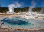
Explore Backcountry Geyser Basins, Yellowstone National Park, Wyoming
The Gibbon, Heart Lake, Lone Star, and Shoshone Geyser Basins are located away from the heavily traveled portions of the park. Some require several miles of off-trail hiking to reach. These areas also generally lack the boardwalks and other safety features of the developed areas. As falling into geothermal features can be fatal, it is usually advisable to visit these ... -
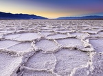
Visit Badwater Basin, Death Valley National Park, California
Badwater Basin is an endorheic basin in Death Valley National Park, Death Valley, Inyo County, California, noted as the lowest point in North America, with an elevation of 282 ft (86 m) below sea level. Mount Whitney, the highest point in the contiguous 48 states, is only 84.6 miles (136 km) to the WNW. The site itself consists of a small spring-fed pool of "bad water... -
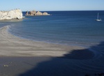
Visit Bahia San Juanico, Sea of Cortez, Baja California Sur, Mexico
San Juanico is an excellent overnight anchorage when traveling between Loreto and Mulege. Loreto is about 22 sea miles to the south, Mulege is about 46 sea miles to the north. This is one of the most attractive yet remote stretches of Baja’s Sea of Cortez. This two mile long bay has an anchorage of Punta Mercenarios on the south end and by the higher sheltering... -
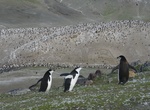
See Baily Head Chinstrap Penguins, Deception Island, Antarctica
Baily Head, a prominent headland forming the easternmost extremity of the island, has been identified as an important bird area (IBA) by BirdLife International because it supports a very large breeding colony of chinstrap penguins (100,000 pairs). The 78 ha (190-acre) IBA comprises the ice-free headland and about 800 metres (0.50 mi) of beach on either side of it. Oth... -
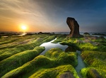
See Ba Khom Stone, Vietnam
Ba Khom stone looks like an old man with a bent back. Some people call it Ca Duoc (eggplant) stone because it has a curved shape like a nightshade fruit. -
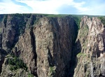
See Balanced Rock (Black Canyon), Arizona
If you’re kayaking or rafting in Black Canyon and you’re going to be near Nevada Falls, make sure to check out this natural feature. How to Get There: Accessible by kayak or raft in Black Canyon. Balanced Rock is just south of Nevada Falls, on the east side of the river. Balanced Rock is only visible when kayaking or rafting down Black Canyon. -
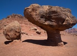
See Balanced Rock (Globe Rock), Tuba City, Arizona
Globe Rock (aka Balanced Rock) and located south of Tuba City a little off Route 264. Rock has a pedestal of one foot diameter supporting a two ton boulder. Best photos in the winter months near sunrise ands sunset. -
See Balanced Rocks near Lee's Ferry, Arizona
While driving on the Honey Moon Trail to Lees Ferry, stop and see the Balanced Rocks. -
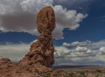
Hike Balanced Rock Trail, Arches National Park, Utah
Balanced Rock is one of the most popular features of Arches National Park. A loop trail at the base of a fragile, picturesque rock formation. Part of the trail is paved and accessible to wheelchairs. The total height of Balanced Rock is about 128 feet (39 m), with the balancing rock rising 55 feet (16.75 m) above the base. The big rock on top is the size of three... -
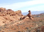
Hike Balanced Rock Trail (Valley of Fire), Nevada
Watch out now! This formation of red sandstone could topple over at any minute. Not really. But it sure looks like it will! Walk this quarter-mile roundtrip trail to see this precarious rock formation. And while you’re at it, check out the nearby visitor center to learn about the park’s geology, animals, and past human inhabitants. Distance: 0.25 roundtri... -
See Balance Rock, Yellowhead Hwy, Haida Gwaii North, BC, Canada
Balance Rock just off the Yellowhead Highway near Skidegate is a feature of Haida Gwaii (Queen Charlotte Islands), British Columbia, Canada. -
See Balancing Rock (Druid's Idol), Brimham Rocks, North Yorkshire, England
Balancing Rock (Druid's Idol or Idol stone) is a rock formation at Brimham Rocks, North Yorkshire, England. -
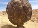
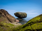
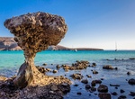
See Balandra Mushroom Rock (El Hongo), La Paz, baja California Sur
Puerto Balandra is home to the famous Mushroom Rock, "El Hongo." Unfortuantely due to storms and people climbing on it it collapsed, but was raised again by volunteers from La Paz. -
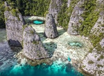
Visit Bal Bulol, Misool Timur, Raja Ampat Regency, Indonesia
Bal Bulol is an incredibly beautiful place with three rocks inside the lagoon, one of which looks like a Christmas tree. -
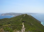
Hike Bald Head Walk Trail, Torndirrup National Park, Western Australia
The Bald Head Walk Trail is a challenging 12.5 km out and back traverse in Torndirrup National Park providing stunning views of the Southern Ocean and King George Sound.