Give us feedback!


 See all

Our philosophy is simple. We want to encourage you to dream. BIG! Then we help you plan your trip, get the most out of it while you're traveling and help you share your experience with friends.
Join Now It's FREE
Dream Packages
Duration: 3 days
Price: $604.38
Price: $604.38
Duration: 12 hours 30 minutes
Price: $164.45
Price: $164.45
Duration: 9 hours
Price: $88.47
Price: $88.47
Duration: 8 hours
Price: $227.92
Price: $227.92
Related Categories
Dreams Still To Do
Checked-Off Dreams
Dreams Still To Do
Checked-Off Dreams
Advertisement
Explore Natural Wonders
-
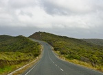
Visit Cape Marathia, Zakynthos Island, Greece
Cape Marathia is the souhernmos point on Zakynthos Island, Greece. -
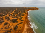
Visit Cape Moreton, Gheebulum Kunungai (Moreton Island) National Park
Cape Moreton is a rocky headland at the north eastern tip of Moreton Island in South East Queensland, Australia. The surrounding area is part of the Moreton Island National Park. Flinders Reef is 5 kilometres (3 mi) north-west of Cape Moreton. The outcrop is mostly composed of sandstone, but also some conglomerate, siltstone and shale. The sand dunes of Moreton Island... -
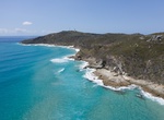
Visit Cape Northumberland, South Australia
Cape Northumberland is a headland in the southeast of the Australian state of South Australia. It is the southernmost point of South Australia. It is located about 3 kilometres (1.9 mi) from the town of Port MacDonnell, 28 kilometres south southwest from the municipal seat of Mount Gambier and about 393 kilometres (244 mi) southeast of the state's capital Adelaide. Ca... -
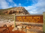
See Cape of Good Hope (Cape Point Nature Reserve), South Africa (UNESCO site)
The Cape of Good Hope is a rocky headland on the Atlantic coast of the Cape Peninsula, South Africa. There is a misconception that the Cape of Good Hope is the southern tip of Africa, because it was once believed to be the dividing point between the Atlantic and Indian Oceans. In fact, the southernmost point is Cape Agulhas, about 150 kilometres (90 mi) to the ea... -
Explore Cape Peron, Western Australia
Cape Peron is a headland at Rockingham, at the southern end of Cockburn Sound in Western Australia. It contains the suburb of Peron. Locally known as Point Peron, the cape is noted for its protected beaches, limestone cliffs, reefs and panoramic views. Officially, "Point Peron" is the designation of a minor promontory on the south side of the cape's extremity. The fea... -
Explore Cape Perpetua, Oregon
Cape Perpetua is a large forested headland projecting into the Pacific Ocean on the central Oregon Coast in Lincoln County, Oregon. The land is managed by the United States Forest Service as part of the Siuslaw National Forest. Cape Perpetua is located about 2 miles (3.2 km) south of Yachats, Oregon, along U.S. Route 101. It is a typical Pacific Northwest headland, fo... -
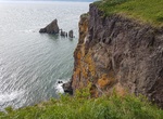
Hike Cape Pillar Track to The Blade, Tasman National Park, Tasmania, Australia
The Blade in Tasman National Park, Tasmania, is a dramatic hiking spot known for its towering cliffs and stunning views of the Southern Ocean. It's located in the Cape Pillar region, offering varied trails suitable for different skill levels. The Blade itself is a knife-edge of rock that provides a unique perspective on the surrounding area, including Tasman Island. -
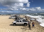
Fish at Cape Point, Hatteras Island, North Carolina
Cape Point is the easternmost beach of Hatteras Island, meaning it stretches out into the ocean further than any other beach in the Outer Banks. It's anexcellent fishing spot. -
Explore Cape Portland, Tasmania, Australia
Cape Portland (indigenous name: Lumaranatana) is both a geographical feature and a locality near the north-eastern tip of Tasmania, Australia. It points west across Ringarooma Bay. It was named after the Duke of Portland by Matthew Flinders during his 1798 circumnavigation of the island in the sloopNorfolkwith George Bass. It is the site of the 67 km2 Cape Portland Im... -
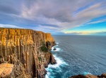
Hike Cape Raoul Track, Tasmania, Australia
Cape Raoul is situated at the southern-most part of the Tasman Peninsula, in south eastern Tasmania. It forms the coastline of Raoul Bay, and is part of the Dolerite landscape of the Tasman National Park. So named from D'Entrecasteaux's pilot. Flinders called it Basaltic Cape, but only prior to the publication of the maps of the French expedition. "In 1814 Flinders ve... -
Explore Cape Reinga, North Island, New Zealand
Cape Reinga is the northwesternmost tip of the Aupouri Peninsula, at the northern end of the North Island of New Zealand. Cape Reinga is more than 100 km north of the nearest small town of Kaitaia. State Highway 1 extends all the way to the cape, but until 2010 was unsealed gravel road for the last 19 km. Suitable vehicles can also travel much of the way via Ninety Mi... -
Visit Cape Saunders, Otago Peninsula, New Zealand
Kaimata, or Cape Saunders, is the prominent headland on the Pacific Ocean coast of Muaupoko, the Otago Peninsula, in the far south-east of Aotearoa New Zealand's Te Wai Pounamu, the South Island. It is home to the Cape Saunders Lighthouse. Captain James Cook sighted the landmark on 25 February 1770, and named it in honour of Admiral Sir Charles Saunders, under whom Co... -
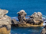
Visit Cape Skamni, Sozopol, Bulgaria
Cape Skamni is right in the Sozopol old town. Clear water to swim and nice rock formations. -
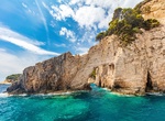
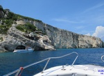
Visit Cape Skinari, Zakynthos Island, Greece
Zakynthos has the shape of an arrowhead, with the "tip" (Cape Skinari) pointing northwest. Numerous natural "blue caves" are cut into cliffs around Cape Skinari; they are accessible only by small boats, which are popular amongst tourists. -
Explore Cape Split, Nova Scotia
Cape Split is a headland located on the Bay of Fundy coast of the Canadian province of Nova Scotia. Cape Split is located in Kings County and is a continuation of the North Mountain range, which is made of tholeiitic basalt. The cape separates the main part of the Bay of Fundy from the Minas Basin, a sub-basin to the east. The cape itself is 7 km (4 mi) long and range...


Price: $137.22