Give us feedback!


 See all

Our philosophy is simple. We want to encourage you to dream. BIG! Then we help you plan your trip, get the most out of it while you're traveling and help you share your experience with friends.
Join Now It's FREE
Dream Packages
Duration: 4 days
Price: $663.61
Price: $663.61
Duration: 14 to 15 hours
Price: $170.10
Price: $170.10
Duration: 2 days
Price: $359.00
Price: $359.00
Duration: 4 days
Price: $772.57
Price: $772.57
Related Categories
Dreams Still To Do
Checked-Off Dreams
Dreams Still To Do
Checked-Off Dreams
Advertisement
Explore Natural Wonders
-
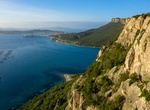
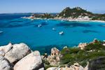
Explore Capo Figari, Sardinia
The coast ofCapo Figari (342m) is characterised by high cliffs. Trails crisscross and lead up to an abandoned lighthouse on the summit, known as il vecchio semaforo (old traffic light). It was from here that Guglielmo Marconi sent the first radio signal to the Italian mainland in 1928. -
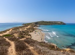
Explore Capo San Marco, Sardinia
Picturesque, unspoiled peninsula featuring white-sand beaches, ancient city ruins & a lighthouse. -
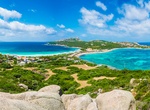
Explore Capo Testa, Sardinia
Cape Testa promontory is connected to the mainland by an isthmus and the structure is situated in the municipality of Santa Teresa di Gallura on the Sea of Sardinia. -
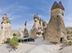
Visit Cappadocia & Göreme National Park, Turkey (UNESCO site)
Fossilized relics of a village that was part of the Byzantine Empire as long ago as the 4th century can be seen in Cappadocia, Turkey at the Goreme National Park, a UNESCO World Heritage Site. The windswept remains of the towering spires, convents, churches, pillars and dwellings blend into the landscape and natural outcroppings of surreal fairy chimney rock formation... -
Visit Caprera Island, Sardinia
Caprera is a small island off the coast of Sardinia, Italy, located in the Maddalena archipelago. The island has been declared a natural reserve for the particular species of seabirds living on it (royal seagull, cormorant and peregrine falcon). The island's name is linked to that of Giuseppe Garibaldi, an Italian patriot and fighter who lived in the 19th century and ... -
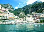
Visit Capri, Italy
The small Italian island of Capri is situated 5 km from the mainland in the Bay of Naples, a celebrated beauty spot and coastal resort since the days of the Roman Republic until now. It is also part of Campania. Capri, known in Greek mythology as the isle of the sirens, was a favored resort of the Roman emperors. Most notoriously, the emperor Tiberius had his villa on... -
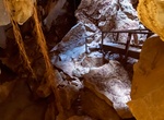
Explore Capricorn Caves, Queensland, Australia
Capricorn Caves are located 23 kilometres (14 mi) north of Rockhampton, Queensland, Australia. It was first discovered in 1882 by a Norwegian migrant John Olsen. He went on to claim the land under a lease hold title and open the attraction publicly in 1884. The property was later reclassified to free hold land and is today one of the largest privately owned caves... -
Visit Caprivi Strip, Namibia
Caprivi, sometimes called the Caprivi Strip, Okavango Strip and formerly known as Itenge, is a narrow protrusion of Namibia eastwards from the Kavango Region about 450 km (280 mi), between Botswana to the south, and Angola and Zambia to the north. Caprivi is bordered by the Okavango, Kwando, Chobe and Zambezi rivers. Its largest settlement is the town of Katima Mulilo... -
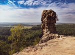
Hike to Čapská Palice, Czech Republic
Sandstone eroded rock formation above forest in CHKO Kokořínsko protected area. Located on Čap - Tschap hill near Duba, Czechia. -
Visit Captain Jack's Stronghold, California
Captain Jack's Stronghold, named for Modoc chief Captain Jack, is a part of Lava Beds National Monument. The stronghold can be accessed from the Perez turnoff, off Highway 139 between Tulelake and Canby, California. During the Modoc War, Captain Jack's band settled here following the Battle of Lost River, and held off a United States Army force outnumbering them by as... -
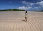
Relax at Captain's Bay, Anguilla
Captain's Bay is a secluded beach on the East End of Anguilla and not easy to get to (the road is a rough ride). Bring a beach umbrella if you want some shade. No beach bars or anything around so bring a cooler with refreshments. -
Visit Capul, Samar Island, Philippines
Capul is a 5th class island municipality in the province of Northern Samar, Philippines. According to the 2015 census, it has a population of 12,679 people. A lighthouse was built on the island which served as a guidepost for the Acapulco-Manila galleon trade vessels passing through the treacherous waters of San Bernardino Strait. It also served as the capital of Sam... -
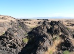
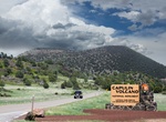
Explore Capulin Volcano National Monument, New Mexico
Capulin Volcano National Monument, located in northeastern New Mexico, was designated a U.S. National Monument on August 9, 1916. It is an example of an extinct cinder cone volcano that is part of the Raton-Clayton Volcanic Field. A paved road spirals around the volcano and visitors can drive up to a parking lot at the rim. Hiking trails circle the rim as well as lead... -
Visit Caramoan, Camarines Sur, Philippines
Caramoan is a first-class municipality in the province of Camarines Sur, Bicol Region, Philippines. It is located at the tip of the Caramoan Peninsula, a rugged place of land extending into the waters of the Maqueda Channel on the north and east and Lagonoy Gulf on the south. Tourist destinations include the Caramoan National Park, the Centro, and Gota Beach, where ac... -
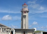
See Carapacho Lighthouse & Ponta da Restinga, Graciosa Island, Azores Islands
The Lighthouse of Carapacho is a beacon/lighthouse located along the cliffs of Ponta da Restinga, near the hamlet of Carapacho, civil parish of Luz on the island of Graciosa, the Portuguese archipelago of the Azores. The 1883Plano Geral de Alumiamento(Illumiation General Plan), proposed the construction of a fourth-order lighthouse, that would flash each minute and ha...
Price: $133.43