Give us feedback!

Our philosophy is simple. We want to encourage you to dream. BIG! Then we help you plan your trip, get the most out of it while you're traveling and help you share your experience with friends.
Join Now It's FREE
Dreams Still To Do
Checked-Off Dreams
Dreams Still To Do
Checked-Off Dreams
Advertisement
Explore Outside the Park
-
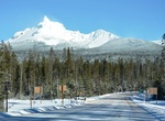
Visit Mount Thielsen Viewpoint, Oregon
Frame this ancient 9,182-foot volcano in your camera lens and you will see why it’s called the "Lightning Rod of the Cascades.” -
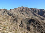
Explore Mount Wilson Wilderness, Arizona
Rugged and sublime landscapes with nothing but the wind and bird songs to break the silence are the main attraction at Mount Wilson Wilderness. Though this wilderness area may look stark and forbidding, it can be deceiving, hiding several dependable year-round springs that support wildlife. Keep your eyes peeled for desert bighorn sheep as well as evidence of old mini... -
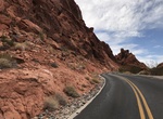
Drive Mouse's Tank Road, Valley of Fire State Park, Nevada
Enjoy a drive through Valley of Fire State Park on Mouse’s Tank Road. Also known as White Domes Road, Mouse’s Tank Road is a paved scenic drive featuring narrow canyons, stunning viewpoints, colorful rocks, petroglyphs and hiking trails. Mouse’s Tank Road forks northward beside the visitor center. This road is only 5.7 miles long, but is one of the m... -
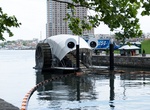
See Mr. Trash Wheel, Baltimore, Maryland
Mr. Trash Wheel, officially called the Inner Harbor Water Wheel, is a trash interceptor, a vessel that removes trash from the Jones Falls river as it empties into the Inner Harbor in Baltimore, Maryland. It is powered by water wheels and solar cells, and places trash from the harbor onto an onboard conveyor belt which routes it into dumpsters on the vessel. Mr. Trash ... -
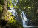
Hike to National Creek Falls, Oregon
An excellent day hike for the whole family! This short trail (0.4 mile) descends through a shaded, mixed conifer forest, ending at the base of the ever-flowing falls. -
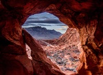
Hike to Natural Arch Trail (Valley of Fire), Valley of Fire State Park, Nevada
For an off-the-beaten-path experience, hike the Natural Arch Trail. This trail takes you through beautiful sandstone formations in an area that most people don’t know about. The trail is rather sandy, which makes it a little more difficult, but the lack of elevation gain makes up for it. Distance: 4.2 miles out and back How to Get There: Coming from the east ent... -
Visit Needles, California
Needles is a city in San Bernardino County, California, United States. It lies on the Needles is a city located on the western banks of the Colorado River in San Bernardino County, California. It is located in Mojave Valley, which straddles the California-Arizona border. The city is accessible via Interstate 40 and U.S. Route 95. The population was 4,830 at the 2000 c... -
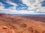
Drive to Needles Overlook, Moab, Utah
An overlook of the Needles section of Canyonlands National Park. Drive 32 miles south from Moab and turn west on the Canyon Rims Road. Drive 17 miles west on this paved road. The Needles Overlook is at the end of the pavement. -
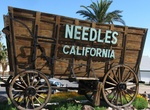
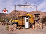
Visit Needles Railroad Borax Wagon, Needles, California
Needles Railroad Borax Wagon is located in Needles, California. -
Visit Nelson, Techatticup Mine & Eldorado Canyon Mine, Nevada
Originally called Eldorado by Spaniards who discovered gold in the area, the town of Nelson had a population of 37 as of 2010. The town was the site of one of the first major gold strikes in Nevada and one of the biggest mining booms in state history. Gold and silver were discovered here, and in the surrounding Eldorado Canyon around 1859. In its heyday, the area esta... -
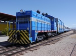
Visit Nevada Southern Railroad Museum (Boulder City), Nevada
If you love trains or have kids that love trains, The Nevada Southern Railway is a fun place to stop. Operated by the Nevada State Railroad Museum, the Nevada Southern Railway is located on the tracks that were installed to support construction at Hoover Dam. The museum operates a heritage railroad, offering passengers 3-minute rides on historic trains. There are also... -
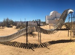
Visit Noah Purifoy Outdoor Desert Art Museum (Noah's Art), Joshua Tree, California
In the late 1980s, Purifoy moved to the Mojave Desert, and over the last fifteen years of his life built what is now the Noah Purifoy Outdoor Sculpture Museum. Located on 10 acres of open land near the town of Joshua Tree, California, the museum contains over one hundred works of art, including large scale assemblages, environmental sculptures, and installation art cr... -
Hike North Fork Trail, Advance, California
North Fork Trail is a 9.5 mile lightly trafficked out and back trail located near Advance, California that features a great forest setting and is good for all skill levels. The trail is primarily used for hiking, walking, nature trips, and birding and is accessible year-round. -
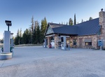
Shop at North Rim Country Store, Arizona
The North Rim Country Store is located along Kaibab Plateau – North Rim Parkway (SR 67) on the North Rim of Grand Canyon National Park. Snacks, groceries, beer and wine, water, maps, souvenirs, camping needs... Even a fill up at the pump - diesel and unleaded gas. And, for your convenience, we have an ATM, tire repair, bulk water and a propane filling stati... -
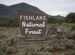
Camp at Oak Creek Campground, Fishlake National Forest, Utah
Oak Creek Campground is to the south of Capitol Reef National Park in the Boulder Mountain area, via Highway 12. Elevation 8,800 feet; 9 sites; drinking water; pit toilets; 30 mi./ 48 km. Campsites are smaller and appropriate for tent camping.