Give us feedback!

Our philosophy is simple. We want to encourage you to dream. BIG! Then we help you plan your trip, get the most out of it while you're traveling and help you share your experience with friends.
Join Now It's FREE
Dreams Still To Do
Checked-Off Dreams
Dreams Still To Do
Checked-Off Dreams
Advertisement
Explore Outside the Park
-
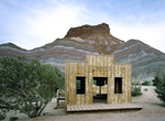
Sleep in Oak Flat Lookout, Sequoia National Forest, California
The Oak Flat Lookout sits the Greenhorn Mountains in the Sequoia National Forest and Sequoia National Monument, about an hour from Bakersfield, California. Perched at an elevation of 4,900 feet, the tower overlooks the scenic Kern River and Kern River Valley and has panoramic views of the mountains, river and valley. Oak Flat Lookout was constructed in 1934 to provide... -
Visit Oakhurst, California
Oakhurst (formerly Fresno Flats) is a census-designated place (CDP) in Madera County, California, United States, 14 miles (23 km) south of the entrance to Yosemite National Park, in the foothills of the Sierra Nevada. At the 2020 census, the population was 5,945, up from 2,829 at the 2010 census. It is part of the Madera metropolitan statistical area. Oakhurst is loca... -
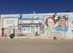
See the Oasis Of Murals, 29 Palms, California
Historic outdoor art gallery displaying the rich heritage of the desert oasis. 25 Murals make up the Oasis of Murals project in 29 Palms. Its fun to find them all and learn about each one. Mural #1: Bill and Frances Keys.Mural #2: Early Life at the Oasis of Mara.Mural #3: Dr. James B. Luckie, "The Father of Twentynine Palms.Mural #4: Our Neighbors in Nature.Mural... -
Attend Orioles Game at Oriole Park at Camden Yards, Baltimore
Seeing a game at Oriole Park is for you whether you’re a Orioles fan or are trying to see a game in each of the 30 MLB parks in the US and Canada. Oriole Park at Camden Yards is a Major League Baseball ballpark located in Baltimore, Maryland. Home field of the Baltimore Orioles, it is the first of the "retro" major league ballparks constructed during the 1990s a... -
Visit Paria, Utah
Paria or Pahreah, is a ghost town on the Paria River in Grand Staircase-Escalante National Monument in central Kane County, Utah, United States. It was inhabited from 1870 to 1929, and later used as a filming location. The area was first settled in 1865 by a Mormon group led by Peter Shirts. This early settlement was namedRockhouse, for Shirts's strongly built sandsto... -
Eat at Peggy Sue's 50's Diner, Yermo, California
Small, 1950s-style diner with American classics such as meatloaf & chicken-fried steak on the menu. -
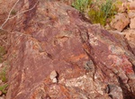
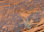
See Petrified Logs (East & West), Valley of Fire State Park, Nevada
If you want a glimpse into our planet’s prehistoric past, you might want to go check out the 150 million-year-old petrified logs in Valley of Fire State Park! Part of a forest of ancient pines that grew here during the time of the dinosaurs, these trees have laid around long enough to become fossils. What does that mean? It means that all the organic parts of th... -
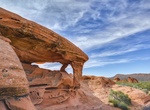
Hike Petroglyph Canyon Trail to Mouse's Tank, Valley of Fire State Park, Nevada
Contrary to what you might think, Mouse’s Tank is not named for the rodents, but for a renegade Paiute Native American who gave settlers and other Native Americans lots of trouble during the 1890s. This canyon was one of his favorite hideouts. The “tank” is a natural basin, or tinaja, that traps and holds water during the long periods between rain. A... -
Hike to Piano Rock, Valley of Fire State Park, Nevada
If you squint, you just might see a piano in this striking sandstone formation. Piano Rock can be reached by way of a short 0.7-mile trail from the Firecave parking area in Valley of Fire State Park. Distance: 0.7 miles How to Get There: After passing the Arch Rock campground on the paved part of Campground Road in Valley of Fire State Park, reset your odometer as yo... -
Visit Pierce's Park, Baltimore, Maryland
Pierce's Park is a one acre urban park in Baltimore's Inner Harbor, honoring local business and community leader Pierce John Flanigan III. -
Visit Pigeon Forge, Tennessee
Pigeon Forge is a mountain resort city in Sevier County, Tennessee, in the southeastern United States. As of the 2010 census, the city had a total population of 5,875. Situated just 5 miles (8 km) north of Great Smoky Mountains National Park, Pigeon Forge is a tourist destination that caters primarily to Southern culture and country music fans. The city's attractions ... -
Visit Pima Air & Space Museum, Tucson, Arizona
The Pima Air & Space Museum, located in Tucson, Arizona, is one of the world's largest non-government funded aerospace museums. The museum features a display of nearly 300 aircraft spread out over 80 acres (320,000 m²) on a campus occupying 127 acres (610,000 m²). It is also, since 1991, home to the Arizona Aviation Hall of Fame. Opened to the public in ... -
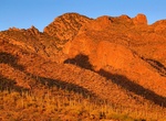
Hike Pima Canyon Trail (Tucson), Arizona
Pima Canyon is a major canyon located in the Santa Catalina Mountains, north of Catalina Foothills and Tucson, Arizona, USA. Pusch Ridge forms the northwestern cliffs of Pima Canyon, dramatically rising from Pima Creek on the canyon floor. Pima Canyon varies greatly in elevation, from 2,900 feet (880 m) above sea level at Pima Creek to 6,350 feet (1,940 m) at Pima Sad... -
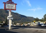
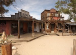
Visit Pioneertown, California
Pioneertown, California, is an unincorporated community in the Morongo Basin region of southern California's Inland Empire Metropolitan Area, on Pioneertown Road at Route 62 in the town of Yucca Valley. The winding, 4-mile (6.4 km) drive northwest to Pioneertown has been designated a California Scenic Drive. The town started as a live-in Old West motion-picture set, b... -
Camp at Pleasant Creek Campground, Dixie National Forest, Utah
Pleasant Creek Campground is to the south of Capitol Reef National Park in the Boulder Mountain area, via Highway 12. Elevation 8,800 feet; 19 sites; drinking water; pit toilets; 28 mi./46 km.