Give us feedback!

Our philosophy is simple. We want to encourage you to dream. BIG! Then we help you plan your trip, get the most out of it while you're traveling and help you share your experience with friends.
Join Now It's FREE
Related Categories
- Arizona State Parks
- Australian National Parks & Reserves
- Canada Provincial Parks
- Canadian National Parks
- New Zealand National Parks
- Parks & Reserves
- South African National Parks
- UK National Parks
- UNESCO Parks & Preserves
- US Historical Parks (NHP)
- US National Parks
- US Parks & Landmarks
- US State Parks
Dreams Still To Do
Checked-Off Dreams
Dreams Still To Do
Checked-Off Dreams
Advertisement
Explore Parks
-
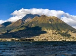
Explore Imbabura Volcano Geopark, Ecuador
Imbabura is an inactive stratovolcano in northern Ecuador. Although it has not erupted for at least 14,000 years, it is not thought to be extinct. Imbabura is intermittently capped with snow and has no permanent glaciers. Covered in volcanic ash, the slopes of Imbabura are especially fertile. In addition to cloud forests, which are found across the northern Andes to a... -
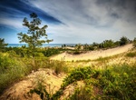
Visit Imperial Sand Dunes Recreation Area (Algodones Dunes, Glamis), California
The Imperial Sand Dunes Recreation Area (Algodones Dunes) is a large erg (sand dune field) located in the southeastern portion of the U.S. state of California, near the border with Arizona and the Mexican state of Baja California. The field is approximately 45 miles long by 6 miles wide and extends along a northwest-southeast line that correlates to the prevailing nor... -
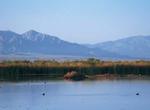
Birding at Imperial Wildlife Area Wister Unit, Salton Sea, California
Imperial Wildlife Area is approximately 7,900 acres of salt marshes, freshwater ponds, and desert scrub. Levees and canals form terraces between seasonally flooded ponds and fields. There are also roads throughout the area. Abundant waterfowl and shorebirds can be found here, as well as the endangered desert pupfish. Units include: Wister, Finney-Ram... -
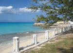
Visit Inagua Islands, Bahamas
Inagua is the southernmost district of the Bahamas comprising the islands of Great Inagua and Little Inagua. Great Inagua is the third largest island in The Bahamas at 596 sq mi (1544 km²) and lies about 55 miles (90 km) from the eastern tip of Cuba. The island encloses several lakes, most notably the 12-mile (19 km) long Lake Windsor (also called Lake Rosa) wh... -
Birding at Inagua National Park, Bahamas
Inagua National Park is a national park on the island of Great Inagua in The Bahamas. It was established in 1965 and has an area of 183,740 acres (744 km2). From as far back as 1904 there was rising concern about the West Indian Flamingo populations. During the 1960s the Bahamas National Trust formed the Inagua National Park. The Inagua National Park is the where the ... -
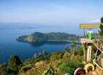
Visit Indah Simarjarunjung Hill, Sumatra, Indonesia
Indah Simarjarunjung Hill is a nicely located viewpoint where you can admire Lake Toba. There are many spots for taking pictures with friends or family. -
Camp at Independence Creek Campground, California
This small, family friendly campground is located on the banks of Independence Creek, just a half mile outside the town of Independence, the Inyo County seat. The Eastern California Museum is nearby, and the Manzanar Japanese American Internment Camp, which is now a National Historic Site, is just six miles away. The gentle stream is regularly stocked with trout, and ... -
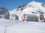
Visit Independence Mines, Palmer, Alaska
The Independence Mines, now Independence Mine State Historic Park, is the site of a former gold mining operation in the Talkeetna Mountains, across Hatcher Pass from Palmer, Alaska. The area's mining history dates to at least 1897, when active claims were reported in the vicinity of Fishook Creek. These early mining efforts were eventually joined to form the Wasilla M... -
Visit Independence National Historical Park, Philadelphia, Pennsylvania (UNESCO site)
Independence National Historical Park is a United States National Historical Park in Philadelphia that preserves several sites associated with the American Revolution and the nation's founding history. Independence Hall is the centerpiece of Independence National Historical Park located on Chestnut Street between 5th and 6th Streets. Known primarily as the location wh... -
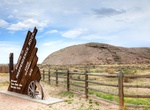
Visit Independence Rock, Wyoming
Independence Rock is a large granite rock, approximately 130 feet (40 m) high, 1,900 feet (580 m) long and 850 feet (260 m) wide, in southwestern Natrona County, Wyoming, along Wyoming Highway 220. During the middle of the 19th century, the rock was a prominent and well-known landmark on the Oregon, Mormon and California emigrant trails. Many of these emigrants carved... -
Visit Independence Visitor Center, Philadelphia, Pennsylvania
The Independence Visitor Center is the Official Visitor Center for the Greater Philadelphia Region, located in Independence National Historical Park at 599 Market Street, One North Independence Mall West (the corner of 6th and Market Streets), in Philadelphia, PA 19106. The 50,000-square-foot (4,600 m2) building was constructed in 2001 as the result of a cooperative e... -
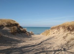
Explore Indiana Dunes National Park, Indiana
Indiana Dunes National Park is a unit of the National Park System designated as a U.S. National Park located in northwest Indiana and managed by the National Park Service. It was authorized by Congress in 1966 as the Indiana Dunes National Lakeshore, the name by which it was known until 2019. The national park runs for nearly 25 miles (40 km) along the southern shore ... -
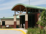
Visit Indiana Dunes National Park Visitor Center, Porter, Indiana
Exhibits, activity room & bookstore -
Explore Indiana Dunes State Park, Indiana
Indiana Dunes State Park is an Indiana State Park located 47 miles (75.6 km) east of Chicago, Illinois, United States. The park is bounded by Lake Michigan to the northwest, and is surrounded in the east, south and west by the Indiana Dunes National Lakeshore, a unit of the National Park Service. The 1,530 acres (619.2 ha) Dunes Nature Preserve makes up the bulk of ea... -
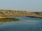
Explore Indian Battle Park, Lethbridge, Alberta
Indian Battle Park is a park located in the Oldman River valley urban park system of Lethbridge, Alberta. The 150-acre (0.61 km2) park was developed in 1960 and commemorates the Battle of the Belly River held in the area on 24 October 1870 between the Blackfoot and the Cree. A formal peace treaty between the two nations was reached in 1871. In 2005, a city council bid...