Give us feedback!

Our philosophy is simple. We want to encourage you to dream. BIG! Then we help you plan your trip, get the most out of it while you're traveling and help you share your experience with friends.
Join Now It's FREE
Related Categories
- Arizona State Parks
- Australian National Parks & Reserves
- Canada Provincial Parks
- Canadian National Parks
- New Zealand National Parks
- Parks & Reserves
- South African National Parks
- UK National Parks
- UNESCO Parks & Preserves
- US Historical Parks (NHP)
- US National Parks
- US Parks & Landmarks
- US State Parks
Dreams Still To Do
Checked-Off Dreams
Dreams Still To Do
Checked-Off Dreams
Advertisement
Explore Parks
-
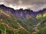
Explore Laurisilva Forest of Madeira, Portugal (UNESCO site)
Laurisilva or laurissilva ("laurel forest") is a subtropical or mild temperate forest, found in areas with high humidity and relatively stable and mild temperatures. They are characterized by tree species that look alike with leaves of lauroide type, evergreen, glossy-leaved trees. The members of the Laurel family (Lauraceae) could be prominent, or in association. The... -
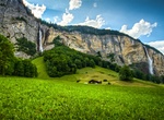
Explore Lauterbrunnen Valley, Switzerland
The Lauterbrunnen Valley in Switzerland is is a deep cleft cut in the topography running between steep limestone precipices. The valley comprises the villages Lauterbrunnen, Wengen, Mürren, Gimmelwald, Stechelberg and Isenfluh. Lauterbrunnen lies at the bottom of a hanging or U-shaped valley that extends south and then south-westwards from the village to meet the... -
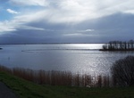
Explore Lauwersmeer National Park, Netherlands
Lauwersmeer National Park (Nationaal Park Lauwersmeer) is a national park in the provinces of Friesland and Groningen in the Netherlands. It consists of the southern and eastern parts of the Lauwersmeer (previously Lauwerszee). In the north of the Netherlands, the Lauwers river forms part of the east-west border between the provinces of Friesland and Groningen. The La... -
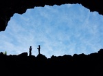
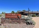
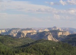
Explore Lava Beds National Monument, California
Lava Beds National Monument is located in northeastern California, in Siskiyou and Modoc Counties. The Monument lies on the northeastern flank of the Medicine Lake Volcano, with the largest total area covered by a volcano in the Cascade Range. Lava Beds National Monument has numerous lava tube caves, with 25 having marked entrances and developed trails for public acce... -
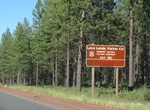
Visit Lava Beds Visitor Center, Lava Beds National Monument, California
Lava Beds is home to one visitor center located at the south end of the park, near cave loop road. An entrance station is located at the north end of the park, but is only open in the summer. As you drive through the park you can find information kiosks with park maps at Petroglyph Point, and Gillem's Camp. Lava Beds National Monument is always open to visitors. Lav... -
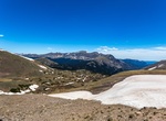
Visit Lava Cliffs Overlook, Rocky Mountain National Park, Colorado
Cinematic point overlooking cliffs of lava formed millions of years ago from volcanic rifts. -
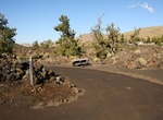
Camp at Lava Flow Campground, Craters of the Moon National Monument, Idaho
Lava Flow Campground campsites are surrounded by a young lava flow near the visitor center.Availability: Mid-April - November (Weather dependent)The campground has 42 sites on a first come-first served basis; no reservations are accepted. Facilities: water (in season) restrooms charcoal grills picnic tables Sites #34, 35, 42 & 3 are fully accessible. Site ... -
Visit Lava Lands Visitor Center, Newberry National Volcanic Monument, Oregon
Lava Lands Visitor Center is the interpretive hub of Newberry National Volcanic Monument. Friendly rangers will help orient you to the Monument using our 3D topographic map.Visit our state of the art interpretive exhibit on area geologic and cultural history, shop in the Discover Your Forest Bookstore, view a variety of films scheduled daily, walk the Trail of Molten ... -
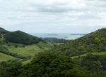
Explore La Vallée de Ferney, Mauritius
La Vallée de Ferney is a forest and wildlife reserve situated in the Bambou mountains north of Mahébourg in Grand Port District, Mauritius. It is managed by the Vallée de Ferney Conservation Trust. Vallée de Ferney is mostly composed of partially rehabilitated rainforests, with a large number of plant species, most of which are endangered o... -
Camp at Lava Point Campground, Zion National Park
Lava Point Campground is open June through October, as weather allows. Situated at 7890 feet above sea level, it is off the Kolob Terrace Road, 25 miles (45 minutes) north of the town of Virgin. It takes approximately one hour and 20 minutes to drive to the campground from the South Entrance of Zion Canyon.There are 6 primitive campsites available first-come, fir... -
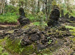
Visit Lava Tree State Monument, Big Island, Hawaii
Lava Tree State Monument is a public park located 2.7 miles (4.3 km) southeast of Pāhoa in the Puna District on the island of Hawaii. It preserves lava molds of the tree trunks that were formed when a lava flow swept through a forested area in 1790. Features A 0.7-mile (1.1 km) foot path forms a loop through the park. Like all Hawaii state parks, there is no charge fo... -
Boat-In Camp at Lava Wall, Ripper’s Cove or Paradise Cove, Catalina, California
Ripper's Cove is located 8.6 miles from Avalon and 4 miles from Two Harbors. Ripper's has 3 campsites. Campsite 1 is on the east side and on the beach, so watch the tides if picking this site. Campsite 2 is the best campsite. It offers some shade from several large pine trees and a nice picnic table. Campsite 3 is furthest west and is a large space but there is no sha... -
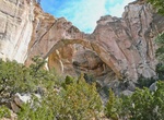
See La Ventana Arch, El Malpais National Conservation Area, New Mexico
La Ventana Arch is one of the largest sandstone arches in New Mexico can be found just 18 miles south of the interstate. A 1/2 mile trail leads to a viewpoint of the arch. The trail leading up to the base of the arch is primitive. The arch is located about 9 miles south on SR 117 from the BLM Ranger Station (which is located 9 miles south of 1-40 on Highway 117). The... -
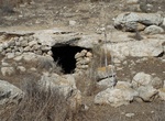
Visit Lavnin Ridge Nature Reserve and Park, Israel
Lavnin is a late Bronze Age archaeological site situated in Israel's Adullam region, rising some 389 metres (1,276 ft) above sea level. The site lies 8 kilometres (5.0 mi) northwest of Beit Gubrin, and about 1 kilometer west, north-west of Khirbat Umm Burj, directly north of Nehusha. In April 2019, the Jerusalem District Planning and Building Committee announced that ... -
Explore Lavreotiki Geopark, Greece
Lavreotiki Geopark is located 60 km drive-distance from Athens and is known around the world for the silver that is extracted from mixed sulfide deposits. It includes approximately 1000 mining sites and the same number of wells and 22 geosites.