Give us feedback!

Our philosophy is simple. We want to encourage you to dream. BIG! Then we help you plan your trip, get the most out of it while you're traveling and help you share your experience with friends.
Join Now It's FREE
Related Categories
- Arizona State Parks
- Australian National Parks & Reserves
- Canada Provincial Parks
- Canadian National Parks
- New Zealand National Parks
- Parks & Reserves
- South African National Parks
- UK National Parks
- UNESCO Parks & Preserves
- US Historical Parks (NHP)
- US National Parks
- US Parks & Landmarks
- US State Parks
Dreams Still To Do
Checked-Off Dreams
Dreams Still To Do
Checked-Off Dreams
Advertisement
Explore Parks
-
Explore Los Katíos National Park, Colombia (UNESCO site)
Los Katíos National Park (Spanish: Parque Nacional de Los Katíos) is a national park located in northwest Colombia. It is a part of the Darién Gap, shared by Panama and Colombia and is contiguous to Darién National Park in Panama. The Pan-American Highway when completed as proposed will pass near or through Los Katíos National Park. ... -
Explore Los Llanos, Colombia & Venezuela
Los Llanos ("The Plains") is a vast tropical grassland plain situated to the east of the Andes in Colombia and Venezuela, in northwestern South America. It is an ecoregion of the flooded grasslands and savannas biome. The Llanos' main river is the Orinoco, which forms part of the border between Colombia and Venezuela and is the major river system of Venezuela. During ... -
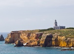
See Los Morrillos Light, Puerto Rico
Los Morrillos Light, also known as Faro Los Morrillos de Cabo Rojo, is a historic lighthouse located in the municipality of Cabo Rojo, Puerto Rico. Located at the southwestern tip of the island of Puerto Rico, this lighthouse was constructed in 1882 in order to guide passing ships through the southeast entrance from the Caribbean Seathrough the treacherous Mona Passag... -
Explore Los Nevados National Natural Park, Colombia
Los Nevados National Natural Park is a national park located in the Cordillera Central of the Colombian Andes. The 5,300-metre-high (17,400 ft) volcano Nevado del Ruiz dominates Los Nevados. Out of the 55 protected areas in Colombia, Los Nevados National Natural Park was the third most visited in 2009, with 50,045 visitors. The most visited was the Rosario and San Ber... -
Explore Los Padres National Forest, California
Los Padres National Forest is a United States national forest in southern and central California. Administered by the United States Forest Service, Los Padres includes most of the mountainous land along the California coast from Ventura to Monterey, extending inland. Elevations range from sea level to 8,847 feet (2,697 m). The forest is approximately 1,950,000 acres (... -
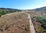
Hike or Mountain Bike Los Peñasquitos Canyon Preserve, San Diego, California
Los Peñasquitos Canyon Preserve is an urban park in San Diego, California. Stretching approximately 7 miles (11 km), the park encompasses some 4,000 acres (16 km2) of both Peñasquitos and Lopez canyons, and is one of the largest urban parks in the United States. There are trails on the south and north side of the creek along with severla crossing points ... -
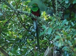
Explore Los Quetzales National Park, Costa Rica
Los Quetzales National Park, (LQNP) located 97 kilometers from San Isidro de El General, Costa Rica, was created in 2005. Stretching across 5,000 hectares (12,000 acres), the national park has limited facilities including a small ranger station and a single, highly mountainous main road. The park predominantly protects cloud forest and is named for the Resplendent Que... -
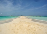
Visit Los Roques Islands National Park, Venezuela
The Los Roques islands are a federal dependency of Venezuela, consisting of about 350 islands, cays or islets. The archipelago is located 80 miles (128 km) directly north of the port of La Guaira, and is a 40-minute flight. Being almost an untouched coral reef, it attracts many "high-end" visitors, especially from Europe, some of which come in their own yachts and an... -
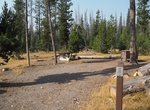
Camp at Lost Claim Campground, Tuolumne County, California
Lost Claim Campground is a rustic campground located on a mixed conifer forested site adjacent to Highway 120. Each site has a picnic table and a campfire pit with a grill. Vaulted toilets, potable water at pump. -
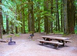
Camp at Lost Creek Campground (Crater Lake), Oregon
Lost Creek Campground is a small, tents-only campground located on the road to Pinnacles Overlook, three miles from the rim of Crater Lake. It usually opens in early July and closes in mid-October. Registration is self-service, and reservations are not available. In July and August, the campground typically fills by mid-afternoon. Each site has a picnic table and bea... -
Camp at Lost Creek Campground (Mount Hood), Oregon
Lost Creek Campground is a fully accessible campground allowing anyone access to campsites, fishing and a paved nature trail that meanders through the area. The campground is also near the Wild and Scenic Sandy River and not far from the popular Ramona Falls Trailhead. Mt. Hood is just southeast of the campground and is close enough for visitors to enjoy a day trip an... -
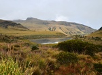
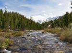
Explore Lost Creek Wilderness, Colorado
The Lost Creek Wilderness is a 119,790-acre (485 km2) wilderness area located in central Colorado in Jefferson and Park counties south of the town of Bailey. The area is situated entirely within the boundaries of the Pike National Forest. The Lost Creek Scenic Area in the Wilderness is a 16,798 National Natural Landmark designated site. The area is named for Lost Cree... -
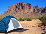
Camp at Lost Dutchman Campground, Arizona
The campground has 134 sites: 68 sites with electric (50/30/20 amp service) and water and the remainder non-hookup sites on paved roads for tents or RVs. Every site has a picnic table, barbecue grill, and a fire pit. There are no size restrictions on RVs. Well-mannered pets on leashes are welcome, but please pick after your pets. Campsite reservations are available o... -
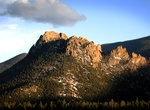
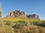
Explore Lost Dutchman State Park, Arizona
The Lost Dutchman Gold Mine (also known by many similar names) is, according to legend, a very rich gold mine hidden in the southwestern United States. The location is generally believed to be in the Superstition Mountains, near Apache Junction, east of Phoenix, Arizona. There are also theories that the mine lies a considerable distance beyond the Superstition Mountai... -
Picnic at Lost Dutchman State Park, Arizona
The Cholla Group ramada can be reserved by groups of 12 or more up to 12 months in advance. It has 4 tables under a large roof with lights, electricity, nearby water spigot, grills and a fire pit. A non-refundable $5.00 reservation fee and a $25 facility use fee applies to use the ramada. All vehicles must pay the day use entry fee. The ramada area has superb views of...