Give us feedback!

Our philosophy is simple. We want to encourage you to dream. BIG! Then we help you plan your trip, get the most out of it while you're traveling and help you share your experience with friends.
Join Now It's FREE
Related Categories
- Arizona State Parks
- Australian National Parks & Reserves
- Canada Provincial Parks
- Canadian National Parks
- New Zealand National Parks
- Parks & Reserves
- South African National Parks
- UK National Parks
- UNESCO Parks & Preserves
- US Historical Parks (NHP)
- US National Parks
- US Parks & Landmarks
- US State Parks
Dreams Still To Do
Checked-Off Dreams
Dreams Still To Do
Checked-Off Dreams
Advertisement
Explore Parks
-
Birding at Malheur National Wildlife Refuge, Oregon
Malheur National Wildlife Refuge is located roughly 30 miles south of the town of Burns, Oregon. The refuge area is roughly T shaped with the southernmost base at Frenchglen, the left top at Malheur Lake and the right top at Harney Lake. Named for an early pioneer, the refuge is a hotspot for birding, fishing and hiking. Numerous wildlife occurs in the area, with as m... -
Explore Malibu Creek State Park, California
Malibu Creek State Park is a state park of California, United States, preserving the Malibu Creek canyon in the Santa Monica Mountains. The 8,215-acre (3,324 ha) park was established in 1974. Opened to the public in 1976, the park is also a component of Santa Monica Mountains National Recreation Area. Malibu Creek State Park stretches from below Malibou Lake in the we... -
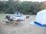
Camp at Malibu Creek State Park Campground, Malibu Creek State Park, California
Malibu Creek State Park Campground has 63 sites and is located in a beautiful canyon about 25 miles north of downtown Los Angeles. Reservations: Select campsites are now part of California State Park’s monthly Reservation Draw program! As a lottery-style system, this program offers all visitors an equal chance to apply for reservations every month. Showers: The ... -
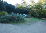
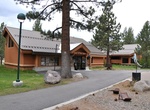
Visit Malibu Creek State Park Visitor Center, Malibu Creek State Park, California
Malibu Creek State Park Visitor Center is only open on the weekends for 4 hours. Lots of natural history and info about the Chumash people and there are some pieces of props from the MASH site on the porch. Dogs are allowed only in the campground, day-use picnic areas, parking lots and paved park roads. Dogs are not allowed on park dirt roads or hiking trails. -
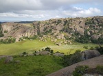
Explore Malolotja National Park, Eswatini
Malolotja National Park covers 18,000 hectares (44,000 acres) of mountain wilderness on Eswatini's northwestern border with South Africa. The park includes Ngwenya Mountain, Eswatini's second highest mountain (1,829 m), and Malolotja Falls which drop 89 metres (292 ft), the highest in Eswatini. Habitats include short grassland to thick riverine scrub, bushveld an... -
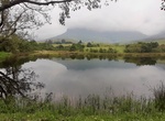
Explore Maloti-Drakensberg Park, South Africa & Lesotho (UNESCO site)
Maloti-Drakensberg Park was established on 11 June 2001 by linking the Sehlabathebe National Park in the Kingdom of Lesotho and the uKhahlamba Drakensberg Park in KwaZulu-Natal, South Africa. The highest peak is Thaba Ntlenyana rising to 3.482 m. The merged park includes Golden Gate Highlands National Park, QwaQwa National Park and Sterkfontein Dam Nature Reserve, (Fr... -
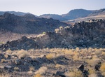
Explore Malpais Mesa Wilderness, California
The long, north-south oval of Malpais Mesa (2,300 feet) stands dominant in the middle of this Wilderness area perched at the southern end of the Inyo Mountains. Rugged valleys, deep canyons, sheer mountainsides, and smaller mesas can all be found within close proximity. From Death Valley National Park in the east, the bajada rises gradually to the mesa's summit; the t... -
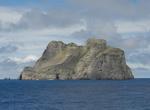
Visit Malpelo Island, Colombia (UNESCO site)
Malpelo Island (Isla de Malpelo) is an island located 235 miles (378 km) from Colombia's Pacific coast, and approximately 225 miles (362 km) from Panama's coast. It has a land area of 0.35 square kilometres (86 acres). It is uninhabited except for a small military post manned by the Colombian Army, which was established in 1986. Visitors need a written permit from the... -
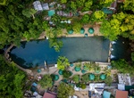
Explore Malumpati Spring & Bugang River, Panay Island, Philippines
Malumpati Spring & Bugang River are one of the most beautiful features in western Visayas. The river starts somewhere in the middle of the jungle and has perfectly clear, tourquoise water. It’s named a spring but it might be an underground river, given the volume of water and number of caves in the region. -
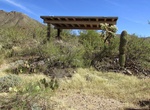
Visit Mam-A-Gah Picnic Area, Saguaro National Park, Arizona
Mam-A-Gah Picnic Area is located where King Canyon and Sendero Esperanza Trails merge - 1 mile from the King Canyon Trailhead -
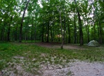
Camp at Mammoth Cave Campground, Mammoth Cave National Park, Kentucky
Mammoth Cave Campground puts campers in a prime spot to explore the depths and overland treasures of Mammoth Cave National Park. Mammoth Cave is an underground passageway containing more than 390 miles of naturally sculpted limestone and sandstone. It is the longest recorded cave system in the world. The grand-scale chambers and long, winding passageways were the insp... -
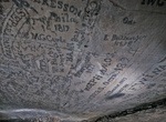
Explore Mammoth Cave National Park, Kentucky (UNESCO site)
Mammoth Cave National Park is a U.S. National Park in central Kentucky, encompassing portions of Mammoth Cave, the longest cave system known in the world. The official name of the system is the Mammoth-Flint Ridge Cave System for the ridge under which the cave has formed. The park was established as a national park on July 1, 1941. It became a World Heritage Site on O... -
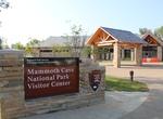
Visit Mammoth Cave National Park Visitor Center, Kentucky
The park Visitor Center is the central point for visitors to orient themselves to what lies both above and below the surface at Mammoth Cave. Situated just up the hill from the cave's Historic Entrance, the Visitor Center is the departure point for all cave tours, and offers exhibits to prepare you for discovery. You can also meet a ranger for a talk or a hike. Gifts,... -
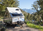
Camp at Mammoth Hot Springs Campground, Yellowstone National Park, Wyoming
Our only year-round campground, Mammoth is located five miles south of Gardiner, Montana and the park's North Entrance. Situated in a high sage brush steppe above the Gardner River, scattered juniper and Douglas fir trees provide shade during hot summer months. Each campsite has a picnic table and fire pit with grate. Food storage boxes measuring 48 x 22 x 2... -
Visit Mammoth Lakes Welcome Center, Mammoth Lakes, California
Located within the Inyo National Forest, it is operated by the US Forest Service, National Park Service and Mammoth Lakes Tourism, which means it’s a one-stop shop for visitors. Purchase books, maps, or art from local artists and much more. Obtain wilderness and fuelwood permits, or purchase Interagency Passes. Information available on history, wildlife, ge...