Give us feedback!

Our philosophy is simple. We want to encourage you to dream. BIG! Then we help you plan your trip, get the most out of it while you're traveling and help you share your experience with friends.
Join Now It's FREE
Related Categories
- Arizona State Parks
- Australian National Parks & Reserves
- Canada Provincial Parks
- Canadian National Parks
- New Zealand National Parks
- Parks & Reserves
- South African National Parks
- UK National Parks
- UNESCO Parks & Preserves
- US Historical Parks (NHP)
- US National Parks
- US Parks & Landmarks
- US State Parks
Dreams Still To Do
Checked-Off Dreams
Dreams Still To Do
Checked-Off Dreams
Advertisement
Explore Parks
-
Visit North Point Park, Cambridge, Massachusetts
North Point Park is an 8.5-acre (3.4 ha) park located on the Charles River in Cambridge, Massachusetts, created as mitigation for the taking of planned parkland for the construction of the Big Dig. The park opened in December 2007. It is part of the "lost half mile" of the Charles River, between the 1910 Charles River Dam, now the site of the Museum of Science and the... -
Camp at North Rim Campground, Grand Canyon National Park, Arizona
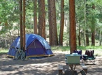
Great Reviews, Sites are spacious and well shaded. Restrooms are clean. The campstore carries fresh fruit, produce, sells soft serve ice cream and all sorts of groceries and camp supplies including ice and firewood. It also has wifi and they don't mind if you go sit in their cafe and charge your electronics. Ranger programs were very good and offered at the ampit... -
Camp at North Rim Campground, Black Canyon of the Gunnison National Park
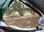
North Rim Campground at Black Canyon of the Gunnison National Park is located approximately 16 miles southwest of Crawford, CO. The last 7 miles of North Rim Road are unpaved. All sites are shaded within a Pinyon-Juniper forest. North Rim Campground has 13 sites and often fills during spring and fall, and occasionally fills during summer months. All sites are availab... -
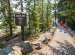
Hike North Rim Trail, Yellowstone National Park, Wyoming
Portions of this trail are paved and wheelchair accessible, especially near the major overlooks. The full-length walk is almost 3 miles (4.8 km). You can begin at either end; this description begins at the Wapiti Lake Trailhead on South Rim Drive near Chittenden Bridge. The first 0.5 miles (0.8 km) takes you close to the river and the brink of the Upper Fall... -
Hike or Cycle North Saskatchewan River Valley, Edmonton, Alberta
The North Saskatchewan River valley parks system is a continuous collection of urban parks in the North Saskatchewan River valley of Edmonton, Alberta. Edmonton's river valley comprises over 20 major parks and attractions and forms the largest expanses of urban parkland in North America. Referred to as a "Ribbon of Green", the public river valley parks provide a ... -
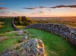
Explore Northumberland National Park, England
Northumberland National Park is the northernmost national park in England. It covers an area of more than 1,050 square kilometres (410 sq mi) between the Scottish border in the north to just south of Hadrian's Wall, and it is one of least visited of the National Parks. The park lies entirely within Northumberland, covering about a quarter of the county. The park cover... -
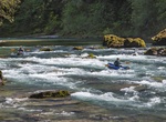
Raft or Kayak North Umpqua Wild and Scenic River, Oregon
This is a fun afternoon raft down the North Umpqua River with easy Class II and Class III rapids. You'll float by spires of volcanic rock on both sides, under several bridges and along a very twisty river with a lot of bends. There is even a fun place to stop and try out a rope swing into the river. The North Umpqua, a tributary of the Umpqua River that drains a sceni... -
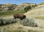
Explore North Unit, Theodore Roosevelt National Park, North Dakota
The North Unit is a bit off the beaten-path alongside ND Highway 85. Its ruggedness and beauty, and the solitude you'll find in this less-visited unit of the park are well worth the 50 mile drive from Interstate 94. -
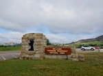
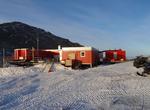
Visit North Unit Visitor Center, Theodore Roosevelt National Park, North Dakota
North Unit Visitor Center is located at the start of North Unit Scenic Drive. Trailers at the park entrance serve as a small, temporary visitor center for visitors to the North Unit. The original building had to be demolished due to structural failure. Planning for a new facility is underway. Park information, informal presentations, restrooms, and a gift shop are al... -
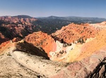
Visit North View Overlook, Cedar Breaks National Monument, Utah
The northern-most scenic overlook at the national monument, North View is located just inside the north entrance along Highway 143. The overlook features a large parking lot and interpretive waysides. The overlook is accessible by private vehicles.The area is open year-round, but access does vary throughout the year depending upon weather. Utah Department of Transport... -
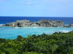
Explore Northwest Point National Park, Providenciales, Turks and Caicos
Northwest Point National Park on Providenciales Island is a great area to explore the rocky coastline, beach, birdwatch and snorkel (when the water is calm). -
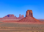
Visit North Window Overlook, Monument Valley, Arizona
North Window Overlook is an amazing stop within the Monument Valley Navajo Tribal Park. -
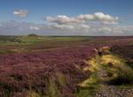
Explore North York Moors National Park, England
The North York Moors is a national park in North Yorkshire, England. The moors are one of the largest expanses of heather moorland in the United Kingdom. It covers an area of 1,436 km2 (554 sq mi), and it has a population of about 25,000. The North York Moors became a National Park in 1952, through the National Parks and Access to the Countryside Act of 1949. Many vis... -
Visit Norwegian Antarctica (Queen Maud Land), Antarctica
Queen Maud Land (Norwegian: Dronning Maud Land) is a c. 2.7 million-square-kilometre (1 million sq mi) region of Antarctica claimed as a dependent territory by Norway. The territory lies between 20° west and 45° east, between the British Antarctic Territory to the west and the Australian Antarctic Territory to the east. The latitudinal limits of the territory ... -
Explore Nouabalé-Ndoki National Park, Republic of the Congo (UNESCO site)
Nouabal-Ndoki National Park is a national park in the Republic of the Congo. Established in 1993, north of Congo, it is mostly populated with elephants, apes, ranging from Western Lowland Gorillas to chimpanzees and bongo. It is 3,921.61 km2 (1,514.14 sq mi) of pristine tropical rainforest with no human habitation within it and with least habitation in the peripheral ...