Give us feedback!

Our philosophy is simple. We want to encourage you to dream. BIG! Then we help you plan your trip, get the most out of it while you're traveling and help you share your experience with friends.
Join Now It's FREE
Related Categories
- Arizona State Parks
- Australian National Parks & Reserves
- Canada Provincial Parks
- Canadian National Parks
- New Zealand National Parks
- Parks & Reserves
- South African National Parks
- UK National Parks
- UNESCO Parks & Preserves
- US Historical Parks (NHP)
- US National Parks
- US Parks & Landmarks
- US State Parks
Dreams Still To Do
Checked-Off Dreams
Dreams Still To Do
Checked-Off Dreams
Advertisement
Explore Parks
-
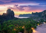
Climb Railay Viewpoint, Krabi, Thailand
Railay View point is a demanding hike, sometimes you even have to climb. There are slippery rocks that you have to walk on, ropes that you should hold on to and it might seem dangerous at first glance. Have full, comfortable shoes on and no fear. The view at the top is stunning and makes a perfect reward for the effort! -
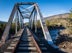
Camp at Railroad Bridge Campground, Buena Vista, Colorado
Railroad Bridge is located north of the town of Buena Vista. Traditionally, this site has been a popular river access point for boaters and gold-panners alike. It also is located fairly close to some of the better-known climbing in the region. View the Railroad Bridge Campground Map. Facilities: 14 basic campsites (each offers a tent pad, fire grill, and table) ... -
Visit Railtown 1897 State Historic Park, Jamestown, California
Railtown 1897 State Historic Park, and its operating entity, the Sierra Railway, is known as "The Movie Railroad." Both entities are a heritage railway and are a unit of the California State Park System. Railtown 1897 is located in Jamestown, California. The entire park preserves the historic core of the original Sierra Railway of California (later reincorporated as t... -
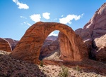
Explore Rainbow Bridge National Monument, Utah
Rainbow Bridge National Monument is administered by Glen Canyon National Recreation Area, southern Utah, USA. Rainbow Bridge is often described as the world's highest natural bridge. The span of Rainbow Bridge was reported in 1974 by the Bureau of Reclamation to be 275 feet , but a laser measurement in 2007 has resulted in a span of 234 feet . At the top it is 42 feet... -
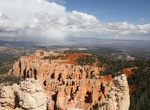
Visit Rainbow Point, Bryce Canyon National Park, Utah
From Rainbow Point, visitors can look northward and clearly see the Pink Cliffs out of which the Hoodoos have been sculpted. The cliffs curve around amphitheaters carved by the headward erosion of small streams and tributaries to the Paria River in times of flow. The entire Pink Cliffs of Bryce are but a single step in the much larger Grand Staircase. As first describ... -
Hike Rainbow Vista Trail, Valley of Fire State Park, Nevada
This viewpoint lives up to its name! Rainbow Vista is the perfect place for panoramic photos of the multi-colored sandstone in Valley of Fire State Park. Once your photo finger is exhausted, take the trail for a short hike through flaming red rocks. You will find some picnic tables and a restroom at the trailhead. The rocks are multi-colored, people! Don’t miss ... -
Hike Rainie Falls Trail, Oregon
Rainie Falls Trail is a 3.6 mile out and back trail located near Grants Pass, Oregon that features a waterfall. During spawning season, salmon and steelhead can be seen jumping at the falls. -
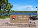
Visit Rainy Lake Visitor Center, Voyageurs National Park, Minnesota
Located on the shore of Black Bay with views across the water to the Kabetogama Peninsula. The Rainy Lake Visitor Center is open year-round, although hours of operation vary with the season. This visitor center serves people in the northern part of the park and is located 11 miles East on Highway 11 from International Falls, MInnesota. The visitor center offers an ex... -
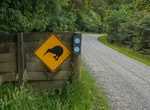
Explore Rakiura National Park, New Zealand
Rakiura National Park is a nature reserve park located on Stewart Island/Rakiura, New Zealand. It is the 14th of New Zealand's national parks and was officially opened on 9 March 2002. It covers 1,570 km², which is about 85% of Stewart Island, New Zealand's third-largest island. The park area excludes the township area around Halfmoon Bay (Oban) and some roads as... -
Visit Rakiura National Park Visitor Centre, Oban, New Zealand
For help with outdoor plans on Stewart Island/Rakiura, and to learn about the island's natural and cultural values, visit the Rakiura National Park Visitor Centre. The Rakiura National Park Visitor Centre is on Main Road, Oban - 2 minutes walk from the flight centre and ferry terminal. -
Visit Ramos National Park at Félicité Island, Seychelles
The Ramos National Park lies in the island of Félicité in the Seychelles archipelago of the western Indian Ocean. Ramos National Park covers two-thirds of Félicité island which is part of the Seychelles' Marine Protected Area (MPA). It is managed by Seychelles National Parks Authority since 1983, the Park's name is related to Ramos Mediterr... -
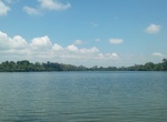
Explore Ramsagar National Park, Bangladesh
Ramsagar National Park is a national park in Bangladesh located at. 25°33'00"N 88°37'30"E Tejpur, near Dinajpur District in the north-west of the country. The Park is 27.76 hectare, in size, and is built around a large water reservoir known as "Ramsagar tank".The lake is 1079m in length and 192.6m in width. The soil is red-yellow clay. There are no big trees; ... -
Camp at Ranch Campground, Spring Valley State Park, Nevada
Ranch Campground is located two miles north of the main campground. This facility has seven campsites with tables and grills. Water and primitive restrooms are available. The camping limit is seven days in a 30-day period. -
Visit Rancho La Merced National Wildlife Refuge, Uvita, Costa Rica
Rancho La Merced offers amazing sunset horse riding tours along the beach. The guise will take care of you and you will definitely enjoy your time here! -
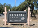
Visit Rancho Petaluma Adobe, Sonoma County, California
Rancho Petaluma Adobe is a historic ranch house in Sonoma County, California. It was built from adobe bricks in 1836 by order of Mariano Guadalupe Vallejo. It was the largest privately owned adobe structure built in California and is the largest example of the Monterey Colonial style of architecture in the United States. A section of the former ranch has been preserve...