Give us feedback!

Our philosophy is simple. We want to encourage you to dream. BIG! Then we help you plan your trip, get the most out of it while you're traveling and help you share your experience with friends.
Join Now It's FREE
Related Categories
- Arizona State Parks
- Australian National Parks & Reserves
- Canada Provincial Parks
- Canadian National Parks
- New Zealand National Parks
- Parks & Reserves
- South African National Parks
- UK National Parks
- UNESCO Parks & Preserves
- US Historical Parks (NHP)
- US National Parks
- US Parks & Landmarks
- US State Parks
Dreams Still To Do
Checked-Off Dreams
Dreams Still To Do
Checked-Off Dreams
Advertisement
Explore Parks
-
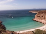
Explore San Lorenzo Marine Archipelago National Park, Baja California, Mexico
San Lorenzo Marine Archipelago National Park is a national park of Mexico located on San Lorenzo Island part of an archipelago in the Gulf of California off the eastern coast of Baja California. The San Lorenzo Archipelago is considered one of the most important ecological areas of the Gulf of California. The Island and surrounding areas are part of a rich ecosystem c... -
Explore San Luis National Wildlife Refuge, California
The San Luis National Wildlife Refuge in the San Joaquin Valley of central California is one of the great remnants of a historically bountiful wintering grounds for migratory waterfowl on the Pacific Flyway. Located in the Bear Creek, Salt Slough, and San Joaquin River floodplain, it hosts a myriad of tree-lined channels and oxbows, wetlands and native grasslands. Tho... -
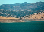
Explore San Luis Reservoir State Recreation Area, California
The San Luis Reservoir is an artificial lake on San Luis Creek in the eastern slopes of the Diablo Range of Merced County, California, approximately 12 mi (19 km) west of Los Banos on State Route 152, which crosses Pacheco Pass and runs along its north shore. It is the fifth largest reservoir in California. The reservoir stores water taken from the San Joaqu... -
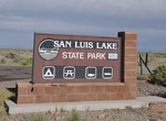
Visit San Luis State Park, Colorado
San Luis State Park is a former state park located in Alamosa County, Colorado, United States. In 2017, the property lost its status as a state park, and management of it was transferred to the San Luis Lakes State Wildlife Area. San Luis Lakes State Wildlife Area is located east of the town of Mosca, south off State Highway 150 near the Great Sand Dunes National Park... -
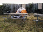
Camp at San Miguel Campground, San Miguel Island, California
Primitive camping is only available at the established campground near the historic Lester ranch site (nine sites; $15 per night per site; reservations required). Picnic table, food storage box, windbreak, and pit toilet are provided. Water is not available and there is no shade. Distance from the boat landing at Cuyler Harbor beach to the campground is a steep, uphi... -
Visit San Miguel Ranger Station, San Miguel Island, California
National Park Service personnel are stationed here year-round to lead nature hikes and provide visitor and resources protection. -
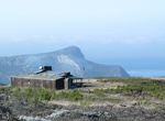
Visit Sanminedidisiv Paya, Mindat, Myanmar
Only15minutesfrom the marketyouwillfinda small stupa withviewsaboveMindat.Climbingsteepstepsisnecessarytogettherebutthinkaboutthebeautifulmountainsaround! -
Visit San Onofre State Beach, San Clemente, California
San Onofre State Beach is a 3,000-acre (1,214 ha) state park located in San Diego County, California, USA. The beach is 3 miles (5 km) south of the city of San Clemente on Interstate 5 at Basilone Road. The state park is leased to the state of California by the United States Marine Corps. Governor Ronald Reagan established San Onofre State Beach in 1971. With over 2.5... -
Birding at San Pablo Bay National Wildlife Refuge, California
San Pablo Bay National Wildlife Refuge is a 13,190-acre (53.4 km2) National Wildlife Refuge in California established in 1970. It extends along the northern shore of San Pablo Bay from the mouth of the Petaluma River to Tolay Creek, Sonoma Creek and ends at Mare Island. The refuge encompasses the largest remaining continuous patch of pickleweed-dominated tidal marsh i... -
Explore San Pasqual Battlefield State Historic Park, Escondido, California
San Pasqual Battlefield State Historic Park honors the soldiers who fought in the 1846 Battle of San Pasqual, the bloodiest battle in California during the Mexican-American War. The battle was fought between United States troops under the command of General Stephen Kearny, and the California forces under the command of General Andres Pico on December 6, 1846. The Nati... -
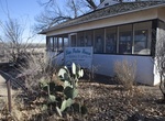
Visit San Pedro House Visitor Center, Sierra Vista, Arizona
The San Pedro House is located 9 miles east of Sierra Vista on Arizona Route 90, is a popular trailhead for birdwatchers, hikers, and mountain bikers. The Friends of San Pedro operate a bookstore and information center. -
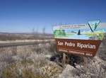
Explore San Pedro Riparian National Conservation Area, Arizona
The San Pedro Riparian National Conservation Area (San Pedro Riparian NCA) contains nearly 57,000 acres (23,000 ha) of public land in Cochise County, Arizona, between the international border with Mexico and St. David, Arizona. The riparian area, where some 40 miles (64 km) of the upper San Pedro River meanders, was designated by Congress as a Riparian National Conser... -
Camp around San Quintín, Baja California
San Quintín is a coastal town on the west coast of the Mexican state of Baja California, some 190 km south of the city of Ensenada on Mexican Federal Highway 1. San Quintín has beautiful beaches and several places for tourists to stay. Tourists can enjoy fishing, camping, bird watching, surfing, and clam digging. -
Camp at San Rafael Bridge Campground, San Rafael Swell, Utah
Camping facilities are provided at the San Rafael Bridge Recreation Site, adjacent to the San Rafael River. This recreation site is bordered by the lofty escarpment to the north and large buttes to the east and west. The North Campground consists of 1 large group site and 8 individual campsites containing tent pads, picnic tables, toilets, parking areas and fire rings... -
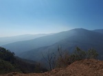
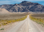
Explore San Rafael Swell, Utah
The San Rafael Swell is a large geologic feature located in south-central Utah, United States about 16 miles (26 km) west of Green River. The San Rafael Swell, measuring approximately 75 by 40 miles (121 by 64 km), consists of a giant dome-shaped anticline of sandstone, shale, and limestone that was pushed up during the Paleocene Laramide Orogeny 60–40 million y...