Give us feedback!

Our philosophy is simple. We want to encourage you to dream. BIG! Then we help you plan your trip, get the most out of it while you're traveling and help you share your experience with friends.
Join Now It's FREE
Related Categories
- Arizona State Parks
- Australian National Parks & Reserves
- Canada Provincial Parks
- Canadian National Parks
- New Zealand National Parks
- Parks & Reserves
- South African National Parks
- UK National Parks
- UNESCO Parks & Preserves
- US Historical Parks (NHP)
- US National Parks
- US Parks & Landmarks
- US State Parks
Dreams Still To Do
Checked-Off Dreams
Dreams Still To Do
Checked-Off Dreams
Advertisement
Explore Parks
-
Off-road St. Anthony Sand Dunes, Idaho
Located far from any ocean, the BLM-managed St. Anthony Sand Dunes appears as a rolling sea of sand on the eastern edge of Idaho’s volcanic Snake River Plain. These vast dunes are the largest in Idaho. They blanket an area approximately 35 miles long and 5 wide, and range from 50 to 500 feet high. These white quartz sand dunes are a unique and popular recrea... -
Camp Stanton Creek Campground, Lake Powell, Utah
Designated primitive camping areas that are accessible by vehicle and sometimes by vessel as well. First-come first served, no reservations. No designated sites. No potable water. When pit toilets are unavailable, campers must bring portable toilets for use and proper disposal into the sewer system. -
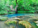
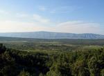
Explore Stara Planina National Park, Serbia
Rugged landscape of gorges & waterfalls, popular for swimming, hiking trails & peak views. -
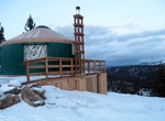
Camp at Stargaze Yurt, Boise National Forest, Idaho
To get to the Stargaze Yurt follow the Stargaze Trail roughly 1.2 miles from the Beaver Creek Summit Park N’ Ski on ID 21. Scan for a yellow blaze and then head the final .2 mile through the pines to the yurt. Idaho State Park yurts are circular, Mongolian-style domed tents. Every park yurt is about 20 feet in diameter with a plywood floor, canvas and hardwood ... -
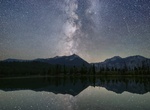
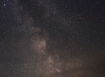
Go Stargazing at Central Idaho Dark Sky Reserve, Idaho
The Central Idaho Dark Sky Reserve is a 1,416-square-mile (3,670 km2) dark-sky preserve near the Sawtooth National Recreation Area, in the U.S. state of Idaho. It was designated on December 18, 2017 and is the first gold-tier dark sky preserve in the United States. The area was designated by International Dark-Sky Association. The area includes the city of Ketchum, Id... -
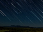
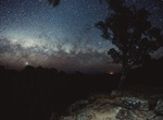
Go Stargazing in Katahdin Woods and Waters National Monument, Maine
Starry nights at Katahdin Woods and Waters National Monument are exceptional, with night sky readings that prove the monument and its surrounding neighbors have some of the darkest skies east of the Mississippi. Within its 87,564 acres there are no electric lights and no commercial power sources. Katahdin Woods and Waters National Monument is an International Dark Sk... -
Go Stargazing in The Headlands International Dark Sky Park, Michigan
The Headlands International Dark Sky Park is a 550-acre (220 ha) county park in the U.S. state of Michigan. The park preserves over two miles (3 km) of undeveloped Lake Michigan shoreline south and west of McGulpin Point Light in the Straits of Mackinac. It is located in, and is operated by, Emmet County in Northern Michigan. The nearest town is Mackinaw City, Michiga... -
Go Stargazing in Warrumbungle National Park, New South Wales, Australia
On 4 July 2016, the Warrumbungle National Park was the first within Australia to be certified as a Dark Sky Park by the International Dark Sky Association. -
Explore Stari Grad Plain, Hvar Island, Croatia (UNESCO site)
The Stari Grad Plain on the island of Hvar is an agricultural landscape that was set up by the ancient Greek colonists in the 4th century BC, and remains in use today. The plain is generally still in its original form. The ancient layout has been preserved by careful maintenance of the stone walls over 24 centuries, along with the stone shelters (known locally as trim... -
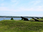
Visit Star of India Ship, San Diego Embarcadero
Star of India was built in 1863 at Ramsey in the Isle of Man as Euterpe, a full-rigged iron windjammer ship. After a full career sailing from Great Britain to India and New Zealand, she became a salmon hauler on the Alaska to California route. Retired in 1926, she was not restored until 1962–63 and is now a seaworthy museum ship home-ported at the Maritime Museu... -
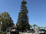
See Star Pine Tree (Heritage Tree #3) & Rotary Park, Coronado, California
Located in Rotary Plaza was designated a Heritage Tree on April 3, 2008. This Araucaria Heterophylla is native to Norfolk Island in the SW Pacific and was transplanted to this location by Supt. Bandel in 1936. The project was funded by the Coronado Rotarians and has since served as the City's living Christmas tree. Star pines can grow to 100 feet in height. Loc... -
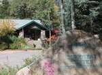
Visit Starsmore Visitor and Nature Center, Colorado Springs, Colorado
The Starsmore Visitor and Nature Center is located on South Cheyenne Canyon Road at the entrance to North Cheyenne Cañon Park. It is the visitor center for the North Cheyenne Cañon Park that has hands-on exhibits, nature programs, and information about the park. The lower columbine trails starts near Starsmore and continues on for about four miles to Hel... -
Hike Star-Spangled Banner National Historic Trail, USA
The Star-Spangled Banner National Historic Trail is a National Historic Trail that commemorates the Chesapeake Campaign of the War of 1812. The 290-mile (467 km) trail was named after "The Star-Spangled Banner," the national anthem of the United States. Consisting of water and overland routes, the trail extends from Tangier Island, Virginia, through southern Maryland,... -
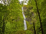
Explore Starvation Creek State Park, Oregon
Starvation Creek State Park is located west of Hood River, Oregon in the Columbia River Gorge. Starvation Creek has a small waterfall and a trailhead for hiking. It was named Starvation Creek because a train was stopped there by snow drifts and passengers had to dig the train out. No one actually starved there. Starvation Creek State Park in Oregon has four sets of in... -
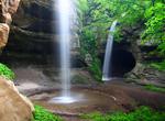
Explore Starved Rock State Park, Illinois
Starved Rock State Park is a state park in Illinois, characterized by the many canyons within its 2,630 acres (1,064 ha). Located just southwest of the village of North Utica, in Deer Park Township, LaSalle County, Illinois, along the south bank of the Illinois River, the park hosts over two million visitors annually. There are over 13 miles (21 km) of hiking trails i...