Give us feedback!

Our philosophy is simple. We want to encourage you to dream. BIG! Then we help you plan your trip, get the most out of it while you're traveling and help you share your experience with friends.
Join Now It's FREE
Related Categories
- Arizona State Parks
- Australian National Parks & Reserves
- Canada Provincial Parks
- Canadian National Parks
- New Zealand National Parks
- Parks & Reserves
- South African National Parks
- UK National Parks
- UNESCO Parks & Preserves
- US Historical Parks (NHP)
- US National Parks
- US Parks & Landmarks
- US State Parks
Dreams Still To Do
Checked-Off Dreams
Dreams Still To Do
Checked-Off Dreams
Advertisement
Explore Parks
-
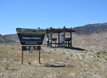
Visit Canyon Station, Pony Express Trail, Utah
This Pony Express station is the third one in this area due to the other two stations being burned by the indians. The original station is located up the canyon about three miles to the west. -
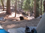
Camp at Canyon View Campground, Kings Canyon National Park, California
Canyon View Campground is for medium and large groups only. It is on Highway 180, 1/4 mile (.4 km) from Cedar Grove Village. The campground is in the canyon near the South Fork of the Kings River at 4,600 ft (1,402 m) elevation. This campground has 12 sites for mid-size groups (7-15 people) and four sites for large groups (15-30 people). The sites are for tent and ca... -
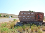
Visit Canyon Visitor Center, Dinosaur National Monument, Colorado
Located near Dinosaur, Colorado, at the base of the Harpers Corner Road, the Canyon Visitor Center serves as a gateway to the monument's mountains and river canyons. Exhibits orient visitors to the monument's facilities. An Intermountain Natural History Association bookstore sells items that will further enhance your experience. Staff are available to answer questions... -
Visit Canyon Visitor Education Center, Yellowstone National Park, Wyoming
Explore Yellowstone's supervolcano and geology. Information and vending is available during open hours, restrooms are available 24 hours a day. Learn more about the Canyon area National Park Service visitor facilities. -
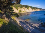
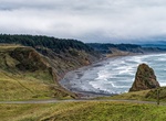
Explore Cape Arago State Park, Coos Bay, Oregon
Cape Arago State Park is a state park in the U.S. state of Oregon, administered by the Oregon Parks and Recreation Department. Cape Arago is north of Bandon and 15 miles southwest of Coos Bay on Cape Arago Highway in Coos County. In 1579, Sir Francis Drake is purported to have sought shelter for his ship, theGolden Hinde, around Cape Arago. The headland was originally... -
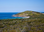
Explore Cape Arid National Park, Western Australia
Cape Arid National Park is a national park in Western Australia (Australia), 731 kilometres (454 mi) south-east of Perth. The park is situated 120 kilometres (75 mi) east of Esperance and lies on shore from the eastern end of the Recherche Archipelago. The bay at its western end isDuke of Orleans Bay, and the bay at the eastern side is Israelite Bay. Its coastline is ... -
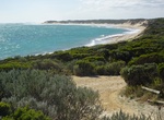
Camp at Cape Banks Lighthouse Campground, Canunda National Park, South Australia
Located approximately 5km NW from Carpenter Rocks. Accessible by 2WD and with a small caravan. Situated near the historical Cape Banks Lighthouse, there are 6 campsites which are reasonably sheltered from wind with minimal shade. Ocean beach is 100 metres from camping area and is safe for swimming when the swell is small. Good fishing beach.Access 2WD and 4WD.Suitable... -
Visit Cape Blanco State Park, Oregon
Cape Blanco is a prominent headland on the Pacific Ocean coast of southwestern Oregon in the United States, forming the westernmost point in the state. It contests with Cape Alava in Washington for the title of westernmost point in the contiguous United States. This contention is due to land shifts and measurement anomalies as well as whether to measure at high or low... -
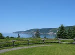
Explore Cape Breton Highlands National Park, Nova Scotia, Canada
Cape Breton Highlands National Park is located on northern Cape Breton Island in the province of Nova Scotia. One-third of the Cabot Trail passes through the park featuring spectacular ocean and mountain views. The park was the first National Park in the Atlantic provinces of Canada and covers an area of 948 km². It is one of 42 in Canada's system of national par... -
Explore Cape Chignecto Provincial Park, Nova Scotia, Canada
Cape Chignecto Provincial Park is a Canadian provincial park located in Nova Scotia. A wilderness park, it derives its name from Cape Chignecto, a prominent headland which divides the Bay of Fundy with Chignecto Bay to the north and the Minas Channel leading to the Minas Basin to the east. The park, which opened in 1998, is the largest provincial park in Nova Scotia. ... -
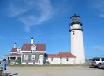
See Cape Cod Highland Light, Massachusetts
The Cape Cod Highland Lighthouse is a working lighthouse on the Cape Cod National Seashore in North Truro, Massachusetts. It is the oldest and tallest lighthouse on Cape Cod. The grounds are open year round, while the light is open to the public from May until late October, with guided tours available. It is owned by the National Park Service, and cared for by the Hig... -
Explore Cape Cod National Seashore, Massachusetts
The Cape Cod National Seashore (CCNS) encompasses 43,500 acres (176 km2) on Cape Cod, Massachusetts. It includes ponds, woods and beachfront of the Atlantic coastal pine barrens ecoregion. The CCNS includes nearly 40 miles (64 km) of seashore along the Atlantic-facing eastern edge of Cape Cod, in the towns of Provincetown, Truro, Wellfleet, Eastham, Orleans and Chatha... -
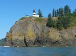
Visit Cape Disappointment State Park, Washington
Cape Disappointment is a headland located at the extreme southwestern corner of Washington State on the north side of the Columbia River bar. The point of the cape is located on the Pacific Ocean in Pacific County, approximately two miles (3.2 km) southwest of the town of Ilwaco. Cape Disappointment receives about 2552 hours of fog a year – the equivalent of 106... -
Visit Cape Ferrelo Viewpoint, Samuel H. Boardman State Scenic Corridor, Oregon
Viewpoint along Hwy 101. A mile-long hike leads to breathtaking views of the rugged coastline and photo-worthy Oregon sunsets. The Cape is also an excellent spot for whale watching in fall and spring. -
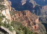
Hike Cape Final Trail, Grand Canyon National Park, Arizona
Cape Final Trail is a 4.0 mile (6.4 km) round-trip hiking trail along the North Rim of Grand Canyon National Park. It takes approximately 2 hours round-trip hiking time and has an elevation gain of 210 ft (64 m). Cape Final is at an elevation of 7,916 feet (2,413 m) and overlooks the eastern Grand Canyon from Nankoweap to the Unkar Creek Delta. It also shows how ...