Give us feedback!

Our philosophy is simple. We want to encourage you to dream. BIG! Then we help you plan your trip, get the most out of it while you're traveling and help you share your experience with friends.
Join Now It's FREE
Related Categories
- Arizona State Parks
- Australian National Parks & Reserves
- Canada Provincial Parks
- Canadian National Parks
- New Zealand National Parks
- Parks & Reserves
- South African National Parks
- UK National Parks
- UNESCO Parks & Preserves
- US Historical Parks (NHP)
- US National Parks
- US Parks & Landmarks
- US State Parks
Dreams Still To Do
Checked-Off Dreams
Dreams Still To Do
Checked-Off Dreams
Advertisement
Explore Parks
-
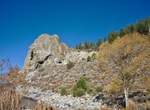
Hike to top of Cave Rock, Lake Tahoe, Nevada
Cave Rock is located on the eastern side of Lake Tahoe. To climb up on the rock go to Cave Rock Drive across the road from the beach parking. -
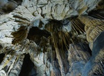
Explore Caves of Aggtelek Karst and Slovak Karst, Hungary & Slovakia (UNESCO sites)
The Caves of Aggtelek Karst and Slovak Karst are a series of over 1000 karst caves spread out over a total area of 55,800 ha (138,000 acres) along the border of Hungary and Slovakia. With an exceptional diversity of karst structures and complex cave systems developing from both temperate and tropical processes, the caves and surrounding areas were inscribed as a UNESC... -
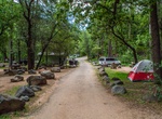
Camp at Cave Springs Campground in Oak Creek Canyon, Coconino National Forest, Arizona
Oak Creek Canyon is a river gorge located along the Mogollon Rim in northern Arizona between the cities of Flagstaff and Sedona. The canyon is often described as a smaller cousin of the Grand Canyon because of its scenic beauty. State Route 89A enters the canyon on its north end via a series of hairpin turns before traversing the bottom of the canyon for about 13 mile... -
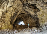
Hike Caves Trail (Dewdrop Cave, Indian Tunnel, Beauty Cave & Boy Scout Cave), Craters of the Moon National Monument, Idaho
The Caves Trail (1.6 mi/2.6 km) covers the Cave Area is the final stop on Loop Drive and, as the name indicates, has a collection of lava tube caves. On a summer day, the cool, dark lava tubes along the Caves Trail offer a radical change from the brilliant light and blistering heat on the surface. Formed from the Blue Dragon Flow, the caves are a half-mile (800 m) fro... -
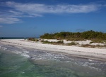
Explore Cayo Costa State Park, Lee County, Florida
Cayo Costa State Park is a Florida State Park on Cayo Costa (formerly known as La Costa Island (Padilla Rancho)), which is directly south of Boca Grande (Gasparilla Island), 12 miles (19 km) west of Cape Coral and just north of North Captiva Island. The park is accessible only by charter boat (with or without captain), private boat, ferry or helicopter. Cayo Costa was... -
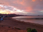
Visit Cayucos State Beach, California
Cayucos State Beach is a protected beach in the state park system of California, United States. It is located in Cayucos, San Luis Obispo County. The sandy beach environment supports uses of swimming and surfing. Prehistorically this general area of the central coast was inhabited by the Chumash people, who settled the coastal San Luis Obispo area approximately 10,000... -
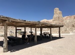
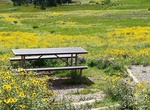
Visit CCC Day Use Picnic Area at Cathedral Gorge, Nevada
CCC Day Use Picnic Area at Cathedral Gorge -
Visit Ceann Sléibhe, Dingle Peninsula, Ireland
Ceann Sléibhe is a nice viewpoint along Slea Head Drive. -
Explore Cebolla Wilderness, New Mexico
BLM's Cebolla Wilderness, located within the El Malpais National Conservation Area, includes 61,600 acres of rimrock country east of NM 117. Sanstone mesas, canyons and grassy valleys characterize the area. The Mesas and canyons are clad with juniper, piñon, and ponderosa pine. Vertical escarpments provide excellent nesting habitat for golden eagles, prairie fa... -
Explore Cecil D. Andrus–White Clouds Wilderness, Idaho
The Cecil D. Andrus–White Clouds Wilderness is a 90,769-acre (367.33 km2) protected area in the western United States, located in Custer County, Idaho. The Sawtooth National Recreation Area, in the Sawtooth National Forest, manages the majority of the wilderness, with 450 acres (180 ha) managed by the Bureau of Land Management at the wilderness's eastern edge al... -
Explore Cedar Bay National Park, Queensland, Australia (UNESCO Site)
Cedar Bay is a 56.5 km2 (21.8 sq mi) national park in Queensland, Australia, 1,522 km (946 mi) northwest of Brisbane, 40 km (25 mi) south of Cooktown and accessible only by boat or foot. The park is one of the Wet Tropics World Heritage Area series of national parks, and is a gazetted World Heritage site. It is also known as Mangkal-Mangkalba in the dialect of the loc... -
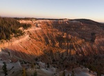
Explore Cedar Breaks National Monument, Utah
Cedar Breaks National Monument is a U.S. National Monument located in the U.S. state of Utah near Cedar City. Located at 10,350 feet elevation, Cedar Breaks National Monument makes a nice reprieve from the summers heat found at Zion National Park and the Grand Canyon. Cedar Breaks is a natural amphitheater canyon, stretching across 3 miles (4.8 km), with a depth of ov... -
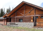
Visit Cedar Breaks National Monument Visitor Center
The new Cedar Breaks Visitor Contact Station opened in August 2024. The new building will be home to: Ranger-led programs and activities Dark sky resources Wildflower events Interpretive exhibits The park store The Visitor Contact Station will be a permanent feature to welcome visitors to Cedar Breaks with an expanded open season. Cedar Breaks’ former Infor... -
Visit Cedar Breaks Picnic Area, Cedar Breaks National Monument, Utah
The park picnic area is located at the half-way point of the Sunset Trail. Also accesable via car on the road to Point Supreme campground. -
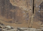
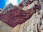
Off-road to Cedar Canyon Petroglyphs, Wyoming
The Cedar Canyon Petroglyphs are dated back more than 200 years, with some of the petroglyphs unique to this location, including several panels that include depictions of plants and markings referred to as calendars. Cedar Canyon is south of Fifteenmile Knoll and southwest of Pine Canyon. Cedar Canyon has an elevation of 6,542 feet. The panels are a 250 ft uphill wal...