Give us feedback!

Our philosophy is simple. We want to encourage you to dream. BIG! Then we help you plan your trip, get the most out of it while you're traveling and help you share your experience with friends.
Join Now It's FREE
Related Categories
- Arizona State Parks
- Australian National Parks & Reserves
- Canada Provincial Parks
- Canadian National Parks
- New Zealand National Parks
- Parks & Reserves
- South African National Parks
- UK National Parks
- UNESCO Parks & Preserves
- US Historical Parks (NHP)
- US National Parks
- US Parks & Landmarks
- US State Parks
Dreams Still To Do
Checked-Off Dreams
Dreams Still To Do
Checked-Off Dreams
Advertisement
Explore Parks
-
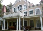
Visit Clara Barton National Historic Site, Glen Echo, Maryland
The Clara Barton National Historic Site, which includes the Clara Barton House, was established in 1974 to interpret the life of Clara Barton (1821–1912), an American pioneer teacher, nurse, and humanitarian who was the founder of the American Red Cross. The site is located 2 miles (3.2 km) northwest of Washington D.C. in Glen Echo, Maryland. The United States N... -
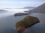
Explore Clayoquot Sound, Vancouver Island, British Columbia, Canada
Clayoquot Sound is located on the west coast of Vancouver Island in the Canadian province of British Columbia. It is bordered by the Esowista Peninsula to the south, and the Hesquiaht Peninsula to the North. It is a body of water with many inlets and islands. Major inlets include Sydney Inlet, Shelter Inlet, Herbert Inlet, Bedwell Inlet, Lemmens Inlet, and Tofino Inle... -
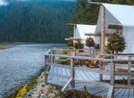
Stay at Clayoquot Wilderness Resort, Tofino, British Columbia
Set along the Bedwell River, this upscale, tented resort is open seasonally, and reached only by seaplane or a 30-minute boat ride from Tofino. Safari-style tents with electricity and a Victorian vibe feature opulent rugs, antique furnishings and plush wooden beds, and have adjacent private composting toilets. Upgraded luxury tents add en suite bathrooms with indoor/o... -
Visit Clayton Lake State Park, New Mexico
Clayton Lake State Park is a state park of New Mexico, United States, featuring a 170-acre (69 ha) recreational reservoir and a fossil trackway of dinosaur footprints. It is located 15 miles (24 km) north of Clayton, close to New Mexico's border with Colorado, Oklahoma, and Texas. The park is accessed via New Mexico State Road 455. The landscape is characterized by ro... -
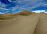
Explore Clayton Valley Dunes, Nevada
Clayton Valley Sand Dunes was designated as a SRMA in the Tonopah RMP and ROD. The site is closed to competitive recreational events. OHV use is limited to existing roads and trails. OHV use on un-vegetated sand areas is allowed. Travel SR 265 to Silver Peak continue on the road past the industrial plant, continue down the Oasis Divide Road for approximately 6.3 miles... -
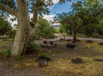
Camp at Clear Creek Campground, Sedona, Arizona
West Clear Creek flows along the boundary of this desert canyon country camp and is a popular place for hiking, swimming, wading and fishing. Cool water species such as smallmouth bass and green sunfish populate the stream near the campground. The oasis bordering the creek and extending into the campground is an excellent place for wildlife watching. It provides a pro... -
Explore Clear Creek Management Area (CCMA), California
Clear Creek Management Area (CCMA) encompasses approximately 75,000 acres, of which 63,000 acres are public lands managed by the Bureau of Land Management Central Coast Field Office. Topography is rugged with elevations ranging from 1,830 feet at Pine Canyon to 5,241 feet on San Benito Mountain. The Mediterranean climate is punctuated by cool, wet winters and hot, dry... -
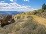
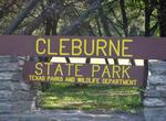
Explore Cleburne State Park, Texas
Cleburne State Park is a 500-acre (2.0 km2) Texas state park in Johnson County, Texas operated by the Texas Parks and Wildlife Department. Fishing is an extremely popular activity on the lake. Boating is allowed although the speed limit on the lake is restricted to 5 mph (8.0 km/h) which prohibits speed and personal water craft and creates a quiet peaceful atmosphere.... -
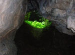
Visit Cleeves Cove, North Ayrshire, Scotland
Cleeves Cove or Blair Cove is a cave system on the Dusk Water in North Ayrshire, Scotland, close to the town of Dalry. The Cleeves, or Cleaves Cove (Scots) cave system is situated in the lower bed of carboniferous limestone. It measures around 500 feet if all the passages were put together. The caves are now well above the level of the Dusk Water and lie close to Clee... -
Visit Cleland National Park, South Australia
Cleland Wildlife Park is home to some of South Australia's most iconic inhabitants, and is less than twenty minutes from the Adelaide city centre. The Wildlife Park is accessible by sealed road from both the South Eastern Freeway and Greenhill Road, and on foot on a formed but steep track from Waterfall Gully or Mount Lofty. A limited public bus service operates. A f... -
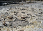
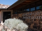
Visit Cleveland Lloyd Dinosaur Quarry (Jurassic National Monument), Utah
Jurassic National Monument, at the site of the Cleveland-Lloyd Dinosaur Quarry, well known for containing the densest concentration of Jurassic dinosaur fossils ever found, is a paleontological site located near Cleveland, Utah, in the San Rafael Swell, a part of the geological layers known as the Morrison Formation. Well over 15,000 bones have been excavated from thi... -
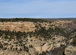
Visit Cliff Canyon Overlook, Mesa Verde National Park, Colorado
Cliff Canyon Overlook and Cliff Palace Loop Road are open 8 am to sunset from late spring to December 1, or until the first significant snowfall.The Cliff Canyon Overlook opens up to a stunning view of Cliff Canyon. In the 1200s, Cliff Canyon was a thriving neighborhood, where Ancestral Pueblo people went about their daily lives.With careful observation, vis... -
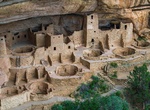
Visit Cliff Palace Overlook, Mesa Verde National Park, Colorado
With at least 150 rooms and 21 kivas, Cliff Palace is an exceptionally large cliff dwelling. It was surrounded by a vibrant, active community. Because of the large kiva to room ratio, some scholars suggest Cliff Palace was an important gathering place, perhaps an administrative center with ceremonial use for many Ancestral Pueblo villages. The people who lived in the ... -
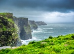
Explore Cliffs of Moher, Ireland
The Cliffs of Moher (cliffs of the ruin) are located in the parish of Liscannor at the south-western edge of the Burren area near Doolin, which is located in County Clare, Ireland. The cliffs rise 120 meters (394 ft) above the Atlantic Ocean at Hag's Head (Irish: Ceann na Cailleach), and reach their maximum height of 214 meters (702 ft) just north of O'Brien's Tower, ... -
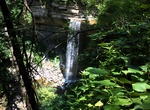
Explore Clifty Falls State Park, Indiana
Clifty Falls State Park is an Indiana state park on 1,416 acres (573 ha) in Jefferson County, Indiana in the United States. It is 46 miles (74 km) northeast of Louisville, Kentucky. On Oct. 27, 1920, citizens of Madison, Indiana gave the land for the park, 570 acres (230 ha), to the state of Indiana at the suggestion of Richard Lieber. This was after a year's work by ...