Give us feedback!

Our philosophy is simple. We want to encourage you to dream. BIG! Then we help you plan your trip, get the most out of it while you're traveling and help you share your experience with friends.
Join Now It's FREE
Related Categories
- Arizona State Parks
- Australian National Parks & Reserves
- Canada Provincial Parks
- Canadian National Parks
- New Zealand National Parks
- Parks & Reserves
- South African National Parks
- UK National Parks
- UNESCO Parks & Preserves
- US Historical Parks (NHP)
- US National Parks
- US Parks & Landmarks
- US State Parks
Dreams Still To Do
Checked-Off Dreams
Dreams Still To Do
Checked-Off Dreams
Advertisement
Explore Parks
-
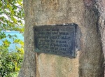
Visit Cooktown Captain Cook Memorial Park, Cooktown, Queensland, Australia
This stone marks the spot where James Cook beached the Endeavour in 1770 for repairs after hitting a reef. -
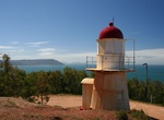
Visit Cooktown Lighthouse & Grassy Hill Lookout, Cooktown, Queensland, Australia
Cooktown Lighthouse is located on the top of Grassy Hill above Cooktown. Great views of the area. -
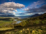
Explore Cooley Peninsula, Ireland
The Cooley Peninsula (Cuaille, older Cuailghe) is a hilly peninsula in County Louth, Ireland, which includes towns such as Omeath, Carlingford and Greenore. Enjoy the views from the forested Mourne Mountains, stop off at the charming medieval village of Carlingford and walk the windswept coastline in one of the country's most rewarding off-the-beaten-track destination... -
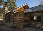
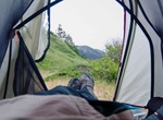
Camp at Coon Creek Cabin Group Campground, Sand to Snow National Monument, California
This group campground is located in a pine forest within the Sand to Snow National Monument. The camping area can accommodate a maximum of 25 persons and 10 vehicles. There are 3 historic cabins on the grounds (cabins have walls/roof, but no doors/windows. Amenities include picnic tables, trash cans, 1 group fire ring and 1 vault toilet. Firewood is available at Heart... -
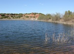
Camp at Coon Hollow Campground, Colorado Desert, California
Located in the lower Colorado Desert in eastern Riverside County, the Coon Hollow campground is located adjacent to a desert riparian wash populated by palo verde, smoke tree, mesquite and ironwood trees. There is easy 4-wheel drive access to nearby rock-hounding sites: Hauser Geode Beds and Opal Hill Fire Agate Mine. The historic Bradshaw Trail National Scenic Byway ... -
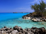
Explore Cooper's Island Nature Reserve, Bermuda
Cooper's Island is part of the chain which makes up Bermuda. It is located in St. George's Parish, in the northeast of the territory. The 77-acre (31 hectare) island is located in the northeast of Castle Harbor. Due to reclamation work, it is now joined physically to St. David's Island as a southeastern peninsula. For most purposes, it is still considered as though it... -
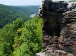
Explore Coopers Rock State Forest, West Virginia
Coopers Rock State Forest is a 12,747-acre (52 km2) state forest in Monongalia and Preston counties in the U.S. state of West Virginia. Its southern edge abuts Cheat Lake and the canyon section of Cheat River, a popular whitewater rafting river in the eastern US. Coopers Rock State Forest gets its name from a legend about a fugitive who hid from the law near what is n... -
Camp at Cooskie Campground (Cooskie Creek Trail), Honeydew, California
Cooskie Creek Trail (Punta Gorda to Spanish Ridge Trailhead) 12.8 miles, 2400 ft. climb, 2300 ft. descent, 2300 ft. climb This trail currently has a break where it crosses private property about 1-mile north of the Spanish Ridge Trailhead. The 11 miles south of the private land climbs up and down grassy ridges with clumps of windblown Douglas-fir, offering great views... -
Visit Copley Square, Boston, Massachusetts
Copley Square, named for painter John Singleton Copley, is a public square in Boston's Back Bay neighborhood, bounded by Boylston Street, Clarendon Street, St. James Avenue, and Dartmouth Street. The Boston Marathon has finished at Copley Square since 1986. A memorial celebrating the race's 100th running (in 1996) is located in the park, near the corner of Boylston an... -
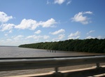
Explore Coppename Nature Preserve, Suriname
Coppename Nature Preserve is located near Paramaribo, Suriname. -
Explore Copper Breaks State Park, Texas
Copper Breaks State Park is a state park in Hardeman County, located approximately 12 miles (19 km) south of Quanah. It covers around 1,900 acres (770 ha) and contains two small lakes and 10 miles (16 km) of trails. Activities include camping, picnicking, boating, fishing, mountain biking, swimming, wildlife viewing, backpacking, kite flying, summer educational/inter... -
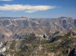
Explore Copper Canyon National Park, Mexico
Copper Canyon (Spanish: Barranca del Cobre) is a group of canyons consisting of six distinct canyons in the Sierra Tarahumara in the southwestern part of the state of Chihuahua in Mexico. The overall canyon system is larger and portions are deeper than the Grand Canyon in neighboring Arizona. The canyons were formed by six rivers which drain the western side of the Si... -
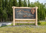
Visit Copper Center Visitor Center, Wrangell–St. Elias National Park, Alaska
Located 10 miles south from the intersection of the Glenn Highway and the Richardson Highway, the Copper Center Visitor Center Complex is the place to start your visit to the park.The campus-like setting includes: a visitor center, a bookstore, an exhibit hall, a theater, restrooms, picnic tables and a picnic shelter, an amphitheater, the Ahtna Cultural Center, scenic... -
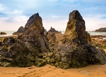
Explore Copper Coast Geopark, Ireland
The Copper Coast Geopark is a designated area comprising a stretch of the southern coast of Ireland in County Waterford, extending for some 17 km from Kilfarrasy in the east to Stradbally in the west. It was the first geopark designated in the state, and the second on the island. The coast, and the geopark, are named for the historic metal-mining industry, the legacie... -
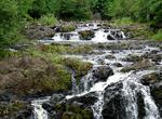
Explore Copper Falls State Park, Wisconsin
Copper Falls State Park is a 3,068-acre (1,242 ha) Wisconsin state park in which the Bad River and its tributary the Tylers Forks flow through a gorge and drop over several waterfalls. Old Copper Culture Indians and later European settlers mined copper in the area. The North Country National Scenic Trail runs through the park. Copper Falls is about two miles northe...