Give us feedback!


 See all

Our philosophy is simple. We want to encourage you to dream. BIG! Then we help you plan your trip, get the most out of it while you're traveling and help you share your experience with friends.
Join Now It's FREE
Dream Packages
Duration: 8 hours
Price: $83.37
Price: $83.37
Duration: 3 hours 30 minutes
Price: $99.36
Price: $99.36
Duration: 7 hours
Price: $144.00
Price: $144.00
Duration: 3 hours
Price: $173.83
Price: $173.83
Dreams Still To Do
Checked-Off Dreams
Dreams Still To Do
Checked-Off Dreams
Advertisement
Explore Adventure Sports
-
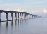
Drive across Confederation Bridge, Canada
The Confederation Bridge is a bridge spanning the Abegweit Passage of Northumberland Strait, linking Prince Edward Island with mainland New Brunswick, Canada. It was commonly referred to as the "Fixed Link" (cf. fixed link) by residents of Prince Edward Island prior to its official naming. The 12.9-kilometre (8 mi) long bridge opened on 31 May 1997. The bridge is a tw... -
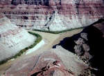
Hike Confluence Overlook Trail, Canyonlands National Park, Utah
The Confluence Overlook Trail is a 10 miles (16.5 km) hike that ends with a view of the confluence of the Green and Colorado rivers, in the middle of Canyonlands National Park. The trailhead is at Big Spring Canyon Overlook, at the end of the Route 211 in the Needles section of the park. The trail leads up and down several small canyons, passes over slickrock for much... -
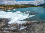
Hike to Confluencia Rio Baker & Nef, Chile
The confluence of the Baker River is formed from the union of the Neff and Baker rivers. The drop of over 10 meters high, creates a huge waterfall and a sharp contrast between the turquoise waters of Baker River and the milky waters of Nef River. -
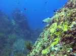
Dive or Snorkel Congo Cay, U.S. Virgin Islands (USVI)
The Congo dive site is located just off of St. Thomas, USVI. It's one of the most frequently dived site on the North side of the island due to its very colorful scenery, rock formations, and larger fish. The West End of Congo Cay has great snorkeling in calm conditions. -
Hike Congost de Mont-Rebei Gorge, Spain
Dramatic 1,480-acre reserve on an impressive gorge along the Noguera Ribagorzana river with oak forests inhabited by eagles & vultures. Along the way you have to climb stairs, cross bridges, walk on asphalt and on dirt and stone tracks. The Congost is that it links up with the spectacular Montfalcó footbridges. -
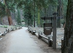
Hike Congress Trail, Sequoia National Park, California
Congress Trail is a 2.7 mile round-trip lollipop-shaped trail on a gentle, paved incline. It begins near the General Sherman Tree, the largest living tree on Earth. Along the path, you'll also see excellent examples of mature sequoias, including the House and Senate groups, and the President Tree. For accessible access to the Congress Trail and General Sherman Tree, p... -
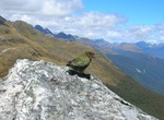
Hike to Conical Hill (Routeburn Track), New Zealand
Conical Hill (1515m) is the highest point of Routeburn Track. It's a popular side trip off the main track from Harris shelter. It offers a 360 degree view of the area. -
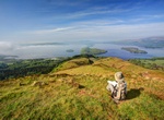
Hike Conic Hill, Stirling, Scotland
Conic Hill (from Gaelic "còinneach" meaning moss) is a prominent hill in Stirling, Scotland. It is on the east bank of Loch Lomond, beside the village of Balmaha. It is a sharp little summit which is on the Highland Boundary Fault. There was a tiny cairn at the top (361 m or 1,184 ft); as of February 2019[update] there is only a scattering of stones to mark the... -
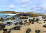
Go Coasteering Connemara Coast, Galway, Wild Atlantic Way
The Wild Atlantic Way (Irish:Slí an Atlantaigh Fhiáin) is a tourism trail on the west coast, and on parts of the north and south coasts, of Ireland. The 2,500 km (1,553 mile) driving route passes through nine counties and three provinces, stretching from County Donegal's Inishowen Peninsula in Ulster to Kinsale, County Cork, in Munster, on the Celtic Sea... -
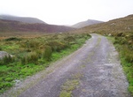
Drive Conor Pass, Dingle Peninsula, Ireland
The Conor Pass is the highest mountain pass in Ireland. It is situated on the Dingle Peninsula in County Kerry, on the road that crosses the peninsula between Dingle Town and the coast the other side. The road which runs from Dingle on the south-western end of the peninsula towards Brandon Bay and Castlegregory in the north-east The Mountains the Pass crosses are the... -
Wine Tasting in Constantia Valley, Cape Town, South Africa
From Cape Town drive the M3 south to the historic wine-growing Constantia Valley, with rolling vine-covered hills surrounding you all the way. Constantia is a suburb of Cape Town, South Africa, situated about 15 kilometres south of the centre of Cape Town. The Constantia Valley lies to the east of and at the foot of the Constantiaberg mountain. The area is a major tou... -
Walk along Constitution Avenue, Washington, D.C.
In Washington, D.C., Constitution Avenue is a major east-west street running just north of the United States Capitol in the city's Northwest and Northeast quadrants. The avenue carries heavy commuter traffic on weekdays and heavy tourist traffic on the weekends; it is also an important parade route. In Northwest Washington, Constitution Avenue separates the National M... -
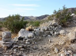
Hike Contact Mine Trail, Joshua Tree National Park, California
Contact Mine Trailhead is located off Utah trail near North Entrance Station of Joshua Tree National Park. Bill McHaney mentioned in 1910 that he and Phil Sullivan built an arrastra near The Palms to work ore from Sullivan's Contact Mine. A June 25, 1941 report of the Devision of Investigations states that the Contact and Contact #2 mining claims had been located July... -
Hike Continental Divide Trail (CDT)
The Continental Divide National Scenic Trail (in short Continental Divide Trail) is a United States National Scenic Trail running 3,100 miles (5,000 km) between Mexico and Canada. It follows the Continental Divide along the Rocky Mountains and traverses five U.S. states — Montana, Idaho, Wyoming, Colorado, and New Mexico. In Montana it crosses Triple Divide Peak... -
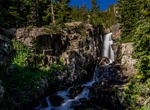
Hike to Continental Falls, Breckenridge, Colorado
Continental Falls is a moderate 2.5 mile hike to the largest waterfall near Breckenridge Colorado. It included within the Camp Hale-Continental Divide National Monument.


Price: $106.33