Give us feedback!


 See all

Our philosophy is simple. We want to encourage you to dream. BIG! Then we help you plan your trip, get the most out of it while you're traveling and help you share your experience with friends.
Join Now It's FREE
Dream Packages
Duration: 2 days
Price: $469.00
Price: $469.00
Duration: 6 days
Price: $606.00
Price: $606.00
Duration: 8 hours
Price: $220.83
Price: $220.83
Duration: 9 hours
Price: $109.14
Price: $109.14
Dreams Still To Do
Checked-Off Dreams
Dreams Still To Do
Checked-Off Dreams
Advertisement
Explore Adventure Sports
-
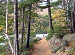
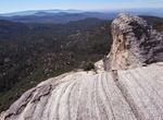
Hike Deer Brook Trail via Jordan Pond Path, Acadia National Park, Maine
Deer Brook Trail via Jordan Pond Path is a 5.1 mile out and back trail located near along and to the norht east of Jordon Pond. Dogs are also able to use this trail but must be kept on leash. -
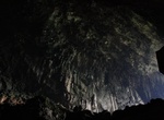
Explore Deer Cave (Gua Rusa), Malaysia (UNESCO site)
Deer Cave (Gua Rusa), located near Miri, Sarawak, Malaysian Borneo, is a show cave attraction of Gunung Mulu National Park. It was surveyed in 1961 by G.E. Wilford of the Malaysian Geological Survey, who predicted that Mulu would yield many more caves in the future (Wilford, 1964). The cave, which is also known asGua PayauorGua Rusaby the local Penan and Berawan peopl... -
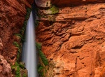
Hike to Deer Creek Falls, Grand Canyon National Park, Arizona
Deer Creek and its waterfall are a popular stopping point for river trips through the Grand Canyon at Colorado Rover Mile 136.9. It's popular for both for the falls themselves and for hikes up to the "narrows" and the "throne room." The Thunder River-Deer Creek Loop is a 21.5-mile clockwise loop in Grand Canyon National Park that put together faint trails and bunch of... -
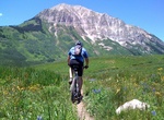
Mountain Bike Deer Creek Trail, Crested Butte, Colorado
Deer Creek Trail is a 23.3 mile out and back trail located near Crested Butte, Colorado. -
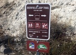
Hike or Ride Deerfield BMX Loop Trail, Mission Trails Park, San Diego, California
Hike or mountain bike the Deerfield BMX Loop Trail in Mission Trails Regional Park. Either start at the Visitor Center or from the San Diego River Crossing Staging Area. It's mile oout and back from visitor center. -
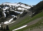
Hike Deer Park-Obstruction Point Trail, Olympic National Park, Washington
7.4 mile trail through Obstruction Point: subalpine forests and moutain meadows. The trail starts at 5,380 feet and ends at 6,150, with a high point at 6,650. -
Drive Deer Park Road, Olympic National Park, Washington
The 18-mile Deer Park Road is narrow and steep with occasional turn-offs. The last 9 miles are gravel. It is not suitable for RVs or trailers. Please use caution. From late fall until melt out in late spring, the road is closed at the park boundary, about 9 miles from Highway 101. Deer Park Ranger Station is intermittently staffed during summer and fall. Informat... -
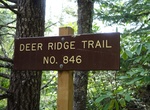
Hike Deer Ridge Trail, Olympic National Park, Washington
Deer Ridge Trail starts at Three Forks Trail and splits after 0.2 mile. Dropping 400 feet, the first 1.5 miles take you to the park boundary. The trail continues for another 3.1 miles to Slab Camp, in Olympic National Forest. Total elevation loss is 2,856 feet. There is a restroom near the trailhead. -
Hike Deer Springs Trail To Suicide Rock, San Jacinto Mountain, California
The hike to Suicide Rock in the San Jacinto Mountains along Deer Springs Trail is a good mix of forest, rocks and views. The trail to Suicide Rock is a branch off Deer Springs Trail. This 6.5 mile roundtrip hike is somewhat challenging due to rocks and elevation. It starts at 5,600 ft and ends at 7,300 ft. About a half mile up the Deer Springs trail you will enter int... -
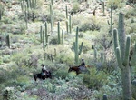
Hike or Ride Deer Valley Loop, Saguaro National Park, Arizona
From the trailhead, proceed south on Wildhorse Trail. After crossing Bajada Wash enjoy the views of upland saguaro forest. Horse riding has been traditional here since the early 1900’s among residents & visitors. At the triple trail junction bear right on Garwood Trail. Unusual saguaros seen in this area have included a 4-trunker, a cluster of 13 (at first ... -
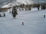
Ski Deer Valley Resort, Utah
Deer Valley is an alpine ski resort in the Wasatch Range, located 36 miles (58 km) east of Salt Lake City, in Park City, Utah, United States. The resort, known for its upscale amenities, is consistently ranked among the top ski resorts in North America. It is also one of the world's few remaining ski resorts that prohibit snowboarding. With a number of other large ski... -
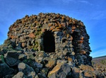
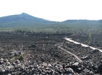
Visit Dee Wright Observatory, Oregon
Dee Wright Observatory is an observation structure at the summit of McKenzie Pass in the Cascade Mountains of Oregon. The structure is an open shelter constructed with lava stone. It is located in the midst of a large lava flow, and offers an exceptional view of numerous Cascade peaks. Dee Wright Observatory is located in the Willamette National Forest 15 miles (24 km... -
Hike Dee Wright Observatory Lava Trail, Oregon
Dee Wright Observatory, built completely of lava rocks, offers fantastic views to all the surrounding volcanoes. Following the loop trail through the lava field you will feel like you are in moon landscape. It's hard to believe that this much lava erupted from the earth around you! Make sure you take the time to read all the interesting interpretive signs on the trail... -
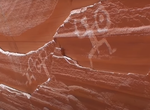
Boat & Hike to Defiance House (Forgotten Canyon), Lake Powell, Utah
Defiance House is located in Forgotten Canyon on Lake Powell. Defiance House is named after the warrior pictographs on the cliff above the ruin. Defiance House was occupied by Anasazi (Ancestral Puebloans) from approximately A.D. 1250 to 1285. Take a boat from Bullfrog, approximately. 40 minutes,15 miles (24 km) by water. Boat into Forgotten Canyon as far as lake leve... -
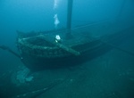
Wreck Dive Defiance Shipwreck, Thunder Bay, Michigan
During the 1850s, the push for speed on the Great Lakes led to more wrecks than ever before. In the fall of 1854, ship owners and sailors reeled from the most costly season to date: 119 lives, 70 ships, and $2 million in property losses. Defiance and John J. Audubon were victims of that dangerous year. On October 20, 1854, Audubon sailed ...
Price: $180.00