Give us feedback!


 See all

Our philosophy is simple. We want to encourage you to dream. BIG! Then we help you plan your trip, get the most out of it while you're traveling and help you share your experience with friends.
Join Now It's FREE
Dream Packages
Duration: 3 hours
Price: $180.00
Price: $180.00
Duration: 8 hours
Price: $83.37
Price: $83.37
Duration: 9 hours
Price: $109.14
Price: $109.14
Duration: 6 days
Price: $606.00
Price: $606.00
Dreams Still To Do
Checked-Off Dreams
Dreams Still To Do
Checked-Off Dreams
Advertisement
Explore Adventure Sports
-
Swim or Dive in the Devils Punch Bowl, Olympic National Park, Washington
The "Devils Punch Bowl" is a popular swimming and diving area on Lake Crescent in Olympic National Park, Washington. It can be accessed from the Spruce Railroad Trail. -
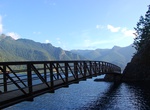
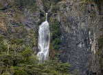
Hike to Devils Punchbowl Falls, Arthur's Pass, New Zealand
Devils Punchbowl Waterfall in Arthur's Pass National Park is spectacular fall (131 metres) that can be seen from the main road, but a walk to the base of the waterfall is well worth it. Start at the Punchbowl car park (signposted off the highway) and hike to the bridge over Devils Punchbowl Creek, which has a good view of the waterfall. Then take a series of steps cl... -
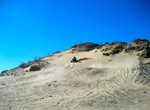
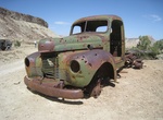
ATV Devil's Slide, Ocotillo Wells SVRA, California
Devil's Slide is a 200 foot-high granite and sand island in Ocotillo Wells Recreation Area named for the challenge it presents to the OHV enthusiast. It is actually an ancient decomposing mountaintop. A dark coat of desert varnish covers the rocks as a result of exposure to sunlight. There are several old hidden mine shafts along the mountainside. The mines are said t... -
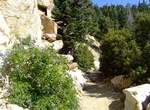
Hike Devil's Slide to Saddle Junction Trail, San Jacinto Mountain, California
The Devil's Slide to Saddle Junction Trail is located in the San Jacinto Mountain near Idyllwild, California. It's a moderate 2.4 mile one-way trail. The Devil's Slide Trail continues on to San Jacinto peak. This is 16 miles and elevation gain of 4,200 feet. While it is a longer way to get to the top that the tram route or the Marion Mountain Trail, the effort is mor... -
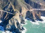
Hike or Ride Devil's Slide Trail, California
Devil’s Slide Trail is a 1.3-mile multi-use trail, converted from a former segment of Highway 1, that gives hikers, runners, bicyclists and equestrians access the rocky heights of Devil’s Slide above the Pacific Ocean. At provided overlooks, trail users may rest on benches and gaze through observation scopes and take in the view of the rocky coastal waters... -
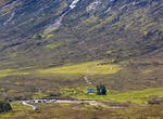
Hike Devil's Staircase, Scotland
The Devil's Staircase in Scotland is a section of the West Highland Way, a popular long-distance hiking route. It's known for its challenging, zig-zagging ascent and descent, particularly between Glencoe and Kinlochleven. The name, given by soldiers in the 18th century, reflects the difficulty of carrying materials up the path. Despite the name, many hikers find it a ... -
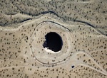
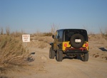
Off-road to Devils Throat, Gold Butte National Monument, Nevada
Devils Throat is a sinkhole in the middle of the open desert in Gold Butte National Monument, Nevada. It has chain-link fence that surrounds the sink hole. From The Cistern (Whitney Pockets), drive south on Gold Butte Road for 7.25 miles to a signed turnoff to Devils Throat and the Red Bluff Byway. -
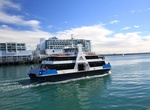
Ride Ferry to Devonport, New Zealand
Devonport is a harbourside suburb of Auckland, New Zealand. It is located on the North Shore, at the southern end of a peninsula that runs southeast from near Lake Pupuke in Takapuna, forming the northern side of the Waitemata Harbour. East of Devonport lies North Head, the northern promontory guarding the mouth of the harbour. The suburb hosts the Devonport Naval Bas... -
Off-road to Dexter #7 Mine at Calf Mesa, San Rafael Swell, Utah
The old Dexter 7 mine is near the south end of Calf Mesa in the northern part of the San Rafael Swell. From 1950 through 1957 the mine produced more than 500 tons of ore which averaged about 0.20 percent U308 and 0.05 percent V205. -
Off-road to Diablo Drop-Off (Arroyo Seco Del Diablo), Anza-Borrego Desert State Park, California
Arroyo Seco Del Diablo is a trail through Anza-Borrego Desert State Park to get from S2 to Fish Creek via Vallecito Creek Road. High clearance 4WD required. There are two very narrow sections and many areas requiring high clearance. The Diablo Drop-off section of the trail is ONE-WAY going south-to-north. There are a few primative campsite along the road that are... -
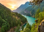
Explore Diablo Lake, Washington State
Diablo Lake is a reservoir in the North Cascade mountains of northern Washington state, United States. Created by Diablo Dam, the lake is located between Ross Lake and Gorge Lake on the Skagit River at an elevation of 1,201 feet (366 m) above sea level. Diablo Lake is part of the Skagit River Hydroelectric Project and managed by Seattle City Light. Diablo Lake Trail, ... -
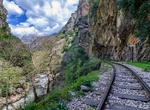
Ride Diakofto–Kalavryta Railway, Greece
The Diakofto–Kalavryta Railway is a historic 750 mm (2 ft 5 1⁄2 in) gauge rack railway in Greece. Located on the northern Peloponnese, it runs 22 km (14 mi) from Diakopto through the Vouraikos Gorge and the old Mega Spilaion Monastery and up to Kalavryta, stopping en route at Zachlorou. The line was built by the Piraeus, Athens and Peloponnese Railways (SP... -
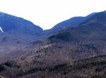
Summit Dial Mountain, New York
Dial Mountain is a mountain located in Essex County, New York. The mountain is part of the Colvin Range. Dial Mountain is flanked to the southwest by Nippletop. It is one of the 46 Adirondack High Peaks and is located in the Adirondack Park. Dial Mountain stands within the watershed of Lake Champlain, which drains into Canada's Richelieu River, the Saint Lawrence Riv... -
Visit Diamond Cay National Park, British Virgin Islands (BVI)
Diamond Cay is a tiny islet located just off Jost Van Dyke in the British Virgin Islands. Diamond Cay National Park is a perfect stop for those wanting to enjoy the best life both in and out of the water. There are 10 mooring a few hundred yards off shore for overnight visits. -
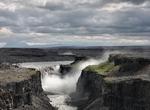
Drive Diamond Circle, Iceland
The Diamond Circle is a popular tourist route around Húsavík and Lake Mývatn in North Iceland. The four primary stops on the route are The town of Húsavík, Ásbyrgi Canyon, Lake Mývatn and Dettifoss Waterfall, the most powerful waterfall in Europe. Other stops include Vatnajökull National Park, Goðafoss Waterfal...

Price: $99.36