Give us feedback!


 See all

Our philosophy is simple. We want to encourage you to dream. BIG! Then we help you plan your trip, get the most out of it while you're traveling and help you share your experience with friends.
Join Now It's FREE
Dream Packages
Duration: 8 hours
Price: $83.37
Price: $83.37
Duration: 3 hours
Price: $180.00
Price: $180.00
Duration: 6 days
Price: $606.00
Price: $606.00
Duration: 5 hours
Price: $106.33
Price: $106.33
Dreams Still To Do
Checked-Off Dreams
Dreams Still To Do
Checked-Off Dreams
Advertisement
Explore Adventure Sports
-
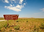
Drive to Anticline Overlook (Hatch Point Road), Moab, Utah
The Anticline Overlook is named for the curved, uplifted Kane Creek Anticline visible across the Colorado River to the north. About 5200 feet of salt-baring rocks, remnants from ancient seas, lie beneath the Kane Creek anticline in the Paradox Member of the Hermosa Formation. The Intrepid Potash mining facility and solar evaporation ponds are visible from the overlook... -
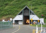
Drive through Anton Anderson Memorial Tunnel (Whittier Tunnel), Alaska
The Anton Anderson Memorial Tunnel, often called the Whittier Tunnel after the town at its eastern terminus, is a dual-use ("bimodal") highway and railroad tunnel that passes under Maynard Mountain. At a length of 13,300 ft (4,100 m), it is the second-longest highway tunnel and longest combined rail and highway tunnel in North America. The tunnel was upgraded to bimod... -
Dive Antonio López, Puerto Rico
Antonio López, also known as SS ANTONIO LÓPEZ Shipwreck Site and Remains, in Puerto Rico. It is one of Puerto Rico's 63 National Historic Landmarks. The "Antonio López" was a transoceanic steamer belonging to the Compañía Transatlántica Española named after its founder Antonio López y López. The ship was b... -
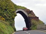
Drive Antrim Coast Road, Northern Ireland
The A2 is a major road in Northern Ireland, a considerable length of which is often referred to the Antrim Coast Road because it follows the scenic coastline of County Antrim. Mainly a single lane in each direction, the road follows most of the coastline of Northern Ireland. It is connected in several places to other major roads. The Antrim Coast Road is regarded as o... -
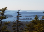
Hike Anvil Trail, Schoodic Peninsula, Acadia National Park, Maine
Anvil Trail is a moderate, 1.1 miles (1.8 km) trail in Schoodic Peninsula, Acadia National Park, Maine. Rocky and steep sections mark this trail up the southeastern side of Schoodic Head. -
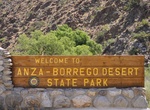
Explore Anza-Borrego Desert State Park, California
Anza-Borrego Desert State Park is a state park located within the Colorado Desert of Southern California. The park takes its name from 18th century, Spanish explorer Juan Bautista de Anza and borrego, the Spanish word for bighorn sheep. With 600,000 acres (2,400 km2) that include one-fifth of San Diego County, Anza-Borrego is the largest state park in California and, ... -
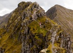
Hike Aonach Eagach Ridge, Scotland
The Aonach Eagach is a rocky ridge lying to the north of Glen Coe in the Scottish Highlands, boasting two Munro summits. In length the full ridge continues for 10 km from the Pap of Glencoe at the west to the eastern end at theDevil's Staircase. The central section, some 2 km in length, is very rocky and the route along it requires scrambling ability. The slopes to ea... -
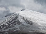
Ski or Hike Aonach Mòr, Scotland
Aonach Mòr is a mountain in the Highlands of Scotland. It is located about 2 miles/ 3 km north east of Ben Nevis on the south side of Glen Spean, near the town of Fort William . The Nevis Range ski area is located on the northern slopes of the peak; the use of this name has inspired some controversy, as it has been considered by some to represent a deliberate c... -
Visit Ao Nang, Thailand
Ao Nang is a small resort town and subdistrict in the Mueang Krabi District of Krabi Province, Thailand. Ao Nang is a central point of the coastal province of Krabi, Thailand. The town consists chiefly of a main street, which is dominated by restaurants, pubs, shops and other commerce aimed at tourists. The main beach is used by sunbathers to a certain extent, but the... -
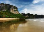
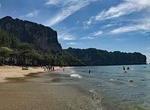
Relax at Ao Nang Beach, Krabi, Thailand
Ao Nang is a popular beach near Krabi town. There are always many tourists and music playing so if you want to have fun it's a place for you. -
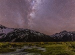
Visit Aoraki Mackenzie International Dark Sky Reserve, New Zealand
The Aoraki Mackenzie International Dark Sky Reserve is an area of 4,367 km2 (1,686 sq mi) that was designated as an International Dark Sky Reserve by the International Dark-Sky Association in June 2012. The reserve is located in the Mackenzie District in the South Island of New Zealand. At the time of the designation in 2012, the reserve was the largest in the world, ... -
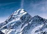
Summit Aoraki/Mount Cook, New Zealand
Aoraki / Mount Cook is the highest mountain in New Zealand, reaching a height of 3,754 metres (12,316 ft). It lies in the Southern Alps, the mountain range which runs the length of the South Island. A popular tourist destination, it is also a favourite challenge for mountain climbers. Aoraki / Mount Cook consists of three summits lying slightly south and east of the m... -
Hike to Apache Falls, Arizona
Apache falls is located in Salt River Canyon along US 60. It's on native land so make sure to grab a permit (Carrizo Gas Station offers them) -
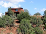
Hike Apache Fire Loop, Red Rock State Park, Arizona
The Apache Fire Loop starts off at the Bunkhouse Trailhead, which is located just south of Red Rock State Park Miller Visitor Center. Cross Oak Creek and head up the hill to connect to House of Apache Fire Trail. Then turn right onto Apache Fire Trail and eventually head back down the ridge and cross back over Oak Creek back to the visitor center. -
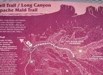
Hike Apache Maid Trail No. 15, Sedona, Arizona
The 9.5-mile (15.3 km) Apache Maid Trail branches off of the Bell Trail after 2.5 miles and ascends the northern canyon wall of the Wet Beaver Wilderness through a series of switchbacks. The rest of the trail then levels out across one of the plateaus of the Mogollon Rim. Hikers will find picturesque views of Wet Beaver Creek Canyon and hillsides of prickly pear cacti...

Price: $469.00