Give us feedback!


 See all

Our philosophy is simple. We want to encourage you to dream. BIG! Then we help you plan your trip, get the most out of it while you're traveling and help you share your experience with friends.
Join Now It's FREE
Dream Packages
Duration: 15 hours
Price: $149.00
Price: $149.00
Duration: 8 hours
Price: $220.83
Price: $220.83
Duration: 2 days
Price: $242.00
Price: $242.00
Duration: 4 hours
Price: $120.43
Price: $120.43
Dreams Still To Do
Checked-Off Dreams
Dreams Still To Do
Checked-Off Dreams
Advertisement
Explore Adventure Sports
-
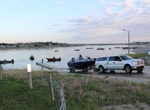
Explore Fort Stevenson State Park, North Dakota
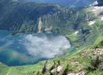
Fort Stevenson State Park is a state park in McLean County, North Dakota, south of the community of Garrison. The park occupies a peninsula on the north side of Lake Sakakawea and offers fishing, boating, camping, and picnicking. Ft. Stevenson State Park is known as the walleye capital of North Dakota. A favorite spot for sportsmen to experience the great fishing on t... -
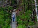
Hike Fort to Sea Trail, Oregon
The "Fort to Sea Trail" follows the 6.5 mile route used by the Lewis and Clark Expedition when hiking from Fort Clatsop to the Pacific Ocean, ends at Sunset Beach. Explore the forests, travel along the coastal rivers and lakes, and traverse the coastal dunes. The Fort To Sea Trail starts from the Visitor Center at Fort Clatsop. The first two miles take you up a gentl... -
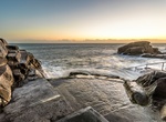
Swim Forty Foot, Dublin, Ireland
The Forty Foot is a promontory on the southern tip of Dublin Bay at Sandycove, County Dublin, Ireland, from which people have been swimming in the Irish Sea all year round for some 250 years. In former times it was exclusively a gentlemen's bathing place and the gentlemen's swimming club was established to help conserve the area. Owing to its relative isolation and ge... -
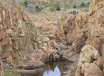
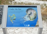
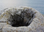
Hike to Forty Foot Hole, Wichita Mountains Wildlife Refuge, Oklahoma
Forty Foot Hole is a canyon formed by West Cache Creek in the Wichita Mountains Wildlife Refuge in Oklahoma. After exiting Forty Foot Hole, the creek flows on a plain for half a mile before entering another canyon known as The Narrows. -
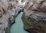
Hike Fortymile Gulch & Willow Gulch, Utah
Fortymile Gulch and Willow Gulch are tributaries of the Escalante River, located in Kane County in southern Utah, in the western United States. With a combined length of over 20 miles (30 km), they exhibit many of the geologic features found in the Canyons of the Escalante, including high vertical canyon walls, water pools, narrow slot canyons, domes, and arches. Popu... -
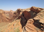
Hike Fortymile Ridge to Crack in the Wall into Coyote Gulch, Utah
One of the best ways to hike into Coyote Gulch is via the Crack in the Wall. There are outstanding views from the canyon rim by hiking from Fortymile Ridge to Crack-in-the-Wall. After scrambling down through the crack - a narrow route between the cliff face and huge rock slabs which have peeled off the cliff - a trail leads down a steep sand dune to lower Coyote Gulch... -
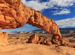
Hike Fortymile Ridge to Sunset Arch, Utah
The trailhead to Sunset Arch is located at mile 33.8 along the Hole in the Rock Trail in Utah. Fromt here take Hurricane Wash south for another 2.2 miles to the signed turnoff to Fortymile Ridge, then turn left (northeast) to reach the trailhead. It's an easy 2.8 miles round-trip hike to the arch although it is not on an established trail. -
Explore Fortymile Wild and Scenic River, Alaska
The Fortymile River is an extensive network of creeks and rivers in east-central Alaska, 392 miles of which are designated a National Wild and Scenic or Recreational River. The river's numerous forks flow into the 'mainstem' Fortymile River, which joins the Yukon River in Canada. River float trips, camping, and sightseeing from the Taylor Highway are the primary attr... -
Summit Forum Peak, Waterton Lakes National Park, Alberta, Canada
Forum Peak is a summit located on the border of Alberta and British Columbia on the Continental Divide. It is the southernmost mountain in the Canadian Rockies, situated only 500 metres north of the Canada–United States border. It was named after Forum Lake below the mountain. It is visible from the end of Highway 5 at Cameron Lake, which is within Waterton Lake... -
Off-road & Hike Fossil Canyon, Coyote Mountains Wilderness, California
Fossil Canyon is rocky and high walled, starting out narrow but widens considerably further up. Start at Sheep Canyon Rd from S2 and turn right up the canyon road to the barrier. The dirt road is good, but you need a bit of ground clearance. -
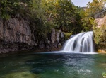
Hike Fossil Creek Waterfall Trail, Arizona
Waterfall Trail is the most popular area at Fossil Creek. The one-mile trail follows the creek to a natural waterfall, where crowds spend the day swimming. This rewarding hike showcases the beauty Fossil Creek has to offer. However, swimming and cliff diving near the waterfall is extremely dangerous, and has led to several drowning deaths and severe injuries. Fossil C... -
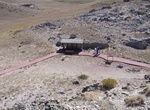
Hike Fossil Discovery Trail (Dinosaur Quarry Trail), Dinosaur National Monument, Utah
This 1.2 mile (2 km), one-way trail cuts through several tilted rock layers which expose a variety of rocks and three fossil areas as offshoots of the main trail. The Morrison Formation stop features an outcropping of several small fossil fragments and a few large pieces of dinosaur bones in their natural state, just as Earl Douglass found them in 1909. Trailheads are... -
Hike Fossil Exhibit Trail, Badlands National Park, South Dakota
Fully accessible boardwalk trail features fossil replicas and exhibits of now extinct creatures that once roamed the area. -
Hike to Fossil Forest, Dorset, England
The Fossil Forest is the remains of an ancient submerged forest from Jurassic times, located to the east of Lulworth Cove on the Isle of Purbeck in Dorset, England. It lies on the Jurassic Coast, on a wide ledge in the seaside cliff. The site is within the Lulworth Ranges and thus has restricted access. Parts of forest can also be seen on the Isle of Portland and in q... -
Hike Fossil Hills Trail, Agate Fossil Beds National Monument, Nebraska
This 2.7-mile (4.3-km) wheelchair-accessible paved trail begins at the visitor center. From the visitor center, the trail crosses the Niobrara River and its wetlands, passes through ecologically intact short- and mixed-grass prairie, and then loops around University and Carnegie Hills. It was on these hills that future local rancher James Cook discovered fossilized bo...
Price: $109.14