Give us feedback!


 See all

Our philosophy is simple. We want to encourage you to dream. BIG! Then we help you plan your trip, get the most out of it while you're traveling and help you share your experience with friends.
Join Now It's FREE
Dream Packages
Duration: 8 hours
Price: $83.37
Price: $83.37
Duration: 8 hours
Price: $208.72
Price: $208.72
Duration: 4 hours
Price: $120.43
Price: $120.43
Duration: 8 hours
Price: $220.83
Price: $220.83
Dreams Still To Do
Checked-Off Dreams
Dreams Still To Do
Checked-Off Dreams
Advertisement
Explore Adventure Sports
-
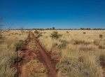
Off-road Gary Highway, Western Australia
The Gary Highway is a remote unsealed track in central Western Australia running through the Gibson Desert and the Great Sandy Desert. It was built by Len Beadell's Gunbarrel Road Construction Party in April and May 1963 and named after Beadell's son who was born in February that year. It connects the Gunbarrel Highway from Everard Junction in the south, to the Gary J... -
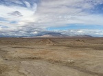
Off-road Gas Domes Trail, Ocotillo Wells SVRA, California
These mysterious waterholes produce large gas bubbles that rise up through muddy water. The water travels to the surface, emerging through a natural crack in the desert floor. Amazingly, this weird waterhole stays wet year-round. This “crown jewel” of Ocotillo Wells also offers views of the Salton Sea. There is an artizian well about 0.9 miles to the south... -
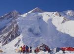
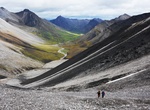
Summit Gasherbrum II, Pakistan
Gasherbrum II, also known as K4, is the 13th highest mountain on Earth, located on the border of Gilgit–Baltistan province, Pakistan and Xinjiang, China. At 8,035 metres (26,362 ft), Gasherbrum II is the third highest peak of the Gasherbrum massif, located in the Karakoram range of the Himalaya. The standard climbing route is via the southwest ridge as it is rel... -
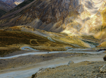
Drive Gata Loops, Leh–Manali Highway, India
Gata loops on Leh–Manali Highway involves climbing 500 m through the 21 hairpin bends at 4,190 m (13,750 ft) elevation. -
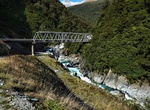
See Gates of Haast Waterfall & Bridge, Mt Aspiring National Park, New Zealand
Gates of Haast Waterfall, Mt Aspiring National Park, New Zealand -
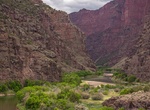
Raft or Kayak Gates of Lodore (Green River), Dinosaur National Monument, Colorado
The Gates of Lodore is the scenic entrance to the Canyon of Lodore, a canyon on the Green River in northwestern Colorado, United States. The name Gates of Lodore has become synonymous with the canyon itself and the two names are used interchangeably. The Canyon commences as the Green River departs Browns Park and cuts through the Uinta Mountains meandering eighteen mi... -
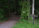
Hike Gates of Lodore Trail, Dinosaur National Monument, Colorado
The trail starts with a few steps and then is a level walk above the Green River. The trail ends at a view of the entrance to Lodore Canyon.Length: ¾ mile one way / 1.5 mile round trip. Not a loop.Level of Difficulty: Easy. The trail is gravel and even terrain for most of the hike.Trailhead Location: Located at the Gates of Lodore Campground at the north end of... -
Explore Gates of the Arctic National Park, Alaska
Gates of the Arctic National Park and Preserve is a U.S. National Park in Alaska. It is the northernmost national park in the U.S. (the entirety of the park lies north of the Arctic Circle) and the second largest at 13,238 mi² , about the same size as Switzerland. The park consists primarily of portions of the Brooks Range of mountains. It was first protected as ... -
Hike or Ride Gateway Loop Trail, McDowell Sonoran Preserve, Arizona
A 4.5 mile loop that wanders up to a low saddle before winding back to the Gateway Trailhead. The length and grade changes make this a moderately difficult hike, but one worth trying. Make your way at an enjoyable pace while enjoying the wildflowers and wildlife. Kids with hiking experience may be able to enjoy this hike. Follow the main trail from the parking area t... -
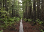
Hike or Ride Gatlinburg Trail, Great Smoky Mountains, Tennessee
The Gatlinburg Trail is one of two walking paths on which visitors can walk dogs and bicycle. Pets and bicycles are prohibited on all other park trails. The trail travels 1.9 miles one-way from the Sugarlands Visitor Center to the outskirts of the city of Gatlinburg, TN. It is relatively flat and runs through the forest along side the West Prong of the Little Pigeon R... -
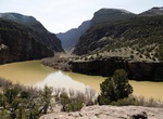
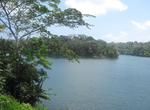
Dive Gatun Lake, Panama Canal, Panama
Gatun Lake (Lago Gatún) is a large artificial lake situated in the Republic of Panama; it forms a major part of the Panama Canal, carrying ships for 33 km (21 mi) of their transit across the Isthmus of Panama. The lake was created between 1907 and 1913 by the building of the Gatun Dam across the Chagres River. At the time it was created, Gatun Lake was the larg... -
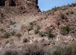
See Gauger's Residence Site (Black Canyon), Arizona
This landmark can only be reached by water, so grab your kayak or raft and head down Black Canyon, or boat over from Willow Beach. Gauger’s residence was the home of the person who operated the gauging station located further upstream. The original structure was demolished, but you can still see a few of the concrete foundations along the terraced hillside. Ther... -
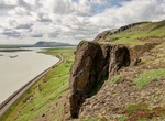
See view from Gaukshöfði, Iceland
It's an easy walk or 4x4 drive up to Gaukshöfði at the top of the hill. Provides great views of the Þjorsárdalur valley. -
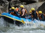
Raft or Kayak Gauley River National Recreation Area, West Virginia
The 25 miles of free-flowing Gauley River and the six miles of the Meadow River pass through scenic gorges and valleys containing a wide variety of natural and cultural features. The Gauley River contains several class V+ rapids, making it one of the most adventurous white water boating rivers in the east. The Gauley River National Recreation Area, located near Summer... -
Hike Gavan Hill-Harbor Mountain Trail, Sitka, Alaska
The Gavan Hill trailhead is located at the end of Baranof Street. A broad gravel path leads into the forest, where the trail briefly intersects with the Sitka Cross Trail and then cuts straight up the side of Gavan Hill. The ascent is steep – about 2,000 feet in less than 2 miles – and spent mainly on wooden stairs. A mile in, there is a viewing platform t...

Price: $179.00