Give us feedback!


 See all

Our philosophy is simple. We want to encourage you to dream. BIG! Then we help you plan your trip, get the most out of it while you're traveling and help you share your experience with friends.
Join Now It's FREE
Dream Packages
Duration: 7 hours
Price: $179.00
Price: $179.00
Duration: 3 hours 30 minutes
Price: $99.36
Price: $99.36
Duration: 15 hours
Price: $149.00
Price: $149.00
Duration: 8 hours
Price: $220.83
Price: $220.83
Dreams Still To Do
Checked-Off Dreams
Dreams Still To Do
Checked-Off Dreams
Advertisement
Explore Adventure Sports
-
Drive or Cycle Gold Belt Tour Scenic and Historic Byway, Colorado
The Gold Belt Tour Scenic and Historic Byway is a National Scenic Byway, a Back Country Byway, and a Colorado Scenic and Historic Byway located in Fremont and Teller counties, Colorado, USA. The byway is named for the Gold Belt mining region. The Cripple Creek Historic District is a National Historic Landmark. The byway forms a three-legged loop with the Phantom Canyo... -
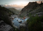
Hike to Goldbug Hot Springs, Idaho
Access to this hot springs requires a hike from the trailhead which starts at the end of the county road. The first 1/4 mile of the trail passes through private property with public access provided by an easement. Dogs must be leashed while crossing the private property. Please protect access to the hot springs by respecting private property. Located 23 miles south ... -
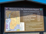
Off-road Gold Butte Rd & Gold Butte Wash Rd, Gold Butte National Monument, Nevada
Home of the very first backcountry byway, Gold Butte National Monument host’s some of the most remote landscapes of southern Nevada. The Byway begins 90 miles northeast of Las Vegas and five miles south of Mesquite/Bunkerville on Interstate 15, exit 112. The 62-mile scenic trip offers opportunities to see desert wildlife, red and white sandstone, sinkholes, pet... -
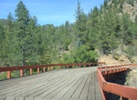
Drive Gold Camp Road, Colorado
Gold Camp Road follows the former railroad from Colorado Springs to Cripple Creek called the "Short Line". In the 1920s the railroad was converted to a car toll road, eventually becoming a free public road. In 1988, tunnel #3 collapsed and was never repaired. This portion of the road is now closed to vehicular traffic and is popular with bikers and hikers, and vehicul... -
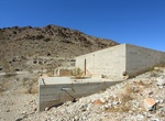
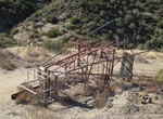
Off-road to Gold Crown Mine (Lorman Mine), 29 Palms, California
Gold Crown Mine (aka Lorman Mine) is located in the desert near 29 Palms just north of Joshua Tree National Park. The mine is a verticle mine shaft that is roughly 180 feet straight down (previous ones at 600 feet). But in this case, the mine isn't the main attraction, it is the remnants of the abandoned mining camp that still remains. With over a dozen foundations a... -
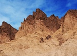
Hike Golden Canyon, Gower Gulch & Badlands Loop, Death Valley National Park, California
The Golden Canyon, Gower Gulch & Badlands Loop trail is 4.3 miles (6.9 km) and should take 2.5 to 3 hours. Golden Canyon is a short gorge that cuts into brightly colored sandstone rocks in many glowing shades of orange, gold and red, with the ever-present deep blue sky above making the hues seem especially sharp and intense. A paved road once ran the whole length ... -
Hike to Golden Chariot Mine, Banner, California
Golden Chariot Mine is location along the California Riding and Hiking Trail in the Julian Mining District, San Diego County. -
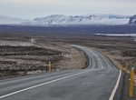
Drive Golden Circle, Iceland
The Golden Circle is a popular tourist route in South Iceland, covering about 300 km looping from Reykjavík into central Iceland and back. The three primary stops on the route are the national park Þingvellir, the waterfall Gullfoss (meaning "golden falls"), and the geothermally active valley of Haukadalur, which contains the geysers Geysir and Strokkur. ... -
Dive Golden Clouds Reef & Oracabessa Bay Fish Sanctuary, Jamaica
The reef located directly in front of Golden Clouds is one of the largest in Oracabessa Bay and is a popular dive destination due to its diverse reef structure, vibrant marine life, and close proximity to the Cayman Trough. This trough starts on the edge of the Fish Sanctuary with walls that begin at 60 ft. and drop down to over 150 ft. The walls are covered in a larg... -
Cycle across Golden Gate Bridge, San Francisco, California
No journey to San Francisco is complete without a trip to the iconic Golden Gate Bridge and there's no better to experience it than by bike. Take your time weaving through the crowds on the eastern sidewalk and enjoy the city views, or speed along on the bike-only western sidewalk and marvel at the engineering and architectural genius behind the bridge. Or better yet,... -
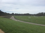
Cycle Golden Gate Park Polo Fields, California
The Polo Fields is a large multi-purpose stadium and sporting field in San Francisco's Golden Gate Park.Despite its name, polo is rarely played on the Polo Fields. The facility has a multitude of uses.There are six regulation soccer fields surrounded by a .67-mile cycle track.Wooden bleachers overlook the field and track.Above the bleachers is a 0.75-mile (1,210 m) di... -
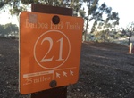
Hike Golden Hill Trails, Balboa Park, San Diego, California
On the south side of the park is a gateway into three trails: The 0.5 mile trail is a frequently used loop trail bordering the road. This trail is popular with residents and lined with trees. Type: Road surface with some grass area. Difficulty level: Easy. Follow the #21 round light orange trail markers. View Google map. The 4.4 mile trail takes visitors into the na... -
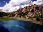
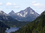
Summit Golden Hinde Mountain, BC, Canada
The Golden Hinde is a mountain located in the Vancouver Island Ranges on Vancouver Island, British Columbia, Canada. At 2,195 metres (7,201 ft), it is the highest peak on the island. The mountain is located near the geographic centre of Vancouver Island, as well as near the centre of 2,450 km2 (605,408 acres) Strathcona Provincial Park, at the head of the Wolf River a... -
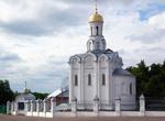
Drive Golden Ring, Russia
The Golden Ring is a ring of cities northeast of Moscow, the capital of Russia. They formerly comprised the region known as Zalesye. These ancient towns, which also played a significant role in the formation of the Russian Orthodox Church, preserve the memory of the most important and significant events in Russian history. The towns have been called "open air museums"... -
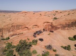
Off-road or Mountain Bike Golden Spike Safari Trail, Moab, Utah
Golden Spike is in the middle of two other difficult trails: Poison Spider and Gold Bar Rim and is one of the toughest and most time-consuming trails in the Moab area.. Golden Spike is a dream trail of challenging obstacles, which include such well-known names as the Launch Pad, Skyline Drive, the Golden Crack, the Golden Stairs, The Wall and Double Whammy. Much of th...


Price: $109.14