Give us feedback!


 See all

Our philosophy is simple. We want to encourage you to dream. BIG! Then we help you plan your trip, get the most out of it while you're traveling and help you share your experience with friends.
Join Now It's FREE
Dream Packages
Duration: 7 hours
Price: $179.00
Price: $179.00
Duration: 8 hours
Price: $220.83
Price: $220.83
Duration: 3 hours 30 minutes
Price: $99.36
Price: $99.36
Duration: 2 days
Price: $242.00
Price: $242.00
Dreams Still To Do
Checked-Off Dreams
Dreams Still To Do
Checked-Off Dreams
Advertisement
Explore Adventure Sports
-
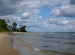
Explore Harrington Beach State Park, Wisconsin
Harrington Beach State Park is a 637-acre (258 ha) Wisconsin state park on the shore of Lake Michigan. In addition to a mile-long beach, the park contains a white cedar swamp surrounding a 26-acre (11 ha) lake which used to be a stone quarry. The Park provides campgrounds, hiking trails, picnic, and bird watch areas. -
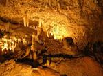
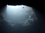
Explore Harrison's Cave, Barbados
Harrison's Cave is a tourist attraction in the country of Barbados, first mentioned in 1795. Tourists can access the subterranean environment on a tramway. The caves are naturally formed by water erosion through the limestone rock. The calcium-rich water that runs through the caves have formed the unusual stalactites and stalagmites formations. Travel through the cave... -
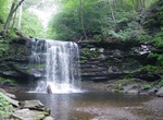
Hike to Harrison Wright Falls, Ricketts Glen State Park, Pennsylvania
Harrison Wright Falls, 27 feet (8.2 m), at Ricketts Glen State Park. It is the third of three named waterfalls on Kitchen Creek, south and downstream of Waters Meet. It is one of twenty two named waterfalls in the park, according to the Pennsylvania Department of Conservation and Natural Resources. -
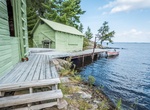
Visit Harry Oveson Fish Camp, Voyageurs National Park, Minnesota
Voyageurs National Park is offering a new boat tour on Rainy Lake this summer. Called the "Life on the Lake Tour", this boat trip explores the way people and animals have survived and thrived on and near Rainy Lake throughout the years. A highlight of the tour is the ability to get off the boat and explore Harry Oveson Fish Camp on foot. Reservations for this and all ... -
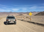
Off-road Harry Wade Rd, Death Valley National Park, California
If you are either entering or existing Death Valley National Park from the southern end (from/to Baker, California), then is a fun offroad trek that cuts off about 20 miles (instead of taking the roads). There are really no sites along this 34 mile road besides nice desert terian. The road is in good conditional and should not need 4 wheel drive except in the rain. Yo... -
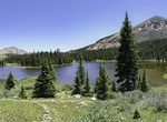
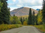
Hike to Hartenstein Lake, Colorado
A 6 mile round trip hike to Hartentstein Lake. Elevation 11,600ft. Total elevation gain 1,750ft. This trailhead is 12 miles west of Buena Vista along the Cottonwood trail. -
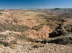
Off-road Hartnet Road, Capitol Reef National Park, Utah
The Hartnet road, or southern half of the Cathedral Valley Loop, begins 11.7 miles (18.8 km) east of the Visitor Center off Utah Hwy 24. In order to take this route to Cathedral Valley, visitors must ford the Fremont River soon after leaving the highway, which may require a high-clearance or HC4WD vehicle. The 27.8 miles (44.7 km) to the junction with Cathedral Road a... -
Off-road Hart Point Road, Utah
Harts Point Road (San Juan County Road 137) is accessed on Route 211 in the Indian Creek Recreation Area. The road is 15 miles itself, with trails leading off all along the way. Harts Point Road puts you at a higher elevation than Indian Creek. No cell service, no GPS, no wifi; make sure to have paper maps and written out directions. -
Hike to Harwoods Hole, New Zealand
At the end of Harwoods Hole Track is Harwoods Hole, the deepest vertical shaft (176 metres) in New Zealand. There is a 5.8 km out and back trail to the hole and takes about 45 minutes. A water-enlarged (but now dry) sinkhole, it drops to an underground river that emerges below and flows into Gorge Creek and then into the Takaka River. It is very dangerous to approac... -
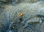
Dive Hastings Reef, Great Barrier Reef, Australia
Hastings Reef is a popular snorkelling and diving reefs and sits around 30 nautical miles outside of bustling Cairns. Flynn Reef and Norman Reef are also popular nearby reefs. -
Drive Hatcher Pass Scenic Drive, Willow, Alaska
Hatcher Pass (3,886 ft or 1,148 m) is a mountain pass through the southwest part of the Talkeetna Mountains, Alaska. It is named after Robert Hatcher, a prospector and miner. The nearest cities are Palmer and Wasilla approximately 12 miles (19 km) to the south, and Willow approximately 26 mi (42 km) to the west. The communities are at an elevation of approximately 250... -
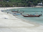
Visit Hat Rin, Ko Pha-ngan, Thailand
Hat Rin (Thai: หาดริ้น, pronounced [hàːt rín]) is a peninsular beach area and town on the southern tip of Ko Pha-ngan, an island in the Gulf of Thailand. Its two main beaches are Sunset Beach (Hat Rin Nai) to the south and the larger Sunrise Beach (Hat Rin Nok) to the north. A Full Moon Party takes place on Sunrise Beach each month. The town and beach fi... -
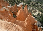
Hike Hat Shop Trail, Bryce Canyon National Park, Utah
The Hat Shop Trail is a down and back trail that begins at Bryce Point at the Peek-a-Boo Trailhead. It is not a loop. Walk down along the Under the Rim Trail to see a cluster of delicately balanced-rock hoodoos known as the Hat Shop. Although listed as a "Moderate" hike, the Hat Shop Trail should be listed as "Moderately Difficult". With a steep descent, visitors wi... -
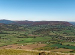
Hike Hatterrall Hill, Wales
Hatterrall Hill is a rounded peak in the Black Mountains which sits on the Wales-England border, partly in Monmouthshire, Wales and partly in Herefordshire, England. Its summit at 531m is the high point of a peaty plateau which falls away steeply on all sides. Broad ridges run to the north, the southeast and southwest. To the north the ridge (known as Hatterrall Ridge...
Price: $176.03