Give us feedback!


 See all

Our philosophy is simple. We want to encourage you to dream. BIG! Then we help you plan your trip, get the most out of it while you're traveling and help you share your experience with friends.
Join Now It's FREE
Dream Packages
Duration: 2 days
Price: $469.00
Price: $469.00
Duration: 6 days
Price: $606.00
Price: $606.00
Duration: 3 hours 30 minutes
Price: $99.36
Price: $99.36
Duration: 5 hours
Price: $106.33
Price: $106.33
Dreams Still To Do
Checked-Off Dreams
Dreams Still To Do
Checked-Off Dreams
Advertisement
Explore Adventure Sports
-
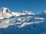
Ski or Snowboard La Plagne, Paradiski Ski Area, France
La Plagne is a French ski area in the alpine valley of the Tarentaise (Savoie). Since 2003, La Plagne and the neighbouring resort of Les Arcs form Paradiski's ski area. It is currently owned by Compagnie des Alpes. La Plagne is the most popular ski resort in the world with more than 2.5 million visitors a season on average. La Plagne lies at altitudes between 3,250 me... -
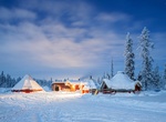
Explore Lapland Region
Lapland is a region in northern Fennoscandia, largely within the Arctic Circle. It stretches across Norway, Sweden, Finland and Russia. On the north it is bounded by the Barents Sea, on the west by the Norwegian Sea and on the east by the White Sea. The nameLaplandrefers to land inhabited by the Sami people, formerly calledLapp people, which is now considered derogato... -
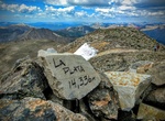
Summit La Plata Peak, Sawatch Range, Colorado
La Plata Peak is the fifth-highest summit of the Rocky Mountains of North America and the U.S. state of Colorado. The prominent 14,343-foot (4,372 m) fourteener is located in the Collegiate Peaks Wilderness of San Isabel National Forest, 22.7 miles (36.5 km) northwest by west (bearing 308°) of the Town of Buena Vista in Chaffee County, Colorado, United States. "La... -
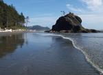
Visit La Push Beach, Washington
La Push Beach is a series of beach chains called Beach one, two, and three. Beach one is fourteen miles, beach two is thirteen, and beach three is twelve miles away from the town of Forks, located along the Pacific Coastline of Washington State, near the most western point of the continental United States. The beach’s most prominent natural growth is the Sitka, ... -
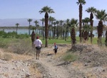
Hike La Quinta Cove to Lake Cahuilla, La Quinta, California
The La Quinta Cove to Lake Cahuilla is hike is 6 miles out and back and takes about 2-2.5 hours. You can continue to Boo Hoff Trail and make the full loop back at a total of 12.7 miles. Go in the morning, before it gets too hot, and bring plenty of water and sun protection. From Hwy 111 take Washington (South) 3 miles to Avenue 52 (Turn Right) Take Avenue 52 a 1/2 mil... -
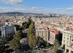
Stroll La Rambla, Barcelona, Spain
La Rambla is considered the most well known street in central Barcelona. A tree-lined pedestrian street, it stretches for 1.2 kilometres (3⁄4 mile) connecting the Plaça de Catalunya in its center with the Christopher Columbus Monument at Port Vell. La Rambla forms the boundary between the neighbourhoods of the Barri Gòtic to the east and the El Rav... -
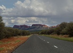
Drive Larapinta Drive (Mereenie Loop Road) B6, Northern Territory, Australia
Larapinta Drive is a 325 km (202 mi) designated state route in the Northern Territory of Australia. It forms the primary road access to the community of Hermannsburg, as well as a number of tourist attractions located west of Alice Springs, including the Alice Springs Desert Park, West MacDonnell National Park, Kings Canyon, monuments dedicated to Aboriginal artist Al... -
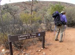
Trek Larapinta Trail, Australia
The Larapinta Trail is an extended walking track in the Northern Territory, Australia. Its total length covers 223 kilometres (139 mi) from East to West, with one end at Alice Springs and the other at Mount Sonder, one of the territory's highest mountains. It follows the West MacDonnell Ranges, sometimes along the ridge line, other times on the plain below, in the Wes... -
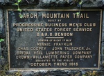
Hike Larch Mountain Trail, Oregon
The Larch Mountain Trail #441 begins near the Columbia River at the Multnomah Falls Lodge and roughly follows Multnomah Creek, passing severalwaterfalls including the well-known Multnomah Falls, Weisendanger Falls, and Ecola Falls. The trail ends at the Larch Mountain parking lot, at a picnic area. -
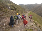
Hike Lares and Royal Inca Trail, Cusco, Peru
Avoid the crowds on and head off the beaten track on the Lares Trek—a great alternative to the Inca Trail. The Lares trek is a two or three day high altitude hike in Cusco, Peru, starting near the village Lares, approximately 40 miles north of Cusco and 35 miles east of Machu Picchu. The Lares Valley lies in the east of the Urupampa mountain range, traversing pa... -
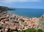
Hike La Rocca di Cefalù, Cefalù, Sicily, Italy
Hike to Castello Di Cefalù to see views of Cefalù, Sicily, Italy, -
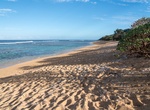
Hike to Larsen's Beach (Ka'aka'aniu Beach), Kauai, Hawaii
Larsen's Beach (aka Ka'aka'aniu Beach) is a remote and narrow 2 mile long beach on the north shore of Kauai, Hawaii. There is a offshore reef that is good for snorkeling. Since the beach is so remote, you may see some nude sunbathers. The current and reef make the beach not that safe to swim. Be very careful swimming and snorkeling. Access to the beach is along K... -
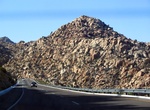
Drive La Rumorosa Highway, Baja California, Mexico
Between Tecate and Mexicali, Highway Mexico 2 winds travelers through a mountainous area with large granite boulders that make for impressive scenery and a dramatic drive. There are a number of lookouts where travelers can pull over to take in the views and snap a few photos of the sweeping vistas. About 45 minutes east of Tecate, right before starting the scenic part... -
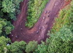
Ride La Ruta de los Conquistadores, Costa Rica
La Ruta de los Conquistadores, known as the first mountain bike race of its kind, is a multi-stage race held in Costa Rica. La Ruta de los Conquistadores consists of crossing Costa Rica from the Pacific to the Atlantic Coast in the course of three days. It an individual race, covering approximately 400 kilometers (250 miles) of terrain. First staged in 1992, the three... -
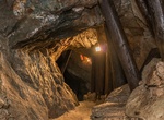
Visit Larzenbach – Hüttau Mine, Austria
The Larzenbach – Hüttau Mine dates back to the 13th/14th century. Follow the perfectly laid-out Copper Ore Path down a narrow mine tunnel. Go on a guided tour and visit the museum. Guided tours take place according to our opening hours. Only if you want to visit us outside the opening hours or as a group of 15 or more people, please register in advance. A...
Price: $109.14