Give us feedback!


 See all

Our philosophy is simple. We want to encourage you to dream. BIG! Then we help you plan your trip, get the most out of it while you're traveling and help you share your experience with friends.
Join Now It's FREE
Dream Packages
Duration: 6 days
Price: $606.00
Price: $606.00
Duration: 2 days
Price: $242.00
Price: $242.00
Duration: 3 hours
Price: $180.00
Price: $180.00
Duration: 15 hours
Price: $149.00
Price: $149.00
Dreams Still To Do
Checked-Off Dreams
Dreams Still To Do
Checked-Off Dreams
Advertisement
Explore Adventure Sports
-
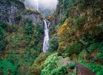
Hike to Levada das 25 Fontes & Risco, Madeira, Portugal
The Risco Waterfall ("Risco" meaning risk in English) is a group of waterfalls located in Rabaçal, Paul da Serra, in the Madeira Islands. The 25 Fontes levada name comes from the number of fountains or little waterfalls that’s possible to count once you arrive there. The Risco waterfall is 100m high, consisting of a group of different water streams comin... -
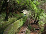
Hike along Levada Paths, Madeira
A levada (aka Levada do Rei or Kings Levada) is an irrigation channel or aqueduct specific to the Portuguese island of Madeira. The levadas originated out of the necessity of bringing large amounts of water from the west and northwest of the island to the drier southeast, which is more conducive to habitation and agriculture, such as sugar cane production. They were u... -
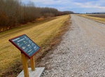
Hike or Bike Levee Trail, Ste. Geneviève, Missouri
Bike, walk, run, or roll on the 3.5 mile-long Levee Trail. You can get your heart pumping with the backdrop of the Mississippi River or enjoy a relaxed walk atop the levee while discovering nearby birds, plants and fish. From the Welcome Center turn right on Main Street. Follow Main Street for 0.5 miles, then turn right on to Division Street (AKA Stormy Crawford Wa... -
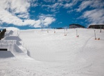
Ski or Snowboard Levi, Finland
Levi, located in Finnish Lapland, is the largest ski resort in Finland. The resort is located in Kittilä municipality and is served by Kittilä Airport and Kolari train station. At a latitude of 67.8° north, it is located approximately 170 km (110 mi) north of the Arctic Circle. The Levi fell is at an elevation of 531 metres (1742 ft) above sea level. The... -
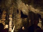
Explore Lewis and Clark Caverns State Park, Montana
Lewis and Clark Caverns State Park is located in southeastern Jefferson County, Montana. The primary feature of the park is its namesake cavern. Lewis and Clark Caverns was dissolved by slightly acidic groundwater in tilted beds of the Madison Limestone of Mississippian age. Most of the cave was probably excavated during the ice ages, a time of much greater water supp... -
Hike Lewis and Clark National Historic Trail, Illinois to Oregon
The Lewis and Clark National Historic Trail is a route across the United States commemorating the Lewis and Clark Expedition of 1804 to 1806. It is part of the National Trails System of the United States. It extends for some 3,700 miles (6,000 km) from Wood River, Illinois, to the mouth of the Columbia River in Oregon. The trail is administered by the National Park Se... -
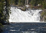
See Lewis Falls, Yellowstone National Park, Wyoming
The Lewis Falls are located on the Lewis River in Yellowstone National Park, Wyoming, United States. The falls drop approximately 30 feet (9.1 m) and are easily seen from the road, halfway between the south entrance to the park and Grant Village. The falls are on the Lewis River, just south of Lewis Lake. -
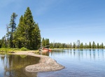
Fish Lewis Lake, Yellowstone National Park, Wyoming
Lewis Lake is located in the U. S. state of Wyoming in the southern part of Yellowstone National Park, about 4 miles (6.4 km) southeast of Shoshone Lake, and approximately 10 miles (16 km) southwest of Yellowstone Lake. Lewis Lake and Shoshone Lake are both located a few miles northeast of the Pitchstone Plateau. The Lewis River is the lake's primary inflow, drai... -
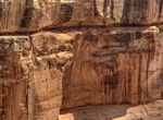
Hike to Lewis Lodge Ruins, Cedar Mesa, Utah
Lewis Lodge is a fortress perched on the edge of an 800-foot high cliff in a side canyon to Arch Canyon in Cedar Mesa are in Utah. It is one of the best Indian ruin on Cedar Mesa, Utah. ere are apporximately 44 rooms in the dwelling. The hike goes along some very exposed ledges, not good for kids or dogs. A short rope may be helpful for the hike. Note: The location ... -
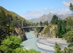
Drive Lewis Pass, New Zealand
Lewis Pass (el. 864 m.) is a mountain pass in the South Island of New Zealand. The northernmost of the three main passes across the Southern Alps, it is higher than the Haast Pass, and slightly higher than Arthur's Pass. State Highway 7 traverses the pass on its route between north Canterbury and the West Coast; it passes through extensive unmodified beech forest... -
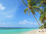
Visit Lhaviyani Atoll, Maldives
Lhaviyani Atoll or Faadhippolhu Atoll is an administrative division of the Maldives. The capital of the atoll is Naifaru. There are a total of 54 islands in the atoll of which only 5 are inhabited, namely Naifaru, Hinnavaru, Kurendhoo, Olhuvelifushi and the recently settled Maafilaafushi. The island of Maafilaafushi was resettled in the 1980s in order to relieve the l... -
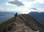
Summit Liathach (“The Grey One”), Northwest Highlands, Scotland
Liathach is a mountain in the Torridon Hills. At a height of 3,461 feet (1,055 m), it lies to the north of the A896 road, in the Northwest Highlands of Scotland, and has two peaks of Munro status: Spidean a' Choire Lèith at the east of the main ridge, and Mullach an Rathain at the western end of the mountain. The nameLiathachis pronounced [ˈʎiəhəx] in Scottish ... -
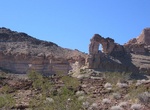
Hike Liberty Bell Arch Trail, Arizona
Want to ponder the Declaration of Independence and the ideals of freedom while you hike through the desert? We’ve got the trail for you. The Liberty Bell Arch trail has lots to see: pass an old mine, see the natural arch that looks like the Liberty Bell, and stand 700 feet above the Colorado River--all on one trail. Distance: 7 miles out and back How to Ge... -
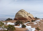
Hike Liberty Cap Trail, Colorado National Monument, Colorado
Trail ascends steeply for 2 miles from the Grand Valley floor to Liberty Cap rock sculpture. Trail winds across gently sloping Monument Mesa through pinyon-juniper forest and sagebrush flats for the final 5.0 miles (8.0 km). There are 3 access points: from the west entrance, turn right onto Highway 340 (going east); continue 6.5 miles (10.5 km) and turn right at t... -
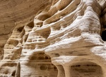
Hike Lick Wash, Grand Staircase-Escalante NM, Utah
Lick Wash is located in Grand Staircase-Escalante National Monument in southern Utah. The creek runs through a wash which in some sections narrows to become a slot canyon. Use Skutumpah Road, also known as BLM 500, to get to Lick Wash.
Price: $208.72