Give us feedback!


 See all

Our philosophy is simple. We want to encourage you to dream. BIG! Then we help you plan your trip, get the most out of it while you're traveling and help you share your experience with friends.
Join Now It's FREE
Dream Packages
Duration: 8 hours
Price: $220.83
Price: $220.83
Duration: 2 days
Price: $242.00
Price: $242.00
Duration: 5 hours
Price: $106.33
Price: $106.33
Duration: 6 days
Price: $606.00
Price: $606.00
Dreams Still To Do
Checked-Off Dreams
Dreams Still To Do
Checked-Off Dreams
Advertisement
Explore Adventure Sports
-
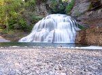
Swim at Lower Falls, Robert H. Treman State Park, Ithaca, New York
Lower Falls in Robert H. Treman State Park, Ithaca, is a popular swimming area accessible from the main entrance. It's a short distance from the park's office, offering both viewing spots and the opportunity to swim in the water. The falls have a shallow area, allowing visitors to walk right up to the base of the falls. -
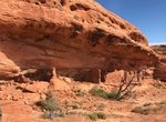
Hike Lower Fish Creek Trail, Comb Wash, Utah
Great hike out to the Anasazi ruins and rock art sites. The upper reaches are best explored from the west, via Hwy 261, the lower section is accessed via the unpaved but good quality Comb Wash Road, running between Hwy 95 and US 163. Some ruins take a little scrambling to reach, and a few sections of the canyon floor have thick undergrowth. -
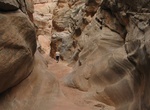
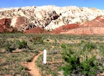
Hike Lower Hackberry Narrows, Grand Staircase-Escalante National Monument
Hackberry Canyon is a moderately difficult hike is one of the more scenic and popular canyon routes in the western half of the Grand Staircase-Escalante National Monument, Utah. Hackberry Canyon is one of the most popular of the Cottonwood Canyon Road hikes, and it is done generally one of two ways. The first is as a dayhike into the lower part of Hackberry Canyon, an... -
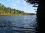
Fish Lower Hadlock Pond, Maine
Lower Hadlock is a scenic water with Norumbega Mountain rising up from the western shore. Access is easily gained over a road off Route 3 (198) several miles north of Northeast Harbor. An adequate boat launching site is available for canoes/small boats. This pond is the water supply for Northeast Harbor, and swimming is not permitted. Stocked brown trout generally pro... -
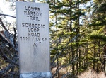
Hike Lower Harbor Trail, Schoodic Peninsula, Acadia National Park, Maine
Lower Harbor Trail is aneasy, 1.5 miles (2.4 km) trail in Schoodic Peninsula, Acadia National Park, Maine. Following the coastline this trail wanders through pine forests, offering the possibility of viewing sea birds. -
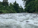
Whitewater Raft Lower Klamath River, California
Just south of the Oregon Border, BLM's Stateline boat ramp and primitive campground is used as a take-out point on the Klamath River for the 17-mile stretch of class I–V whitewater upriver. The first five miles are relatively easy with class II and III rapids for warm up. In Hell's Corner Gorge that follows, the pool-drop rapids are frequent and long, and boater... -
Mountain Bike Lower Loop Trail, Crested Butte, Colorado
Lower Loop Trail is a 7.3 mile loop trail located near Crested Butte, Colorado. Lower Loop connects with a few other trails, providing alternate routes such as Woods Walk and the Budd Trail along the way. -
Cruise Lower Mekong, Vietnam & Cambodia
Cruises down the Lower Mekong River from Siem Reap, Cambodia or up-river from Ho Chi Minh City, Vietnam with focus on important stops in Cambodia and Vietnam are popular with visitors to Southeast Asia. Cruising on the river allows travelers the luxury of exploring the culturally significant sites adjacent to the river’s banks from the comfort of a floating hote... -
Hike Lower Mount Cammerer Trail, Great Smoky Mountains National Park, Tennessee
The Lower Mount Cammerer Trail is a hiking trail in the Great Smoky Mountains National Park of Cocke County, Tennessee. The trail ascends Mount Cammerer (elev. 4,928 ft (1,502 m); 1,502 m), leading (via a connection with the Appalachian Trail) to a small, untraditional firetower at the summit, from which panoramic views of Cocke County, the main range of the Grea... -
Hike Lower Muley Twist Canyon, Capitol Reef National Park
Lower Muley Twist Canyon in Capitol Reef National Park offers many options for side trips and off-trail exploring. The 6 mile (9.7 km) one way hike is in a deep, narrow, twisting canyon with large alcoves. Leave a vehicle at each end. From 1881 to 1884, the canyon served as a wagon route for Mormon pioneers traveling south toward San Juan County. The canyon was though... -
Whitewater Raft Lower Naranjo River, Costa Rica
The Upper Naranjo River is a fast-flowing 50-mile river that forms the southern boundary of Manuel Antonio National Park in Costa Rica. The lower sections of the river are popular with families and tourists, offering easy Class II–III whitewater. -
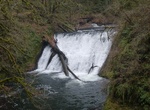
Hike to Lower North Falls, Silver Falls State Park, Oregon
Lower North Falls, is a 30 feet (9.1 m) tall waterfall located in the Silver Falls State Park at the east end of the city of Salem, in Marion County, in the U.S. state of Oregon. It is located in a privileged area on the west foothills where Mount Hood National Forest meets with the Middle Santiam Wilderness. Several prominent waterfalls are located in the Park along ... -
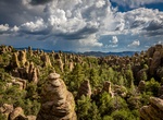
Hike Lower Rhyolite Canyon & Sarah Deming Canyon, Chiricahua National Monument, Arizona
A good way to view the rocks without driving up the road, this mostly-level trail takes you to Rhyolite Canyon, a canyon lined with rock pinnacles. Walk 1.5 miles / 2.4 km until you reach the junction between Upper Rhyolite Canyon and Sarah Deming trails. Return the same way. -
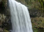
Hike to Lower South Falls, South Falls, Silver Falls State Park, Oregon
Lower South Falls, is a 93 feet (28 m) waterfall located in the Silver Falls State Park at the east end of the city of Salem, in Marion County, in the U.S. state of Oregon. It is located in a privileged area on the west foothills where Mount Hood National Forest meets with the Middle Santiam Wilderness. Several prominent waterfalls are located in the Park along Trail ... -
Hike Lower Spring Canyon, Capitol Reef National Park, Utah
The Lower Spring Canyon in Capitol Reef National Park is a back country route through the park. The canyon is about 7 miles long to where it meets up with Chimney Rock Canyon Trail. Hikers typically start at Chimney Rock Canyon and then get a ride back once they reach the southern end at Route 24. At 9.9 miles end-to-end (including a 3-mile approach), Lower Spring Ca...


Price: $176.03