Give us feedback!


 See all

Our philosophy is simple. We want to encourage you to dream. BIG! Then we help you plan your trip, get the most out of it while you're traveling and help you share your experience with friends.
Join Now It's FREE
Dream Packages
Duration: 8 hours
Price: $83.37
Price: $83.37
Duration: 3 hours
Price: $140.24
Price: $140.24
Duration: 2 days
Price: $242.00
Price: $242.00
Duration: 4 hours 30 minutes
Price: $176.03
Price: $176.03
Dreams Still To Do
Checked-Off Dreams
Dreams Still To Do
Checked-Off Dreams
Advertisement
Explore Adventure Sports
-
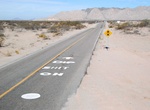
Drive Mexican Federal Highway 5, Baja California, Mexico
Federal Highway 5 is a toll-free part of the federal highways corridors, and follows the northeast length of the state of Baja California from the US-Mexico border in Mexicali to the junction with Fed. 1. The highway is inside the Mexicali Municipality and the San Felipe Municipality. From San Felipe to the south, the road follows the seacoast of the Gulf of Californi... -
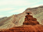
Visit Mexican Hat, Utah
Mexican Hat is a small settlement on the San Juan River in south-central San Juan County, Utah, United States. The name "Mexican Hat" comes from a curiously sombrero-shaped, 60-foot (18 m) wide by 12-foot (3.7 m) thick (18.3 x 3.7 m), rock outcropping on the northeast edge of town. The "Hat" has two rock climbing routes ascending it. It is on U.S. Route 163 just 3 mil... -
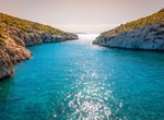
Visit Mġarr ix-Xini, Gozo Island
Mġarr ix-Xini (Maltese:L-Imġarr ix-Xini), is a bay close to Għajnsielem (southwest), Xewkija and Sannat (southeast) on the Maltese island of Gozo. It lies in a gorge to the west of Mġarr Harbour, accessible mainly from the nearest village of Xewkija as well from Sannat. During the rule of the Order, it served as a small harbour for galleys. A small watchtower was buil... -
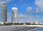
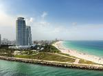
Visit Miami, Florida
Art Deco architecture, mid-century lifeguard stations and wide sandy beaches are all images conjured when contemplating a visit to Miami, Florida. Miami Beach may be one of the most famous oceanfronts in the world and is a must-see, but Miami is much more than beach volleyball and bikinis. The largest collection of Art Deco buildings in the world may be found in Miami... -
Visit Miami's South Beach, Florida
South Beach, also nicknamed SoBe, is a neighborhood in the city of Miami Beach, Florida, located due east of Miami city proper between Biscayne Bay and the Atlantic Ocean. The area encompasses all of the barrier islands of Miami Beach south of Indian Creek. This area was the first section of Miami Beach to be developed, starting in the 1910s, thanks to the development... -
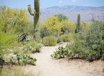
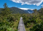
Hike Mica View Loop, Saguaro National Park, Arizona
From the Picnic Area, go north on the Mica View Trail. Look carefully to see many young saguaros under their palo verde “nurse trees”. This is also a good place to look for Gila Woodpeckers and Gilded Flickers and their nest holes in saguaros. At Broadway trailhead turn right on Shantz Trail then a quick right onto the Cactus Forest Trail heading south. Th... -
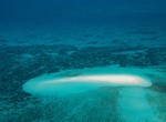
Dive Michaelmas and Upolu Cays National Park, Australia
Michaelmas and Upolu Cays is a national park in Queensland, Australia, 1,409 km (876 mi) northwest of Brisbane and 33 km (21 mi) east of Cairns. It comprises two small cays on Michaelmas Reef, which forms the north-eastern section of the Arlington reef complex, within the Great Barrier Reef. Michaelmas Cay is a protected sanctuary for 27,000 migratory seabirds, and o... -
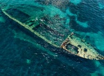
Snorkel or Dive Michelle Shipwreck, Dugi Otok Island, Croatia
The shipwreck Michelle is just north of the island Dugi Otok in Adriatic sea, Croatia. -
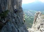
Climb Michielli-Strobel via Ferrata, Italian Dolomites
Climbing the Michielli Strobel via Ferrata at the Pomagagnon mountain group in the Italian Dolomites rewards the mountaineer with well-earned impressive views of the Cortina valley ranging below along with a true sense of accomplishment. The top of Punta Fiames (2,240 meters) on the western most crag of Michielli Strobel is accessed by a via Ferrata (“iron road&... -
Explore Michinmahuida, Pumalín National Park, Chile
Michinmahuida is a glaciated stratovolcano located in Los Lagos Region of Chile. It lies about 15 km east of Chaitén volcano, and was extensively covered in ash during the 2008 eruption of Chaitén. The stratovolcano lies above the regional Liquine-Ofqui Fault zone, and the ice-covered massif towers over the south portion of Pumalín Park. It has a ... -
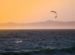
Kiteboard or Windsurf Mid-Basin (Lake Mohave), Nevada
The National Park Service has designated the area at the end of Mid-Basin Road as a Kiteboarding Use Area. Lake Mohave and Lake Mead are known for high winds that come up unexpectedly. Recommended for advanced kiteboarders only. How to Get There: Travel to the end of Mid-Basin Road, south of Cottonwood Cove on Lake Mohave A permit is required to kiteboard on th... -
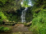
Hike to Middle Black Clough Waterfall, Bleaklow, Glossop, England
Beautiful waterfall with free parking. The hike is hard with walking over slippery rocks in water. Parking on Crossgate Lane by the wall. -
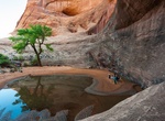
Hike to Middle Earth Waterfall, Moab, Utah
The Middle Earth Waterfall trail is located between the Gold Bar Arch and Corona Arch trails west of Moab, Utah. The trail follows a side drainage of Gold Bar Canyon for about 2 miles where it ends up below a high spillover. Most of the time there won't be any water in the canyon so there won't actually be a waterfall to see. -
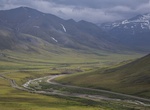
Explore Middle Fork Koyukuk River, Alaska
The Middle Fork Koyukuk River is a 62-mile (100 km) tributary of the Koyukuk River in the U.S. state of Alaska. Formed by the confluence of the Bettles and Dietrich rivers near Wiseman on the southern flank of the Brooks Range, the Middle Fork flows generally southwest to its confluence with the North Fork Koyukuk River, with which it forms the main stem of the Koyuku... -
Raft or Kayak Middle Fork of Salmon River, Idaho
Dropping more than 2,100 meters from its headwaters, the Salmon River’s Middle Fork is nirvana for aficionados of whitewater rafting as the river cuts its way through rocky gorges in high country inhabited by elk, black bear, moose and bighorn sheep. The unparalleled trip covers over 160 kilometers and more than 100 Class III and Class IV rapids in non-stop fash...

Price: $220.83