Give us feedback!


 See all

Our philosophy is simple. We want to encourage you to dream. BIG! Then we help you plan your trip, get the most out of it while you're traveling and help you share your experience with friends.
Join Now It's FREE
Dream Packages
Duration: 3 hours
Price: $173.83
Price: $173.83
Duration: 5 hours
Price: $106.33
Price: $106.33
Duration: 4 hours
Price: $120.43
Price: $120.43
Duration: 8 hours
Price: $83.37
Price: $83.37
Dreams Still To Do
Checked-Off Dreams
Dreams Still To Do
Checked-Off Dreams
Advertisement
Explore Adventure Sports
-
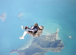
Skydive over Mission Beach (Townsville), Queensland, Australia
Enjoy a spectacular scenic flight over pristine tropical rainforest with views over the famous Great Barrier Reef. Freefall from 14,000 ft at 200km/hr for a full 60 seconds of super-charged excitement before landing on Australia's most scenic drop zone in beautiful Mission Beach. -
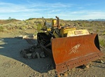
Off-road to Mission Mine, California
The Mission Mine is a great mine to visit when in Joshua Tree's Old Dale Mining District. It's a pretty easy mine to reach with high clearance vehicle. Start the drive at the dirt Old Dale Road turn off from the paved Pinto Basin Road in Joshua Tree National Park. Turn right 12.7 miles down Old Dale Road to take side road to Mission Mine. -
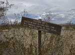
Hike to Mission, Sunrise & Gold Rose Wells, Joshua Tree National Park, California
Old Dale Road and Pinto Basin has three wells, once an important water sources for the mines and the people who traveled the area. Start the drive at the dirt Old Dale Road turn off from the paved Pinto Basin Road in Joshua Tree National Park. Mission Well stopping point is 9.7 miles down Old Dale Road. It's about 2.6 miles out and back hike to all 4 sites. Drive ab... -
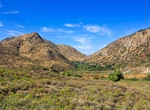
Explore Mission Trails Regional Park, San Diego, California
Mission Trails Regional Park is a 5,800-acre (23 km2) open space preserve within the city of San Diego, California, established in 1974. It is the sixth-largest municipally owned park in the United States, and the largest in California. The park consists mostly of rugged canyons and hills, with both natural and developed recreation areas, including many beautiful flow... -
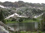
Hike Missouri Lakes Trail, Colorado
Missouri Lakes Trail is is located in the Holy Cross Wilderness in Colorado's the Rocky Mountains, south of Mount of the Holy Cross in Eagle County. The Missouri Lakes trail is 4.4 miles long. It begins at Missouri Creek Road #704 and ends at Cross Creek Trail and Fancy Pass Trail #2006: The first mile of the trail passes diversion dams and water pipelines. Just past... -
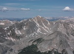
Summit Missouri Mountain, Colorado
Missouri Mountain is a high mountain summit in the Collegiate Peaks of the Sawatch Range of the Rocky Mountains of North America. The 14,074-foot (4,290 m) fourteener is located in the Collegiate Peaks Wilderness of San Isabel National Forest, 15.2 miles (24.5 km) northwest by west (bearing 302°) of the Town of Buena Vista in Chaffee County, Colorado, United State... -
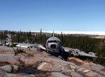
Hike to Miss Piggy C-46 crash Site, Churchill, Manitoba, Canada
Miss Piggy is a Curtiss C-46 freight plane owned by Lamb Air. On a 1979 flight, the plane had engine trouble during its approach to the runway and managed to land among the rocks without a fatality. Be careful the bears. It's amazing that the crew survived landing on these rocks! some pretty intricate artwork now adorns the plane. -
Hike Mist Falls Trail, Kings Canyon National Park, California
This sandy trail follows the glaciated South Fork Canyon through forest and chaparral, past an impressive show of rapids and cascades, to one of the largest waterfalls in Sequoia and Kings Canyon National Parks. The first part of this 8-mile round trip is relatively flat; during the last mile to the falls, the trail gains 600'. The average time for this trip is 4 to ... -
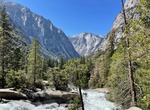
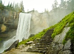
Hike Mist Trail, Yosemite National Park
The Mist Trail is one of the most popular short hikes in Yosemite National Park, California, USA. The hike follows the Merced River, starting at Happy Isles in Yosemite Valley, past Vernal Fall and Emerald Pool, to Nevada Fall. Along the trail, the Merced River is a tumultuous mountain stream, lying in a U-shaped valley. Enormous boulders, some the size of a house, ar... -
Tour Mitchell Caverns, California
The Mitchell's Caverns, within the Mitchell Caverns Natural Preserve, are a trio of limestone caves, located on the east side of the Providence Mountains at an elevation of 4,300 feet (1,300 m), within the Providence Mountains State Recreation Area. They are located in the Mojave Desert, at the north-western end of Essex Road, off of Interstate 40 (Needles Freeway) in... -
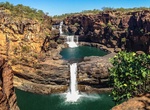
Off-road & Hike to Mitchell Falls (Mitchell River National Park), Western Australia
Mitchell River National Park is a national park in the Kimberley region of Western Australia, 2,140 kilometres (1,330 mi) northeast of Perth. The two main features of the park are Mitchell Falls and Surveyors Pool. The Mitchell Plateau track, off the Kalumburu Road (172 km (107 mi) north of the Gibb River Road junction, is accessible by 4WD only. The park adjoins the ... -
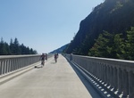
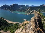
Hike or Bike Mitchell Point Segment of Columbia River Highway State Trail, Hood River, Oregon
The nearly 6-mile segment of the Historic Columbia River Highway State Trail connects Wyeth Trailhead (I-84 near milepost 51) to Viento State Park. The trail offers amazing views of the Gorge and travels around Shellrock Mountain on the 500’ Summit Creek Viaduct — a bridge over land. Some sections are alongside I-84. This section also passes four waterfall... -
Hike Mitchell Point Trail, Hood River, Oregon
The Michell Point Trail takes off from the east end of the parking lot. The Mitchell Point Trail is 2.6 miles up and back with an elevation gain around 1,300 feet. The trail follows a series of switchbacks until a crest with incredible views of the Columbia River and rock formations on the Washington side. -
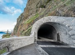
Hike or Bike Mitchell Point Tunnel, Oregon
The Mitchell Point Tunnel is a pedestrian and bike only tunnel opened on March 21, 2025. It was originally a tunnel located towards the eastern end of the Historic Columbia River Highway in Oregon, west of Hood River. The original tunnel existed from 1915 to 1966. Mitchell's Point is named for Captain Mitchell, an early Oregon settler who was said to have jumped from... -
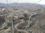
Ride Mi Teleférico, La Paz, Bolivia
Mi Teleférico is an aerial cable car urban transit system opened in 2014 in the Bolivian city of La Paz. Currently three lines are in operation and six more lines are in the planning stage. The three initial lines were built by the Austrian company Doppelmayr. The first two lines, Red and Yellow, connect La Paz with the neighboring city of El Alto. The network ...
Price: $99.36