Give us feedback!


 See all

Our philosophy is simple. We want to encourage you to dream. BIG! Then we help you plan your trip, get the most out of it while you're traveling and help you share your experience with friends.
Join Now It's FREE
Dream Packages
Duration: 3 hours
Price: $140.24
Price: $140.24
Duration: 15 hours
Price: $149.00
Price: $149.00
Duration: 7 hours
Price: $179.00
Price: $179.00
Duration: 4 hours 30 minutes
Price: $176.03
Price: $176.03
Dreams Still To Do
Checked-Off Dreams
Dreams Still To Do
Checked-Off Dreams
Advertisement
Explore Adventure Sports
-
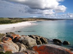
Hike Bay of Fires, Tasmania, Australia
Hike the remote landscape and breathtaking beaches along the East Coast of Tasmania exploring the Bay of Fires. This 16 miles, 4 days walk will be on soft sandy beaches, surreal rock formations and coves. The Bay of Fires walk is a four-day guided trip; you can’t do it solo (there is no water on the route). After a 5.5 mile walk on the first day you will arriv... -
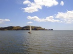
Sail Bay of Islands, New Zealand
Sailing in the Bay of Islands off the east shore of New Zealand’s North Island provides an opportunity to enjoy yachting in sheltered waters with abundant wildlife. Dispersed off shore stretching 80 km, sailors can count more than 80 islands divided by short passages boasting beautiful beaches, convenient anchorage and quaint towns. Blue penguins, dolphin, robin... -
Windsurf or Kitesurf Bay of Puck, Poland
Due to the strong winds and shallow waters Puck Bay in Northernn Poland is considered one of the best places for windusrfing and kitesurfing in Europe. The Bay of Puck or Puck Bay is a shallow western branch of the Bay of Gdańsk in the southern Baltic Sea, off the shores of Gdańsk Pomerania, Poland. It is separated from the open sea by the Hel Peninsula. The bay has a... -
Bike or Hike Bayshore Bikeway (Silver Strand Bikeway), Coronado, California
The Silver Stand is a long stretch of land from Coronado to Imperial Beach. There is a great bike bath along the entire length that is flat and smooth. The bike path starts from the ferry landing or in front of the Coronado Yatch Club and goes around the southern part of San Diego Bay. It's part of the longer 24 mile Bayshore bikeway that loops the bay and involves a ... -
Hike Bayside Trail (Cabrillo National Monument), San Diego, California
There are many short trails with fantastic views throughout Cabrillo National Monument (e.g. tidepool area, around the bunkers, whale lookout, and lighthouse) including the Bayside Trail. This trail is 2.5 miles (round-trip) with great views of the ocean, Ballast Point (where Cabrillo landed), downtown, Coronado Island, Tijuana, sandstone cliffs, ships, plant life, an... -
Visit Bazaruto Archipelago, Mozambique
The Bazaruto Archipelago is a group of six islands in Mozambique, near the mainland city of Vilankulo. It comprises the islands of Bazaruto, Benguerra, Magaruque, Banque, Santa Carolina (also known as Paradise Island) and Shell. The group belongs to Vilankulo District of Inhambane Province. The islands were formed from sand deposited by the Save River, which has since... -
Ride Beach Cruiser Bike on a Beach
Cruise down the beach on a Beach Cruiser. Enjoy the sand, surf and ocean breezes. -
Hike Beacons Way, Brecon Beacons National Park, Wales
The Beacons Way is a waymarked long distance footpath in the Brecon Beacons National Park, Wales. It is a linear route which runs for 95 miles (153 km) east to west through the National Park, and passes many of the most important landmarks and mountain peaks in the mountain range. It also includes many of the towns in the park as well as popular attractions such as Ca... -
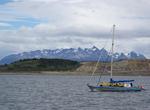
Sail Beagle Channel, Argentina & Chile
Beagle Channel is a strait in the archipelago island chain of Tierra del Fuego on the extreme southern tip of South America partly in Chile and partly in Argentina. The channel separates the larger main island of Isla Grande de Tierra del Fuego from various smaller islands including the islands of Picton, Lennox and Nueva; Navarino; Hoste; Londonderry; and Stewart. Th... -
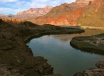
Hike Beamer Trail, Grand Canyon National Park, Arizona
The Beamer Trail is a backpacking trail located on the South Rim of the Grand Canyon National Park. The trail begins at the end of the Tanner Trail, at the confluence of Tanner Creek and the Colorado River. This confluence created the Unkar Creek Rapids. From here the trail follows the Colorado north (upstream) to its confluence with the Little Colorado River. Th... -
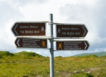
Hike Beara Way, Ireland
The Beara Way is a long-distance trail in Republic of Ireland. It is a 206-kilometre (128-mile) long circular trail around the Beara Peninsula that begins and ends in Glengarriff, County Cork. It is typically completed in nine days. It is designated as a National Waymarked Trail by the National Trails Office of the Irish Sports Council and is managed by the Beara Tour... -
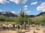
Hike Bear Canyon Trail to Seven Falls, Arizona
Bear Canyon, located in the Sabino Canyon recreation area of the Coronado National Forest near Tucson, Arizona, offers views of the Santa Catalina Mountains to the north. Accessible by tram or foot from the Sabino Canyon visitors' center, Bear Canyon contains such attractions as the seasonal Seven Falls and Thimble Peak. -
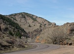
Drive Bear Creek Canyon Scenic Mountain Drive, Colorado
Bear Creek Canyon Drive, a linear district, includes two miles of scenic road, which is now part of State Highway 74. The drive is between the town of Morrison and the town of Idledale. The scenic drive connects to the west border of the Red Rocks Mountain Park District. The Denver Mountain Parks owns a 200 feet (61 m) strip of canyon on both sides of Bear Creek. The ... -
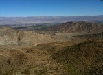
Hike Bear Creek Canyon Trail, La Quinta, California
The Bear Creek Canyon Trail is a strenuous if going all the way to the oasis at the end of the trail. The trail is 9 miles and 1,873 feet elevation gain. At the 4 mile mark there is a large oasis tucked into the end of the canyon. The trailhead is near the end of Eisenhower Drive in La Quinta. The trail also continues along the west wide of the city to where it merges... -
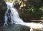
Hike to Bear Creek Falls, Payette National Forest, Idaho
Bear Creek is a tributary of Wildhorse River, which is a tributary of the Snake River. Access to the Falls is cross-country on extremely steep slopes. Rattlesnakes are a problem.


Price: $120.43