Give us feedback!


 See all

Our philosophy is simple. We want to encourage you to dream. BIG! Then we help you plan your trip, get the most out of it while you're traveling and help you share your experience with friends.
Join Now It's FREE
Dream Packages
Duration: 4 hours 30 minutes
Price: $176.03
Price: $176.03
Duration: 6 days
Price: $606.00
Price: $606.00
Duration: 7 hours
Price: $144.00
Price: $144.00
Duration: 15 hours
Price: $149.00
Price: $149.00
Dreams Still To Do
Checked-Off Dreams
Dreams Still To Do
Checked-Off Dreams
Advertisement
Explore Adventure Sports
-
Hike Mule Creek Trail, Oregon
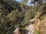
The Mule Creek Trail #1159, located on the Bureau of Land Management portion of the wilderness, provides a steep route on an out mining trail between the river and Panther Ridge. In general cross-country travel is not advised due to steep slopes and heavy vegetation. The Forest Service administers the entire wilderness, including the Bureau of Land Management portion,... -
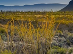
Hike Mule Ears Spring Trail, Big Bend National Park, Texas
This hike leads through the foothills of the Chisos Mountains, skirts Trap Mountain, and crosses several arroyos. Near the spring is an old rock corral. The spring itself is overgrown with shrubs, but ferns and cattails also grow there. Remember, no contaminating/bathing in backcountry springs. Mule Ears Overlook parking area, mile 15, Ross Maxwell Scenic Drive. -
Hike or Ride Mule Hill Trail, Escondido, California
Mule Hill Trail is a 10.25 miles (one-way) trail located near Escondido, California. The first 4.5 miles is generally flat fire road. The next 2 miles are hilly single track going up/down Raptor Ridge. The last part is flat trail along Bandy Canyon Road and Ysabel Creek Rd - ending at Hwy 78 and San Pasqual Battlefield State Historic Park. It's one of the newer sectio... -
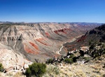
Off-road to Mule Point, Grand Canyon-Parashant National Monument, Arizona
Mule Point Road is access from BLM 1063 in Arizona. Mule Point overlooks colorful Parashant Canyon. The red layer is the Hermit Formation. If you continue south on BLM 1063 it descends the steep Trail Canyon dugway, the road follows the canyon floor toward the Grand Canyon. -
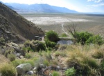
Off-road to Mule Spring, Ownes Valley, California
Mule Spring is a spring(s) and is located in Inyo County, California, United States. The elevation above sea level is 1254 metres. There is a man-made pond at the spring. -
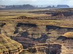
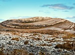
Drive to Muley Point, Utah
Muley Point is a remote, scenic overlook in southern Utah near Mexican Hat. The view provides panoramic vistas of the desert landscape of southern Utah and northern Arizona. Monument Valley is visible in the distance while the San Juan River cuts into the canyon below. It's really worth the effort to get here! This is a peaceful isolated place that has few visitors, ... -
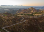
Drive Mulholland Highway, Los Angeles County, California
Mulholland Highway is a scenic road in Los Angeles County, California, that runs approximately 50 miles through the western Santa Monica Mountains from near US Route 101 (Ventura Freeway) in Calabasas to Highway 1 (Pacific Coast Highway) near Malibu at Leo Carrillo State Park and the Pacific Ocean coast - at the border of Los Angeles and Ventura Counties. Mulholland H... -
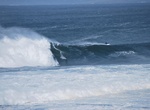
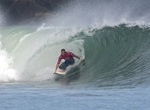
Surf Mullaghmore Head, Ireland
Mullaghmore is one of the best big wave surfing locations in the world. On 8 March 2012, surfers and windsurfers from all over the world rode waves up to 15 metres (49 ft) high off Mullaghmore Head. These waves were about five metres less than the tallest wave ever recorded in Ireland in County Donegal on 13 December 2011, which was 20.4 metres (67 ft) high. The waves... -
Hike Mullaghmore (Peak of Burren), County Clare
Mullaghmore ('Great Summit') is a 180 metre (590') limestone hill in the Burren in Glenquin, Kilnaboy County Clare, Ireland. It is part of a hiking trail called the Mullaghmore Loop in the Burren National Park. -
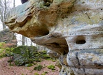
Hike Mullerthal Trail, Luxembourg
The Mullerthal Trail is a 112-kilometer (70-mile) hiking track in the Mullerthal Region of Luxembourg’s Little Switzerland. The trail consists of three loop trails that connect in two places, thus creating a trail shaped like a double 8. Route 1 and Route 2 connect in Echternach, while Route 2 and Route 3 connect in the village of Müllerthal. The three r... -
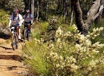
Mountain Bike Munda Biddi Trail, Western Australia
The Munda Biddi Trail a world-class off-road cycling trail in Western Australia, running for over 1000km from Mundaring to Albany - the longest track of its kind in the world. The name ‘Munda Biddi’ means path through the forest in the Noongar Aboriginal language and there are few places left in the world where a 1000km track could be built through an unde... -
Surf Mundaka, Basque Country, Spain
Mundaka (Spanish:Mundaca) is a town and municipality located in the province of Biscay, in the autonomous community of Basque Country, northern Spain. On the coast, Mundaka is internationally renowned one of the best lefts of the world. Mundaka's fantastically shaped rivermouth sandbar creates solid, 200-yard-long, top-to-bottom barrels. Huge swells roll in from the ... -
Hike Munds Wagon Trail, Sedona, Arizona
The Munds Mountain Trail is a challenging, remote trail in the Munds Mountain Wilderness. The trail begins near Committee Tank in a remote area at 6,400' elevation where Schnebly Hill, Jacks Canyon and Hot Loop trails meet above Bear Wallow Canyon. The trail starts with a steep, switchback ascent, climbing 500 feet in a little over a half-mile. There are fine views ov... -
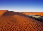
Explore Munga-Thirri National Park (Simpson Desert), South Australia, Australia
Munga-Thirri—Simpson Desert Conservation Park (formerly Simpson Desert Conservation Park and Simpson Desert National Park) is a protected area located in the Australian state of South Australia about 970 kilometres (600 mi) north of the state capital of Adelaide and above 215 kilometres (134 mi) north-east of the town of Oodnadatta. The conservation park occupie... -
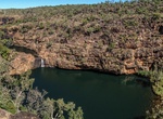
Off-road Munja Track to Bachsten Camp, Western Australia
The Munja Track begins at Mt Elizabeth Station and heads northeast out into the bush and through to Bachsten Camp and on to Walcott Inlet. Mount Elizabeth Station is a pastoral lease that operates as a cattle station in Western Australia. It is situated about 205 kilometres (127 mi) north of Fitzroy Crossing and approximately 340 kilometres (211 mi) east of Derby i...

Price: $83.37