Give us feedback!


 See all

Our philosophy is simple. We want to encourage you to dream. BIG! Then we help you plan your trip, get the most out of it while you're traveling and help you share your experience with friends.
Join Now It's FREE
Dream Packages
Duration: 4 hours 30 minutes
Price: $176.03
Price: $176.03
Duration: 4 hours
Price: $120.43
Price: $120.43
Duration: 3 hours
Price: $180.00
Price: $180.00
Duration: 8 hours
Price: $208.72
Price: $208.72
Dreams Still To Do
Checked-Off Dreams
Dreams Still To Do
Checked-Off Dreams
Advertisement
Explore Adventure Sports
-
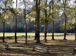
Kayak Narragansett Bay, Rhode Island
Narragansett Bay is a bay and estuary on the north side of Rhode Island Sound and is consideredRhode Island's greatest natural resource.. The bay has 250 mile of coastline and 15 islands, the three largest ones are Aquidneck Island, Conanicut Island, and Prudence Island. For more than 50 years, 12-meter yachts competed on the bay for sailing's prestigious America's C... -
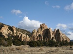
Hike Narrows Earth Trail, Borrego Springs, California
The Narrows Earth Trailhead is just off Route 78 next to “Powder Dump Wash”. The concrete and boulder near trailhead was built by the road crews back in the 1930’s. The crews named this area “Powder Dump Wash”. It was part of a storage house where they kept explosives. Along the trail you may have seen darker colored rocks. The... -
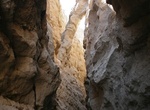
Hike Narrows in Blue John Canyon, Utah
The narrows of Blue John Canyon are some of the best anywhere in the Southwest. Blue John Canyon is a slot canyon in eastern Wayne County, Utah, southwest of the Horseshoe Canyon Unit of Canyonlands National Park and 42 miles south of Green River. It is a tributary of Horseshoe Canyon, running northeastwards from the Robbers Roost Flats. The canyon is deep with branc... -
Attend the Narrows of the Green Race, North Carolina
The Narrows of the Green is a 2.9-mile (4.7 km) section of the Green River, in Henderson County and Polk County, between the Big Hungry creek confluence and the Fishtop access area, in western North Carolina, United States. It is roughly 35 miles (56 km) south of downtown Asheville. The Green Narrows is best known for being one of the most extreme kayaking runs in the... -
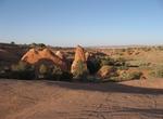
Hike Narrows Rim Trail, El Malpais National Conservation Area, New Mexico
Within the El Malpais National Conservation Area lies the Narrows. It is named for the 3-mile narrow corridor that developed when lava flowed close to the base of a 500-foot sandstone mesa. Most of the lava observed is from McCarty’s crater, and at approximately 1500 years old, it is the youngest flow in the area. The trailhead and parking area for the Narrows ... -
Stroll Narva Promenade, Narva, Estonia
Narva Promenade is a beautiful riverside walkway. You can admire nature and Russia on the other side of the river. -
Visit NASCAR Hall of Fame, Charlotte, North Carolina
The NASCAR Hall of Fame honors drivers who have shown exceptional skill at NASCAR driving, all-time great crew chiefs and owners, and other major contributors to competition within the sanctioning body. NASCAR committed itself to building a Hall of Fame and on March 6, 2006, the city of Charlotte, North Carolina, was selected as the location. Ground was broken for the... -
Attend NASCAR Race at Charlotte Motor Speedway, Concord, North Carolina
Charlotte Motor Speedway is a motorsports complex located in Concord, North Carolina, United States 13 miles from Charlotte, North Carolina. The complex features a 1.5 miles (2.4 km) quad oval track that hosts NASCAR racing including the prestigious Coca-Cola 600 on Memorial Day weekend and the Sprint All-Star Race. The speedway was built in 1959 by Bruton Smith and i... -
Drive NASCAR Stockcar
Fans of NASCAR auto racing can drive the same style of automobiles that their heroes pilot around race tracks on any given weekend. Typically operated in the form of a racing school where future stock car racers come to learn their craft and one time racers spend a few days soaking up the experience, the ability to drive the highly refined automobiles and interact wit... -
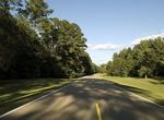
Drive Natchez Trace Parkway, Mississippi, Alabama & Tennessee
The Natchez Trace Parkway is a National Park Service unit in the southeastern United States that commemorates the historic Old Natchez Trace and preserves sections of the original trail. Its central feature is a two-lane parkway road that extends 444 miles (715 km) from Natchez, Mississippi to Nashville, Tennessee. Access to the parkway is limited, with more than 50 a... -
Drive across Natchez Trace Parkway Bridge, Tennessee
The Natchez Trace Parkway Bridge is a concrete double arch bridge located in Williamson County, Tennessee, 14 km (8.7 mi) from the northern terminus of the Natchez Trace Parkway. It is 479.1 m (1,572 ft) long and carries the two-lane Natchez Trace Parkway 44.2 m (145 ft) over State Route 96 and a heavily wooded valley. The 177.4 m (582 ft) long main span is symmetrica... -
Hike Natchez Trace Trail, Tennessee, Alabama & Mississippi
The Natchez Trace Trail is a designated National Scenic Trail in the United States whose route generally follows sections of the 444-mile (715 km) Natchez Trace Parkway through the states of Tennessee, Alabama, and Mississippi. Unlike other national scenic trails, however, the trail is not envisioned as a long, continuous footpath, as is the case with other national s... -
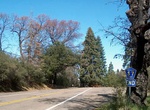
Drive Nate Harrison Grade (S7), Palomar Mountain, San Diego, California
County Route S7 is a county route in San Diego County, California that provides access to Palomar Mountain. For better views, head down instead of up the grade. S7's western terminus is at State Route 76 east of Pauma Valley, California. It begins as a dirt road known as the Nate Harrison Grade. Then it returns to pavement as it ascends Palomar Mountain and meets San ... -
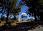
Visit National Astronomical Observatory, Baja California, Mexico
Mexico's National Astronomical Observatory (El Observatorio Astronómico Nacional - OAN) is located in Sierra San Pedro Mártir in Baja California. The current site has been found to have excellent astronomical seeing. There are three optical telescopes on the summit of Sierra San Pedro Mártir, all with a Ritchey-Chrétien design: The 2.12 m ... -
Hike National Blue Trail, Hungary
The National Blue Trail is a national trail in Hungary incorporated into the European Long Distance Walking Route E4. The route starts atop the Irottkő Mountain (884 m) on the Austrian-Hungarian border then cuts across Hungary eventually ending 1,128 km later at the village of Hollóháza by the Hungarian-Slovakian border. (Interactive map). The name of th...


Price: $606.00