Give us feedback!


 See all

Our philosophy is simple. We want to encourage you to dream. BIG! Then we help you plan your trip, get the most out of it while you're traveling and help you share your experience with friends.
Join Now It's FREE
Dream Packages
Duration: 3 hours
Price: $173.83
Price: $173.83
Duration: 3 hours 30 minutes
Price: $99.36
Price: $99.36
Duration: 4 hours
Price: $120.43
Price: $120.43
Duration: 4 hours 30 minutes
Price: $176.03
Price: $176.03
Dreams Still To Do
Checked-Off Dreams
Dreams Still To Do
Checked-Off Dreams
Advertisement
Explore Adventure Sports
-
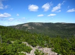
Hike Norumbega Mountain and Hadlock Ponds Loop Trail, Acadia National Park, Maine
Norumbega Mountain and Hadlock Ponds Loop Trail is a 3.2 mile loop trail located west of Route 3 (198) in Acadia National Park, Maine. Dogs are also able to use this trail but must be kept on leash. But pets are nt recommended for Norembega Goat Trail. -
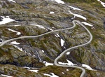
Drive Norwegian County Road 63 to Geirangerfjord, Norway
Norwegian County Road 63 (Norwegian:Fylkesvei 63orFv63) is a Norwegian county road in Møre og Romsdal county and a very small part in Oppland county, Norway. It begins at Norwegian National Road 15 along the lake Langvatnet in Skjåk Municipality in Oppland county and it heads north where it ends at the junction with the European route E136 highway near th... -
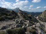
Hike Nosal Mountain, Tatra National Park, Poland
Nosal Mountain is a mountain in the Tatra Mountains of Poland, and is 1,206 metres AMSL at its highest. It is a popular tourist destination located near the Polish town of Zakopane, particularly for skiing and gliding. -
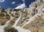
Hike Notch Trail, Badlands National Park, South Dakota
Notch Trail is a moderate to strenuous trail in Badlands National Park. After meandering through a canyon, this trail climbs a log ladder and follows a ledge to "the Notch" for a dramatic view of the White River Valley. Trail begins at the south end of the Door and Window parking area. Watch for drop-offs. Not recommended for anyone with a fear of heights. The first ... -
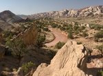
Drive Notom-Bullfrog Road, Capitol Reef National Park, Utah
The Notom-Bullfrog road intersects Utah Hwy 24 9 miles (14.4 km) east of the Capitol Reef Visitor Center and extends south to Bullfrog Marina and Glen Canyon National Recreation Area. This road is paved for the first 10 miles (16.1 km), and then becomes a well maintained dirt road. The road runs along the eastern side of the Waterpocket Fold and offers excellent scene... -
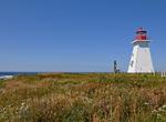
Drive Nova Scotia Lighthouse Route, Canada
The Lighthouse Route is a scenic roadway in the Canadian province of Nova Scotia that follows the province's South Shore for 339 km (211 mi) from Halifax to Yarmouth. More than 20 lighthouses can be found on this winding road along the shore. Begin your trip in Halifax and make your first stop at Peggy's Cove and walk to the lighthouse, one of the most photographed i... -
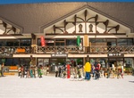
Ski Nozawa Onsen Snow Resort, Japan
Nozawa Onsen Snow Resort is a skiing venue located in Nozawaonsen, Nagano, Japan. Nozawa Onsen Village is located at the foot of the ski resort, which spans across three main areas. The resort is a large ski area that opened over seventy years ago. Covering 297 hectares (730 acres), the southern part of the resort was used for biathlon competitions at the 1998 Winter ... -
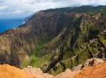
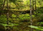
Hike Nu'alolo Trail, Kauai, Hawaii
Ancient Hawaiian trails connect the ridges above Nualolo and Awaawapuhi Valleys in Kokee State Park. The 3.75 mi (6.04 km) trail goes through koa/ʻōhiʻa montane mesic forests and an ʻaʻaliʻi (Dodonaea viscosa) lowland dry shrubland with a great view of Nuʻalolo Valley. Return climb of 1,570 ft (480 m). -
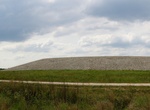
Hike Nuclear Waste Adventure Trail & Museum, Weldon Spring, Missouri
At the Nuclear Waste Adventure Trail go hiking over the encapsulated remnants of the largest explosives factory in America, as well as a Cold War-era uranium refinery. The 54-acre expanse of 1.48 million cubic yards of covered-up PCBs, mercury, asbestos, TNT, radioactive uranium, and radium. -
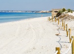
Visit a Nude Beach
A nude beach, sometimes called a clothing-optional or free beach, is a beach where users are at liberty to be nude. Nude beaches usually have mixed bathing. Such beaches are usually on public lands, and any member of the public is allowed to use the facilities without membership in any movement or subscription to any personal belief. The use of the beach facilities is... -
Hike Nugget Creek Trail, Mendenhall Glacier, Alaska
Nugget Creek Trail is a moderate trail that follows the Nugget Creek drainage. Start on the East Glacier Loop and take the Nugget Creek Trail at east end of Nugget Creek. Distance is 3 miles (East Glacier Loop) + 3.5 miles (Nugget Creek Trail). Offers birding, berry-picking, 200-400 years forest growth and information about hydroelectricity and mining. -
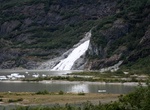
Hike Nugget Falls Trail, Alaska
The Nugget Falls Trail is 0.8 miles long. It begins half way down Photo Point Trail and ends at Nugget Falls, skirting the flats at the edge of Mendenhall Lake. It is a low gradient trail that was completed in 2010. The new construction realigned the trail so the tread is above high water on the lake. The trail follows the shore line of Mendenhall Lake. Views of the ... -
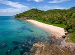
Chill at Nui Bay Beach, Ko Lanta, Thailand
Nui Beach is on the southern part of Ko Lanta Island. It's away from town, its waters are clean and sand soft. There are some bars and restaurants to eat in the break from sunbathing too. -
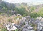
Hike Nui Voi (Elephant Mountain), Hai Phong, Viet Nam
Elephant Mountain is a complex of rocky mountains, alternating, undulating, meandering mountains with geographical location l06 ° 34'7 "Kinh Dong 20 ° 50'30" Vi Do Bac, about Hai Phong city about 20 km, shaped like an elephant lying down. Elephant mountain populations belong to Truong Thanh, An Tien and An Thang communes of An Lao district; is one of the histo... -
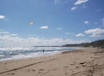
Visit Nukoli'i Beach Park, Kauai, Hawaii
Nukoli'i Beach Park has 2 miles of white-sand shoreline, the longest beach on Kauai's east shore. It has good snorkeling, scuba diving and fishing when the ocean is calm. Not the best for swiming due to surf and currents and shallow rockly bottom.
Price: $242.00