Give us feedback!


 See all

Our philosophy is simple. We want to encourage you to dream. BIG! Then we help you plan your trip, get the most out of it while you're traveling and help you share your experience with friends.
Join Now It's FREE
Dream Packages
Duration: 7 hours
Price: $179.00
Price: $179.00
Duration: 7 hours
Price: $144.00
Price: $144.00
Duration: 8 hours
Price: $83.37
Price: $83.37
Duration: 4 hours 30 minutes
Price: $176.03
Price: $176.03
Dreams Still To Do
Checked-Off Dreams
Dreams Still To Do
Checked-Off Dreams
Advertisement
Explore Adventure Sports
-
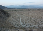
Drive Panlong Road, China
Panlong Road, a 75-km-long winding road with 600 hairpin turns, is located in NW China's Xinjiang Uyghur Autonomous Region. Tucked away in the Pamir Plateau, in the Kunlun Mountains, the winding road is also known as Pamir Plateau Sky road, Pamir´s sky road and Wacha road. At its highest point, the road is 4.269m (14,005ft) above the sea level, at the summit of ... -
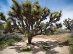
Hike Panorama Loop Trail, Joshua Tree National Park, California
Panorama Loop Trail is located off the Black Rock Canyon Trail in Joshua Tree National Park, California. Hike up a sandy wash, then follow the ridgeline of the Little San Bernardino Mountains. Enjoy scenic views, dense Joshua tree forest, and pinyon-juniper woodland. Leave from the Black Rock Campground backcountry registration board and hike south on Black Rock Canyo... -
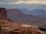
Camp at Panorama Point Campsite, The Maze, Canyonland National Park, Utah
Panorama Point has one campsite in The Maze, Canyonland National Park, Utah. It's 12 miles (2 hrs) from Hans Flat Ranger Station. -
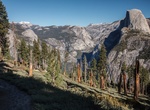
Hike Panorama Trail, Yosemite National Park
The Panorama Trail in Yosemite National Park is 8.5 miles (13.5 km) one way. It provides a close-up view of Illilouette Fall and panoramic views of eastern Yosemite Valley before joining the Mist or John Muir Trails down past Vernal and Nevada Falls. -
Hike Panorama Trail, Kodachrome Basin State Park, Utah
Panorama Trail is a 2.9-mile loop trail in Kodachrome Basin State Park, Utah. It's the longest and most varied of the six hiking routes in the park. -
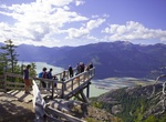
Hike Panorama Trail, Squamish, British Columbia, Canada
This 1.3 km loop trail takes you through coastal forest, Alaskan blueberry bushes, and granite outcroppings. Viewpoints with handcrafted cedar benches dot the trail for rests with a view. The Panorama Trail has an easy elevation grade of approximately 8-10%, allowing people of all ages and fitness levels to complete it in under an hour. Halfway through the trail is th... -
Hike to Panoramic Overlook, Anza-Borrego Desert State Park, California
Panoramic Overlook is a short hike south from Borrego Palm Canyon Campground in Anza-Borrego Desert State Park. -
Drive Panoramic Route, Mpumalanga, South Africa
Panorama Route is best known for its cultural heritage and its dramatic landscapes. Some of the site along the route are Blyde River Canyon, Bourke's Luck Potholes, Echo Caves and God's Window. Hazyview is a town in South Africa's Mpumalanga province which is ideally situated just a few kilometres outside the Kruger National Park. Sabie is a forestry town situated o... -
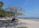
Relax at Pantai Bama Beach, Java, Indonesia
Pantai Bama Beach is surrounded by mangrove forest. It’s a favourite retreat place of local population. You might notice some long-tailed macaques trying to steal any food you might carry, if that happens scare them away with simply lifting a stick as though you were trying to throw it at them. -
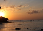
Visit Pantai Padang Taplau, Padang, Indonesia
Pantai Padang Taplau is the beach where you can admire the blue and turquoise colors of water coming over the white sand. It's a very nice place for a morning jog as well as to watch the sunrise. -
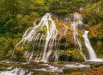
Hike to Panther Creek Falls, Washington
Panther Creek Falls is a 130-foot (40 m) waterfall on Panther Creek in the Wind River Valley in Skamania County, Washington. The waterfall consists of two drops, with the largest at a height of 102 feet (31 m). The waterfall is perennial. The waterfall and the creek which leads up to it are accessible by a trail maintained by the Forest Service. In addition to the mai... -
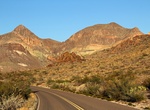
Bike Panther Junction to Castolon via the Ross Maxwell Scenic Drive, Big Bend National Park
This ride travels through some of the most scenic terrain in the park. It skirts the Chisos Mountains and passes interesting geologic features and historic sites. Although the loss of elevation between Panther Junction and Castolon is 1,580ft., the terrain is challenging with many steep hills. -
Bike Panther Junction to Rio Grande Village, Big Bend National Park
Although there are some hills the ride is mostly downhill as the elevation drops 1,900ft. over the course of the ride. Be wary of large motorhomes and trailers travelling this road, especially during fall, winter and spring. For a variation, ride to the Hot Springs Historic District on the 2-mile unpaved spur road 16 miles from Panther Junction. Your shuttle can meet ... -
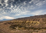
Bike Panther Junction to Rio Grande Village via the Glenn Springs Road, Big Bend National Park
Ride six miles toward Rio Grande Village on the paved road, then turn onto Glenn Springs Road. Follow it for 15 miles as it skirts the Chisos Mountains and leads to a desert spring before joining the River Road. Turn left and follow the River Road for 9.6 miles to its junction with the paved road. Turn right and ride on the paved road for 4 miles to Rio Grande Village... -
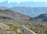
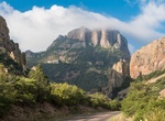
Ride Panther Junction to the Chisos Basin, Big Bend National Park
Ride three miles of gradual uphill west of Panther Junction to the Chisos Basin Junction. Turn left and ride seven miles to the Chisos Basin. The road is very steep, with 15% grades. The elevation gain is 1,650ft. Watch for traffic and be ready to pull off the road if necessary. This ride is an aerobic challenge even for those in excellent physical condition. The ride...


Price: $180.00