Give us feedback!


 See all

Our philosophy is simple. We want to encourage you to dream. BIG! Then we help you plan your trip, get the most out of it while you're traveling and help you share your experience with friends.
Join Now It's FREE
Dream Packages
Duration: 9 hours
Price: $109.14
Price: $109.14
Duration: 6 days
Price: $606.00
Price: $606.00
Duration: 8 hours
Price: $83.37
Price: $83.37
Duration: 15 hours
Price: $149.00
Price: $149.00
Dreams Still To Do
Checked-Off Dreams
Dreams Still To Do
Checked-Off Dreams
Advertisement
Explore Adventure Sports
-
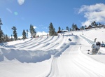
Go Dark Tubing at Big Bear Snow Play, Big Bear Lake, California
Recreation center in Big Bear Lake, California -
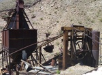
Off-road & Hike Big Bell Mine, Death Valley National Park, California
Big Bell Mine, Death Valley can be reach by 4WD road for about 13 miles to the top of the cable road (5,000 feet elevation) above the mine. Hike down to the mine at 3,600 feet. The drive passes the Chloride City ghost town. The Big Bell mine lay idle from 1912 to 1935, when the Coen Company acquired mining rights to the property. After a preliminary testing period, t... -
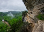
Hike Big Bluff Goat Trail, Buffalo National River, Arkansas
The Goat Trail runs along the 550 feet tall Big Bluff ridge with a section on 5 feet wide. Use the Centerpoint Trail to get to the Goat Trail, where you’ll crawl through a natural tunnel (an “eye” in the rock) before continuing onto the cliffy bit, which soars 350 feet above a perfect U-bend in the Buffalo. -
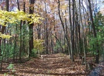
Hike Big Buck Trail, Grandview, West Virginia
This easy 0.9 mile trail loops through a rolling section of forest. Tree identification signs along the way celebrate the great diversity of flora found in the Appalachian forest. The trail begins and ends near Grandview Shelter #2 -
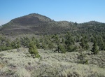
Summit Big Cinder Butte, Craters of the Moon National Monument, Idaho
At 6,515 feet (1,986 m) the highest cinder cone in Craters of the Moon National Monument is Big Cinder Butte which stands more than 700 feet above the surrounding plain. -
Explore Big Cottonwood Canyon, Utah
Big Cottonwood Canyon is a canyon in the Wasatch Range 12 miles (19 km) southeast of Salt Lake City in the U.S. state of Utah. The 15-mile (24 km)-long canyon provides hiking, biking, picnicking, rock-climbing, camping and fishing in the summer. Its two ski resorts, Brighton and Solitude, are popular among skiers and snowboarders. The canyon is accessed by The Big Cot... -
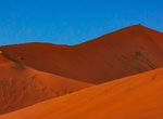
Climb Big Daddy Dune, Namib-Naukluft National Park, Namibia
Big Daddy is the highest dune in the Sossusvlei area, at about 325 meters. Big Daddy is located past Sossusvlei proper, near Deadvlei. It faces another very high dune known as "Big Mama". Big Daddy is distinct from Dune 7 in Namibia, near Walvis Bay. -
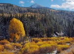
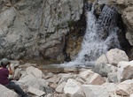
Hike to Big Falls, Forest Falls, San Bernardino National Forest, California
Big Falls trail is a short easy hike to a 5-tiered waterfall located in a beautiful mountain canyon filled with giant redwood trees. The trailhead is reached by turning east off Highway 38 to Valley of the Falls Road in Forest Falls. Continue through the community to the top end of the road. Big Falls trailhead will be the first main parking lot on the left, immedia... -
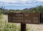
Hike Bigfoot Trail, Joshua Tree National Park, California
Bigfoot Trail a route that connects Quail Springs Trail to Eureka Peak in Joshua Tree National Park. -
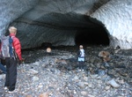
Visit Big Four Ice Caves, Washington
Big Four Mountain is a mountain in the Cascade Range of Washington, located 21 miles (34 km) east of Granite Falls. The mountain is about 6,180 ft (1,880 m) high. At the bottom of its steep, 4,200 ft (1,300 m) high north face, debris piles form from avalanches and are able to remain there year round because of the continuous shade provided by the mountain. At an eleva... -
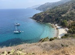
Visit Big Geiger Cove, Catalina Island, California
Big Geiger Cove is west of Little Geiger Cove on Catalina Island. Although there are no morrings, it is one of the best natural anchorages on the island. Located 1.5 miles west of Bird Rock at Isthmus Cove on the north side of Santa Catalina Island and 0.5M SW of Eagle Reef Red Buoy "2". Moorings: None Anchorages: 10 Blue Water Cruising Club leases the on-shore faci... -
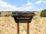
Hike Big Hole Wash, Utah
Big Hole Wash is located in the northeast corner of the San Rafael Swell between Green River and Price, Utah. The lower end of the wash begins off of the Cottonwood Wash Road where it extends upstream for just over 2 miles and dead ends at a big spillover. There is a petroglyph panel can be found along the wash at the 1 mile point from the trailhead. -
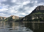
Fish Bighorn Canyon, Bighorn Canyon National Recreation Area, Wyoming & Montana
Whether you choose to fish from a boat or the shoreline, the waters of Bighorn Lake and the Bighorn River truly offer an incredible opportunity to catch numerous species of fish while being surrounded by some of the most beautiful outdoor scenery in the northwest United States. Bighorn Lake - Walleye, brown and rainbow trout, yellow perch, carp, catfish, ling and cra... -
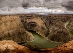
Explore Bighorn Canyon National Recreation Area, Wyoming & Montana
A landscape of sheer cliffs towering 1,000 feet above a ribbon of blue water. World class fishing and a place where wild horses still run free. Bighorn Canyon is a place where imagination meets reality. Bighorn Canyon has unrivaled recreation possibilities. Bighorn Canyon National Recreation Area was established by an act of Congress on October 15, 1966, following the... -
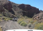
Off-road or Mountain Bike Bighorn Cove Road, Arizona
Bighorn Cove Road begins just south of Willow Beach and ends at Bighorn Cove on Lake Mohave. The road is a dirt road and can get pretty rocky in spots, but can be done with 2WD if you’re careful. Bikers, just look out for large or sharp rocks and for high-sitting vehicles. Access: From Willow Beach, take Jumbo Washington Road south for 1.7 miles. Turn right ...
Price: $176.03