Give us feedback!


 See all

Our philosophy is simple. We want to encourage you to dream. BIG! Then we help you plan your trip, get the most out of it while you're traveling and help you share your experience with friends.
Join Now It's FREE
Dream Packages
Duration: 3 hours
Price: $140.24
Price: $140.24
Duration: 8 hours
Price: $220.83
Price: $220.83
Duration: 2 days
Price: $242.00
Price: $242.00
Duration: 3 hours
Price: $180.00
Price: $180.00
Dreams Still To Do
Checked-Off Dreams
Dreams Still To Do
Checked-Off Dreams
Advertisement
Explore Adventure Sports
-
Hike around Rangitoto Island, New Zealand
Rangitoto Island is a volcanic island in the Hauraki Gulf near Auckland, New Zealand. The 5.5 km wide island is an iconic and widely visible landmark of Auckland with its distinctive symmetrical shield volcano cone rising 260 metres (850 ft) high over the Hauraki Gulf. Rangitoto is the most recent and the largest (2311 hectares) of the approximately 50 volcanoes of th... -
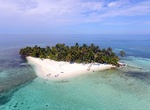
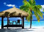
Visit Ranguana Caye, Belize
Ranguana Caye is a two-acre private island located roughly 20 miles west of Placencia. According to Peter Eltringham, author ofThe Rough Guide to Belize, Ranguana Caye has sand softer in comparison to Placencia with taller palm trees. Those exploring the caye, are required to set up transportation through private boat charters. The island includes a dock and moorings ... -
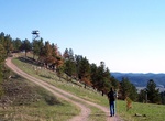
Hike Rankin Ridge Trail, Wind Cave National Park, South Dakota
Rankin Ridge at 5,013 feet is the highest point in Wind Cave National Park. A lookout tower rises above the ridge top, which can be reached via a 250-foot ascent on a 0.55-mile long single track. Take a wide dirt trail back down the ridge to form a one-mile loop. -
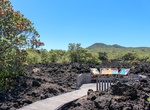
Hike to Rapidan Camp, Shenandoah National Park
Rapidan Camp (also known at times as Camp Hoover) in Shenandoah National Park in Madison County, Virginia, was built by U.S. President Herbert Hoover and his wife Lou Henry Hoover, and served as their rustic retreat throughout Hoover's administration from 1929 to 1933. The first family's residential cabin was known as the "Brown House" in contrast to their more famous... -
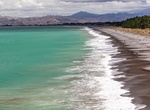
Visit Rarangi Beach, New Zealand
Rarangi is a small coastal community in the South Island of New Zealand which is approximately 15 minutes drive to the north-east of Blenheim, on the coast of Cloudy Bay. -
Visit Rarotonga Island, Cook Islands
Rarotonga is the most populous island of the Cook Islands. Because it is the most populous island, Cook Islanders may often be referred to as Rarotongan, but they may in fact come from one of the other 14 islands in the group, such as Aitutaki or Mangaia. This is similarly the case in the Society Islands where many refer to local inhabitants as "Tahitians" simply beca... -
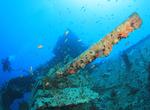
Dive Ras Muhammad National Park, Egypt
Ras Mohammad is a national park in Egypt at the southern extreme of the Sinai Peninsula, overlooking the Gulf of Suez on the west and the Gulf of Aqaba to the east. Ras Mohammad encompasses two islands, Tiran and Sanafir. Tiran Island is located approximately 6 km offshore from the Sinai Peninsula. Underwater caves formed as the result of earthquakes are located in Ra... -
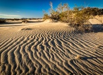
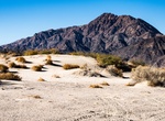
Sandboard Rasor Dunes, California
Rasor Off-Highway Vehicle Recreation Area is an exciting and more remote area for the off-highway vehicle user. The area has rolling hills, open valleys, and sand dunes that invite the rider willing to travel to this area. Elevations range from about 2,427 feet elevation down to about 1,275 feet elevation at the Mojave River. Besides the remote nature of the area, an... -
Off-road Rasor OHV Area, Mojave, California
Rasor Off-Highway Vehicle Area is an exiting and more remote area for the off-highway vehicle user. The area has rolling hills, open valleys, and sand dunes that invite the rider willing to travel to this area. Elevations range from about 2,427 feet elevation down to about 1,275 feet elevation at the Mojave River. Besides the remote nature of the area, another attract... -
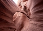
Hike Rattlesnake Canyon (Arizona)
Rattlesnake Canyon is a slot canyon located on private Navajo land in Arizona near Antelope Canyon. As with Antelope Canyon, it has stunning colors abound, and the red sandstone walls feature beautiful, characteristic swirls. The canyon is small and rarely visited slot canyon on private Navajo land along the hike to Antelope Canyon. There is a hole at the top of an a... -
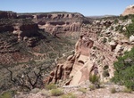
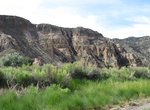
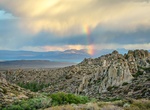
Hike Rattlesnake Canyon (Colorado)
Rattlesnake Canyon is a scenic area within the Black Ridge Canyons Wilderness which in turn forms the core of the Bureau of Land Management administered McInnis Canyons National Conservation Area in west central Colorado. The canyon contains nine natural arches, the second highest concentration of such arches in the United States, after the much better known Arches Na... -
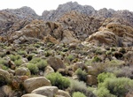
Hike Rattlesnake Canyon (Joshua Tree National Park)
Rattlesnake Canyon is located southeast of Indian Cove Campground in Joshua Tree National Park. There is no marked trail into the canyon. -
Hike Rattlesnake Canyon Loop Trail, Kershaw–Ryan State Park, Nevada
Rattlesnake Canyon Loop Trail is short trail in Kershaw–Ryan State Park. -
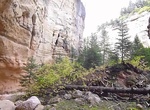
Hike Rattlesnake Creek Trail, Cedar Breaks National Monument, Utah
The Rattlesnake Creek Trail is located just outside Cedar Breaks National Monument park’s north entrance, part of the Ashdown Gorge Wilderness Area. This rugged trail drops 2,500 feet in four miles where it intersects with Ashdown Creek. Hikers can then follow the creek upstream into the canyons of Cedar Breaks, or follow the creek down through the Ashdown Gorge... -
Hike Rattlesnake Gulch, Mono County, California
Canyon north of Mono Lake, near Conway Summit, tributary to Wilson Creek. Elevation: 6870ft, 2094m.
Price: $106.33