Give us feedback!


 See all

Our philosophy is simple. We want to encourage you to dream. BIG! Then we help you plan your trip, get the most out of it while you're traveling and help you share your experience with friends.
Join Now It's FREE
Dream Packages
Duration: 6 days
Price: $606.00
Price: $606.00
Duration: 4 hours
Price: $120.43
Price: $120.43
Duration: 3 hours 30 minutes
Price: $99.36
Price: $99.36
Duration: 8 hours
Price: $83.37
Price: $83.37
Dreams Still To Do
Checked-Off Dreams
Dreams Still To Do
Checked-Off Dreams
Advertisement
Explore Adventure Sports
-
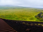
Summit Saxhóll Crater, Snæfellsjökull National Park, Iceland
Saxhóll Crater is a 0.4 mile loop trail up some metal stairs to the top of the crater. The walk up the stairs is fairly easy and has a nice platform at the top. -
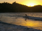
Surf Sayulita, Mexico
Known for its consistent river mouth surf break, roving surfers "discovered" Sayulita in the late 1960s with the construction of Mexican Highway 200. Sayulita is a village about 25 miles north of downtown Puerto Vallarta in the state of Nayarit, Mexico. The best months are when the north swells hit the bay, December through early April. The waves are perfect for all s... -
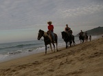
Horseback Riding in Sayulita (Rancho Manuel), Mexico
Horse Back Riding in Sayulita, Mexico with Rancho Manuel. They even let me take the horse into the water and go bareback!! -
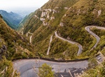
Drive SC-390 in Serra do Rio do Rastro, Brazil
Serra do Rio do Rastro (Mountain Range of the River of the Track) is a mountain range located in the southeast of the state of Santa Catarina, Southern Brazil. It is crossed by the road SC-390, with remarkable landscapes and deep cliffs. This mountain range is situated between the municipalities of Lauro Müller and Bom Jardim da Serra, and its highest point is si... -
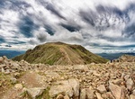
Summit Scafell Pike, Lake District National Park, England
Scafell Pike is a mountain in the Lake District region of Cumbria, England. It has an elevation of 978 metres (3,209 ft) above sea level, making it the highest and the most prominent mountain in England. The mountain is part of the Scafell massif, an extinct volcano, and is one of the Southern Fells. The summit was donated to the National Trust in 1919 by Lord Leconfi... -
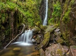
Hike to Scaleber Force, Settle, North Yorkshire
Scaleber Force (also known as Scaleber Foss and Scaleber Waterfall), is a 40-foot (12 m) high waterfall on Stockdale Beck, later the Long Preston Beck, that feeds into the River Ribble between Settle and Long Preston in North Yorkshire, England. The waterfall is the result of geological faulting (part of the South Craven Fault) and is a popular tourist attraction. The... -
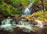
Hike to Scale Force Waterfall, Lake District National Park
Scale Force is considered the highest waterfall in the English Lake District. Opinions vary about how its precise height is calculated, but the total height is normally stated as 170 feet (51.8m). It lies on the stream Scale Beck. The waterfall – or force (a Norse term for waterfall) – is hidden in a deep gorge on the northern flank of Red Pike. It lies so... -
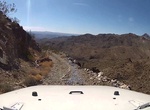
Off-road to Scanlon Bay (Scanlon Ferry Road), Nevada
If you’re looking for one of the most challenging and grueling drives in the country, then Scanlon Ferry Road is for you. The gravel road to Scanlon Bay starts in Gold Butte National Monument and is located on the Nevada side of Lake Mead, across from South Cove. This road is remote, narrow and cliff-exposed, so make sure you and your vehicle are up to the chall... -
Wreck Dive Scapa Flow, Scotland
The scuttling of the German fleet took place at the Royal Navy's base at Scapa Flow, in Scotland, after the end of the First World War. The High Seas Fleet had been interned there under the terms of the Armistice whilst negotiations took place over the fate of the ships. Fearing that all of the ships would be seized and divided amongst the allied powers, the German co... -
Drive Scenic Byway 12, Utah
State Route 12 or Scenic Byway 12 (SR-12), also known as"Highway 12 — A Journey Through Time Scenic Byway", is a state highway designated an All-American Road located in Garfield County and Wayne County, Utah, USA. Proceeding west to east for 122 miles (nearly 200 km), the highway starts south of Panguitch at an intersection with US-89, crosses part of Dixi... -
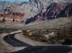
Drive or Bike Scenic Loop Drive, Red Rock Canyon, Nevada
The 13 mile Scenic Drive through Red Rock Canyon allows visitors to explore the highs and lows of the canyon from their vehicle or bicycle, with many scenic stops and and trailheads along the way. Entrance fees support visitor facilities and upkeep for this world-renowned scenic drive. Bicycles are allowed on the one-way Scenic Drive, paved spur roads, and designated... -
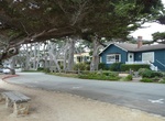
Drive Scenic Road, Carmel-By-The-Sea, California
Scenic Road goes along Carmel Beach in Carmel-By-The-Sea, California. -
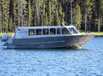
Cruise Scenicruiser, Yellowstone National Park
Come aboard the Lake Queen II for a one-hour guided tour of the largest freshwater lake above 7,000 feet in the United States. The boat departs the Bridge Bay Marina to cruise on Yellowstone Lake with up to seven different times to choose from. Along the way you will learn about the Lake Area Historical District, the remains of the SS E.C. Waters which you will view, ... -
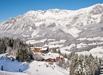
Ski/Snowboard Scheffau am Wilden Kaiser, Austria
Scheffau am Wilden Kaiser is a ski resort town in the district Kufstein in the Austrian region of the Sölllandl. It is located 8.50 km southeast of Kufstein and 13 km northwest of Kitzbühel and has three subdivisions. The main source of income is summer tourism; the village possesses a public swimming area. Located just outside of the village is the Hinters... -
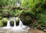
Hike to Schiessentümpel Waterfall, Luxembourg
Schiessentumpel Waterfall is located along the Black Ernz, a river flowing through Luxembourg, joining the Sauer at Grundhof. It flows through the towns of Junglinster and Mullerthal.

Price: $144.00