Give us feedback!


 See all

Our philosophy is simple. We want to encourage you to dream. BIG! Then we help you plan your trip, get the most out of it while you're traveling and help you share your experience with friends.
Join Now It's FREE
Dream Packages
Duration: 2 days
Price: $242.00
Price: $242.00
Duration: 4 hours
Price: $120.43
Price: $120.43
Duration: 7 hours
Price: $179.00
Price: $179.00
Duration: 3 hours 30 minutes
Price: $99.36
Price: $99.36
Dreams Still To Do
Checked-Off Dreams
Dreams Still To Do
Checked-Off Dreams
Advertisement
Explore Adventure Sports
-
Dive Shark Island, Ko Tao, Surat Thani, Thailand
Shark Island offers boulders and rock formations, soft corals. Drift diving for the experienced. See resident turtles, great barracuda, titan triggerfish and clown triggerfish. Max Depth: 28 m Avg Depth: 15 m Avg Visability: 5-30 m Skill: Open water + -
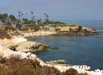
Swim with Sharks in La Jolla Cove, California
With beach access to the water you do not need a boat to swim with sharks in the La Jolla Cove. Check out the sevengill sharks in the summer, in the fall there are schools of leopard sharks and tope sharks. If you can get 10 miles out you might see blue sharks and maco sharks. La Jolla Cove is a small, picturesque cove and beach that is surrounded by cliffs in La Jol... -
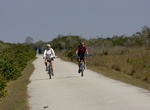
Bike Shark Valley Scenic Loop, Everglades National Park, Florida
The scenic loop is 15 miles (24 km) round-trip. There are no short cuts. If you become unable to complete the entire 15-mile trip, turn around and return on the same road. Bicycling the road takes an average of 2 to 3 hours. The parking lot closes at 6 PM, so be sure to allow yourself enough time. Ride your bike opposite the flow of tram traffic. Start behind the Vis... -
Ride Shark Valley Tram, Everglades National Park, Florida
The two-hour Everglades Tram Tour through the Shark Valley section of Everglades National Park is actually a South Florida ecotour that also provides a wonderful opportunity for group tours. Shark Valley naturalists escort all of our tours, and they are fully prepared to make your journey a memorable one. Besides giving insight into the ecosystem as a whole, your natu... -
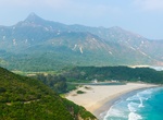
Explore Sharp Peak (Nam She Tsim), Hong Kong
Sharp Peak, also known as Nam She Tsim, is a hill which lies within the Sai Kung East Country Park, north of Tai Long Wan, in the Sai Kung Peninsula in Hong Kong. It is particularly well known for its well defined sharp peak, which rises to a height of 468 metres (1,535 ft) above sea level. The hill is reasonably hard for hikers and should only be attempted in good we... -
Hike to Sharp Point Lookout, Torndirrup National Park, Western Australia
It's a short 0.3 mile loop trail to Sharp Point Lookout. Excellent 270° views over the ocean out to The Gap and Peak Head. -
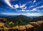
Hike Sharp Top Trail, Lynchburg, Virginia
Sharp Top Trail is locatd at Peaks of Otter, Lynchburg VA. This 2.7 mile trail is difficult but offers great views. -
See Shaunee (Shawnee) Shipwreck, Conception Bay, Namibia
Shawnee ship ran aground in 1976 in Conception Bay on the Namibia coast, about 8 miles north of the Wreck of Eduard Bohlen. -
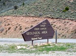
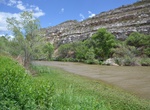
Drive Sheep Creek Geological Loop, Vernal, Utah
This route winds through the dramatic geologic formations of the Sheep Creep National Geologic Area. The Uinta Fault, which runs for more than 100 miles along the north slope of the Uinta Mountains, is clearly visible in the extremely twisted rock layers along the upper part of the loop. But stunning scenery isn't the only reason to keep your camera ready on this bac... -
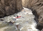
Kayak Sheep Creek Wild and Scenic River, Idaho
Sheep Creek flows through an extremely narrow, winding canyon with sheer vertical walls. High water flows are in the spring and provide for whitewater for the most experienced boaters. Access to Sheep Creek is difficult because of its remoteness and primitive roads. -
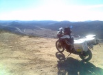
Hike or Off-road Sheephead Mountain Road, San Diego, California
Sheephead Mountain Road Starts near the freeway rest and and winds up the side of Mt. Laguna. It has large water bars and finally ends at a metal barricade. Near the barricade is a large turn around that gives a nice view of the valley below. The trail continued at one time but is now blocked. This trail is located in San Diego County, California. From the Buckman Sp... -
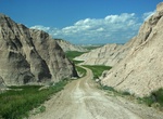
Drive or Mountain Bike Sheep Mountain Road, Badlands National Park, South Dakota
One of the few designated roads is the Sheep Mountain Table Road, 4 miles south of the town of Scenic on Pennington County Road 589. The stunning views from windswept Sheep Mountain Table are accessible under dry conditions, but the road is impassable when wet or snow covered (high clearance vehicles recommended). Please use caution along the unstable cliff edges of t... -
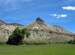
Hike Sheep Rock Overlook Trail, John Day Fossil Beds National Monument, Oregon
Sheep Rock Overlook Trail (0.5 miles round trip) Starting at the front gate to the Cant House, this trail ends at an overlook with a great view of the valley and the river. -
Fish at Sheeps Crossing Fishing Site, Prescott National Forest, Arizona
Sheep's Crossing River Access Point is located near Thousand Trails RV Park between Camp Verde and Cottonwood, AZ. Facilities include parking, a vault toilet, and pedestrian access to the river via a steep, winding path. -
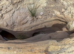
Hike Sheep Tanks Slots, Anza-Borrego Desert State Park, California
The Sheep Tanks are in a slot canyon in the north-eastern part of Anza Borrego Desert State Park - east from the Middle Fork Palm Wash Slots. The slot canyon has several deep water pockets (called tinajas). It is an important watering hole for Bighorn Sheep (hence the name Sheep Tanks) and other wildlife.


Price: $176.03