Give us feedback!


 See all

Our philosophy is simple. We want to encourage you to dream. BIG! Then we help you plan your trip, get the most out of it while you're traveling and help you share your experience with friends.
Join Now It's FREE
Dream Packages
Duration: 8 hours
Price: $83.37
Price: $83.37
Duration: 8 hours
Price: $220.83
Price: $220.83
Duration: 15 hours
Price: $149.00
Price: $149.00
Duration: 4 hours 30 minutes
Price: $176.03
Price: $176.03
Dreams Still To Do
Checked-Off Dreams
Dreams Still To Do
Checked-Off Dreams
Advertisement
Explore Adventure Sports
-
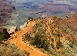
Hike South Kaibab Trail to Phantom Ranch, Grand Canyon National Park, Arizona
The South Kaibab Trail is a 7.1 mi (11.4 km) hiking trail in Grand Canyon National Park, located in the U.S. state of Arizona. Unlike the Bright Angel Trail which also begins at the south rim of Grand Canyon and leads to the Colorado River, the South Kaibab Trail follows a ridge out to Skeleton Point allowing for 360-degree views of the canyon. The South Kaibab T... -
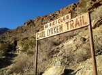
Hike South Lykken Trail, Palm Springs, California
South Lykken Trail is a 4.5 mile trail (1,000 foot elevation gain) on the sourthern end of Palm Springs, California. The 4 hour hike offers scenic views of the mountains and city. The trail is easy iat first then has a pretty good incline for about half a mile. It then winds up the mountain the rest of the trail. The picnic area can also be reach from the Agua Calient... -
Dive South Malé Atoll, Maldives
The Male Atoll is divided into 2 sections, the North Male Atoll and the South Male Atoll. They are both located on the eastern side of the Maldives. The South Male Atoll is home to a number of tourist resorts and some of the finest scuba diving in the Maldives. Cocoa Corner (Cocoa Thila) is a dive site that can be explored in several different ways and with the right ... -
Hike South & North Fortuna Loop, Mission Trails Park, San Diego, California
South Fortuna & North Fortuna Mountains are located Mission Trails Regional Park. There are two main paths to the peak: Starting from West Fortuna Staging Area (Clairemont Mesa Blvd) it's a about 8 miles. Starting from San Diego River Crossing Staging Area (Mission Gorge Rd) it's a 7.8 miles. The trail is a moderate hike used for hiking, nature trips, trail r... -
Visit South of the Border, South Carolina
South of the Border is a rest stop and roadside attraction on Interstate 95 and US Highway 301/501 between Dillon, South Carolina and Rowland, North Carolina. It is so named because it is just south of the border between the U.S. states of North Carolina and South Carolina. The rest area features not only restaurants, gas stations and a motel, but also a small amuseme... -
Visit South Padre Island, Texas
South Padre Island is a resort town in Cameron County, Texas, United States. The town is located on South Padre Island, a barrier island along the Texas Gulf Coast accessible via a causeway from the town of Port Isabel. South Padre is home to many watersport activities with personal water craft rental, kiteboarding and dolphin watches being the most popular. Other fav... -
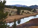
Explore South Platte River, Colorado
The South Platte River is one of the two principal tributaries of the Platte River and is itself a major river of the American Midwest and the American Southwest/Mountain West, located in the U.S. states of Colorado and Nebraska. Its drainage basin includes much of the eastern flank of the Rocky Mountains in Colorado; much of the populated region known as the Colorado... -
Drive South Rim Drive, Gunnison National Park, Colorado
Scenic Drives within the National Park provide a particularly enjoyable experience. The South Rim Drive is 7 miles from Tomichi Point to High Point sporting 12 distinct overlooks. Most are reached by walking a short trail from a turnout. Allow 2-3 hours to allow for viewing from several of the overlooks. Those with limited time should consider stopping at Gunnison Poi... -
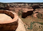
Drive South Rim Drive Hwy, Canyon de Chelly National Monument, Arizona
Check out the views of Canyon de Chelly from the rim, following the South Rim Drive Hwy. Ancient ruins and geologic structures are visible, but in the distance, from turnoffs. -
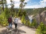
Hike South Rim Trail, Yellowstone National Park, Wyoming
Begin this trail at the Wapiti Lake Trailhead on South Rim Drive near Chittenden Bridge. This partially paved trail parallels the canyon and connects the Wapiti Lake Trailhead with Uncle Tom’s Point and Artist Point (1.75 miles/2.8 km). You’ll wind in and out of forests between striking viewpoints of both falls and the canyon. Beyond Artist Point, the trai... -
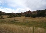
Hike South Rim Trail, Roxborough State Park, Colorado
The South Rim Trail in Roxborough State Park (Colorado) begins approximately 0.5 miles from the Visitor Center starting on the Carpenter Peak Trail. The South Rim Trail is a single track trail that is considered moderate for hiking difficulty. It is approximately 1.8 miles long with approximately a 500 foot elevation gain. The trail connects to the Carpenter Peak and ... -
Hike South Rim Trail (Big Bend National Park), Texas
This challenging trail is well worth the 2,000 foot gain, as midway are the stunning vistas from the South Rim. Ascend either the steeper Pinnacles or more gradual Laguna Meadows Trail. During Peregrine Falcon nesting season, the Northeast and Southeast portions of this trail are closed. -
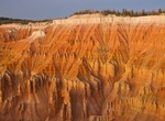
Hike South Rim Trail (Spectra Point/Ramparts Overlook), Cedar Breaks National Monument, Utah
The Spectra Point/Ramparts Overlook Trail is a four-mile round-trip along the rim, with spectacular views in all directions. The bristlecone pines, one of the longest-living species of trees, are found along this trail. The oldest known tree in the monument is over 1,600 years old. At 10,500 feet, this hike is moderately strenuous and is not recommended for persons w... -
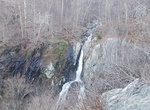
Hike to South River Falls, Shenandoah National Park, Virginia
Located at mile 62.8 in the Central District of the park, is truly spectacular. It’s a waterfall of 83 feet, the third tallest in the park. A rock ledge with a stone guard wall offers you a good resting place as you enjoy the sight—and the thundering sound—of falling water. The hike is 2.6 miles roundtrip, with a climb of 850 feet. -
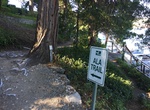
Hike South Shore Trail (ALA Trail Lake Arrowhead), California
The 6 mile round trip South Shore Trail on Lake Arrowhead follows the lake from Lake Arrow Village to past the dam. You will need the access code to the Arrowhead Lake Association gates since the trail is on private property. You should be able to get access codes from your hotel.


Price: $469.00